
Observation Date
1/3/2023
Observer Name
Champion/Antenucci
Region
Salt Lake » Park City Ridgeline » Pinecone Ridge
Location Name or Route
Scotts Pass - Park City Ridgeline
Comments
Areas odeepestighest concern continue to be those where the snowpack overall is a bit shallower. Before the most recent storm, we continued to see a bit more consistent avalanche activity and results in snowpits. This includes zones like the Park City Ridgeline, Millcreek, and lower in the Cottonwoods.
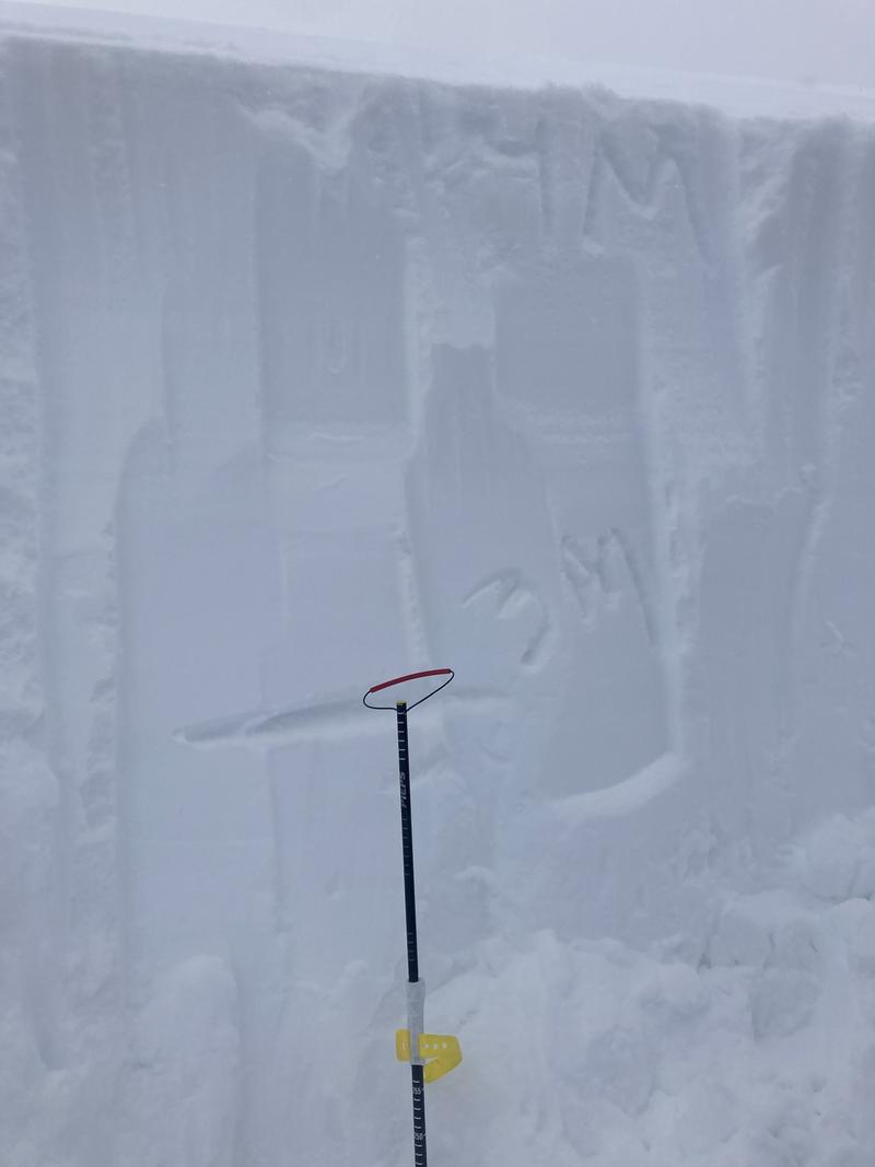
Today, we headed up to the Park City ridgeline to look at slopes representative to those who have had recent close calls and avalanche activity failing down on the PWL. While traveling up Scott's Pass towards the Park City ridgeline, visibility was limited, with light snowfall throughout the tour, a low cloud deck, and a fog layer moving in and out of the mountains. Widespread rime seemed to have covered every surface making the skinning, and trees very photogenic. Once we got near Scott's Pass we could see evidence of recent activity within PCMR that failed on the PWL with explosives. We made our way towards Pinecone ridge looking for representative slopes between Scotts Hill and Pinecone Ridge to find that PWL. Initially, we dropped off the Ridgeline, onto a North facing aspect into terrain that didn't appear too strongly wind-loaded but found over 4 meters of snow. We then continued along the ridgeline to find somewhere a bit shallower, and ended up on a North Aspect right at 9,990'. We found a snowpit depth of 195cm with multiple density changes and graupel layers in the recent storm snow. At the ground, we could still find the more prominent (1-2mm) faceted grains ranging from 4F to 1F in hardness. While we could still find these grains, we were unable to get any results within our pit on that layer. We even tried removing half of the slab, making the total height 120cm, and still were unable to get results within or on the faceted layer.
So what does this mean? I think we are trending in the right direction, we have added a lot of snow and insulation to these grains and they seem to be gaining strength. That does not mean that we are out of the woods, we are still seeing avalanches on this layer, and the likelihood is just continuing to decrease. We are in an area of lower likelihood, but a higher consequence. If you do find an area, where the slab is a bit shallower and is able to trigger an avalanche on these weak faceted grains, these will be large and dangerous avalanches. I'd continue to dig down, look for the grains, and keep tracking them.
4 Meter Snowpack
Video
Today's Observed Danger Rating
Considerable
Tomorrows Estimated Danger Rating
Considerable
Coordinates


