Observation Date
1/2/2023
Observer Name
Garcia, Nauman, Ament, Kennard
Region
Moab » Laurel Highway » North Woods
Location Name or Route
Laurel Highway, North Woods
Weather
Sky
Obscured
Precipitation
Light Snowfall
Wind Direction
South
Wind Speed
Moderate
Weather Comments
Light to Moderate winds out of the South on ridgelines above 11k.
Snow Characteristics
New Snow Depth
10"
New Snow Density
Medium
Snow Surface Conditions
Powder
Snow Characteristics Comments
This storm has done wonders for our snowpack. Conditions today were about as good as they get. The dense, heavy snow over the past six days has really filled things in. The heavy wet snow has done a great job of covering up stumps, logs, and other obstacles in the trees. Today we were treated to ten inches of medium density pow on top of a super supportable base. The most recent 10 inches did not have slab like properties.
Red Flags
Red Flags
Wind Loading
Poor Snowpack Structure
Red Flags Comments
Winds have been steadily decreasing since 6 AM Monday. We observed light snow transport ATL loading leeward slopes.
Poor snowpack structure remains. In our pit today the facets were buried down 140 cm.
Avalanche Problem #1
Problem
Persistent Weak Layer
Problem #1 Comments
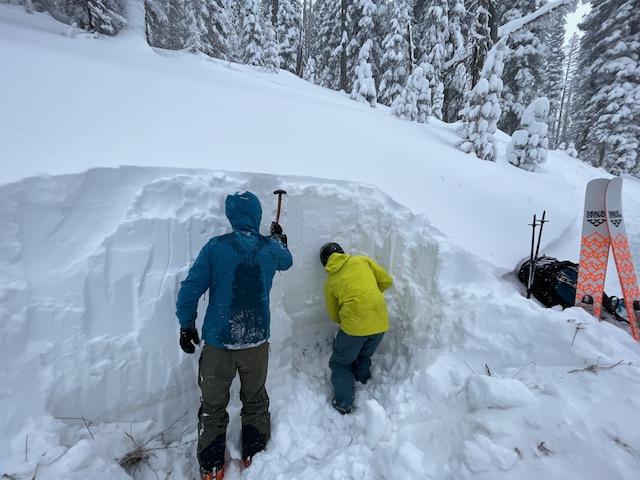
In the short term we are still looking at high and considerable danger. But for the long term, we may be turning a corner, especially on slopes with a deeper snowpack. Today on a North facing slope at 10,630 ft, we found the buried facets below 140 cm of snow with a stiff 1F slab above. HS 180 cm. A Deep Tap test produced a DT28 BRK. (That is a non planar, irregular fracture on 28 taps). The faceted layer has gained some hardness. The upper part of the facets are 4F-, while the bottom half of the weak layer is now 4F. Faceted grains are still 2mm in size. It would appear the weak layer has gained some strength on slopes with a deep pack. I still have concern for areas with a more shallow snowpack like windward slopes and the southerlies. On these slopes the buried facets are not as deep and will not be gaining strength the same way we saw in our pit today. As the storm quiets down and we get some vis, it will be interesting to see what if any avalanche activity occurred during the most recent loading event.
Avalanche Problem #2
Problem
Wind Drifted Snow
Trend
Decreasing Danger
Problem #2 Comments
We observed light snow transport today. On Sunday I observed strong Southerly winds and a lot of blowing and drifting snow above treeline. These drifts will be stiff and stubborn, but it will still be possible to trigger an avalanche on recently wind loaded slopes.
In this very deep pit wall you can make out the dust layer at just about our knee level. The buried weak layer is in this dust layer, 140 cm down.
It was snowing hard at the end of our day. If snowfall continues and we wake up to big accumulations or if the winds pick up the danger will remain high. If the snow is done and the wind stays calm like it is now we could drop back to Considerable tomorrow.
Today's Observed Danger Rating
High
Tomorrows Estimated Danger Rating
None
Coordinates