Observation Date
12/14/2022
Observer Name
Zimmerman-Wall/ AIARE PRO 1
Region
Salt Lake » Little Cottonwood Canyon » Snowbird periphery » Upper AF
Location Name or Route
Sinner's Pass
Weather
Sky
Broken
Precipitation
Light Snowfall
Wind Direction
Northwest
Wind Speed
Light
Weather Comments
Clouds lingered and produced light snowfall for most of the day. Intermittent sun broke through and illuminated the landscapes for the first time in days. This was not enough solar input to dramatically impact the low density snow, but may have contributed to one long running dry loose. The wind was moving snow around, but not doing much more than drifting and etching the surfaces on upper elevation leeward slopes (Easterly). All the trees are still caked in snow at all elevations.
Snow Characteristics
New Snow Depth
2'
New Snow Density
Low
Snow Surface Conditions
Powder
Snow Characteristics Comments
Five star riding quality and easy to move through on lower slope angles. Very low density snow over the last day stacking up on top of low density snow from days prior. Totals in upper AF seemed similar to upper LCC.
Red Flags
Red Flags
Recent Avalanches
Red Flags Comments
There were minimal signs of instability in the terrain visited today, aside from a long running dry loose and some localized collapsing/whumping around rocky knolls where the structure was shallow and weak.
Avalanche Problem #1
Problem
New Snow
Trend
Same
Problem #1 Comments
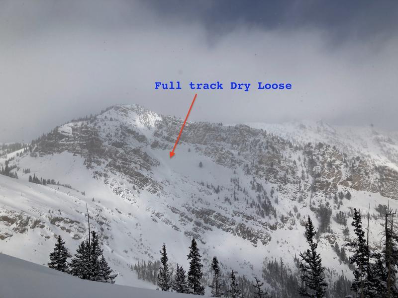
Dry loose avalanche were noted in the steepest sustained terrain. Our group noted a narrow but very long running sluff on the south facing sugar cliffs in lower mineral basin. See photo. Otherwise the new snow doesn't have slab like properties and is not very cohesive.
Avalanche Problem #2
Problem
Persistent Weak Layer
Trend
Same
Problem #2 Comments
It seems like this problem is more pronounced in the shallower lower elevation band adjacent to the core of upper Little Cottonwood and upper American Fork where HS is reaching 180+cm. In many locations the wind event of 12/11 has put a 1F to Pencil hard windslab overtop the 4F-1F faceted grains that were buried 11/28. This very strong layer seems to have capped the weak layer in a lot of areas and it is topped with almost 2.5 feet of low density snow that is not very cohesive at this point. In areas where this layer is nearer to the surface, such as off-aspects or slopes that were made shallower by the wind prior to the storms of late November it still seems like this problem is a concern. While the distribution is widespread it is stubborn to unreactive in test profiles and many ECTN or ECTX across the mid elevation band where it is buried 80-90cm deep. In the area traveled there was also extensive snowmobile usage and no signs of instability or prior avalanches. That being said the terrain we were in was quite avalanche resistant and the larger slopes of Pagan Basin had been well avoided by all users.
We seem to be heading in the right direction with the increasing snowpack depths and characteristics of this layer being smaller grains (1-2mm).
Would still like to let things settle and see how the next bit of moisture and wind changes the overlying slab characteristics. Not trying to outsmart this one. Its only mid December and there will be plenty of quality riding to be had in the future on the steeper slopes.
Comments
Photos:
1- Loose Dry on steep sustained South facing slope. Brief solar input likely warmed the rocks of the starting zones and the sluff entrained more snow as it ran to the bottom of the track of this slope, traveling through multiple cliff bands.
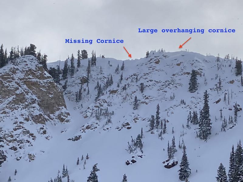
2- Cornices along the top of Pagan basin were growing larger and it looked like the cornice line on the left had numerous chunks that had broken off during the storm. No evidence on the slope below.
Today's Observed Danger Rating
Considerable
Tomorrows Estimated Danger Rating
None
Coordinates