
Observation Date
1/14/2022
Observer Name
Coyne
Region
Salt Lake » Big Cottonwood Canyon » Days Fork » Chicken Sh#! Ridge
Location Name or Route
Chicken Sh!t Ridge
Comments
What a great season thus far. I am overall amazed at the coverage and I think we are all relieved to see some yellows and greens on the danger rose!
Today, I ventured out for a high pressure recon day. I was curious to head out to some mid elevation northerly facing terrain in mid BCC. In particular I wanted to look at the height of snow and the snowpack in terrain I might want storm ski in when and if another one swings our way.
We don't have a lot of info from Days Fork area during previous avalanche cycles, but I remembered Staples ventured out there mid-December and had a lot of collapsing and some remotely triggered avalanches. I wanted to see what some of these slopes looked like now. We know there is some rounding in the old Oct/Nov snow on northerly facing terrain, but what about in areas that avalanched?
Was there still a PWL that would set up for a repeater? Was the snowpack so thin it was rotting out rapidly with this period of high pressure?
At 9,000ft HS from the SE to E to NE trended between 85cm and 135cm with more snow settlement on the southerly facing slopes. Given the relatively shallow snowpack, we know skiers and riders can trigger weak layers buried about a meter deep. One question answered: Yes, my body weight could trigger an avalanche here.
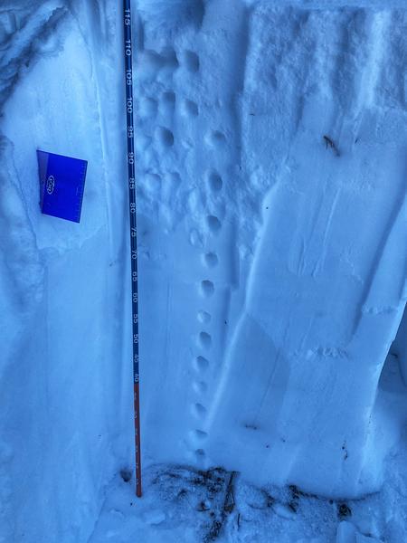
I dug out on a small steep NE facing aspect at 9000ft, figuring it looked like an area that could have avalanched back in mid-Dec. Thankfully I was right and didn't have to dig a second hole.
My HS was 120cm with NSF in the top 5cm or so, progressing 4F to 1F in the December storm slab. I check my compass about 6 times to ensure I wasn't getting tricked as it feels out of place to dig NE at 9000ft and not see a pile of scary facets in Days Fork, confirming, this NE facing slope has slid and there were just a few remnants of now rounding facets at the ground interface. Results were as one would expect with a nice structure like this with a CTN and ECTX. Prying the block out even peeled up some moist dirt.
What does this mean? Well, not a whole lot except that this single slope slid and by the looks of my 150cm wide hole it appears to have the good structure right now as the PWL was wiped clean back in the touchy part of December. JUST ON THIS SLOPE.
Will I go back here for a storm skiing day? Depends. You gotta walk underneath a handful of huge avalanche paths that didn't appear to have climax avalanches yet. Will they? Hard telling, not knowing. What we do know is that we HAVE seen many size 4 avalanches throughout the range, I think I'll pay these big slopes respect if we get a good wallop down the road. Then you have the NSF. Skis good now, super fun, surfy, and playful, but the pessimist in me says 100cm deep in a snowpack is a bad spot for a new PWL as avalanches could be well connected around terrain features.
What did I learn today?
1) Some areas that slid, might have wiped out the PWL, my guess is this isn't the case everywhere...
2) We are seeing a good about of Near Surface Faceting on the shady part of the compass that will likely play a role in future avalanche cycles.
3) Not everything slid huge.
4) I still really like walking and skiing.
Photos:
1) Good structure
2) Old PWL
3) New PWL?
Today's Observed Danger Rating
Moderate
Tomorrows Estimated Danger Rating
Moderate
Coordinates


