Observation: Scotts Peak

Observation Date
1/6/2022
Observer Name
Bruce Tremper
Region
Salt Lake » Big Cottonwood Canyon » Scotts Peak
Location Name or Route
Scott's Peak
Weather
Sky
Broken
Wind Direction
West
Wind Speed
Light
Weather Comments
After two days of very ferocious west wind and very dense snow, it was finally relative calm with patches of sun coming through. Much warmer temperatures.
Snow Characteristics
New Snow Depth
11"
Snow Surface Conditions
Dense Loose
Rain-Rime Crust
Damp
Snow Characteristics Comments
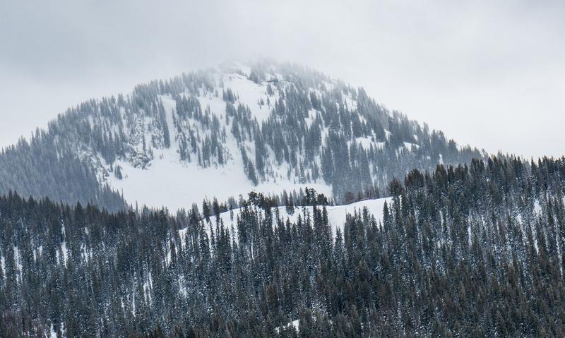
The new snow these past two days is extremely dense, perhaps 30 percent water, and it really has some heft to it. It's so dense that on skis you stay very close to the surface and it can be kind of fun, surfy snow. But it's only nice at high elevations above about 9,500 feet, below which, it's quite damp. The wind obviously had its way with the snow with extensive areas of wind damage at upper elevation wind exposed terrain. Even in lower elevation trees, the wind was so strong and variable that it has wind drifted tails behind most every tree. The upper elevations ridges, such as the Park City ridge line, is completely denuded of snow, which was redistributed onto the downwind, north through east facing terrain, probably in deep, hefty drifts.
Red Flags
Red Flags
Recent Avalanches
Heavy Snowfall
Wind Loading
Rapid Warming
Poor Snowpack Structure
Red Flags Comments
Five out of six red flags checked add up to no good. Extremely dense snow yesterday combined with extremely strong wind these past couple days have created widespread areas of wind affected snow. The upper elevation, windward slopes are bare rocks with all that snow redistributed onto the downwind east facing slopes into deep, really hefty drifts. I'm sure there were lots of wind slab avalanches visible today but I was hunkered down in non-representative terrain. I could see one fresh wind slab avalanche (submitted separately) on the northwest spur of Peak 10,420 on a notoriously avalanche-prone slope called Lane's Leap. It's northeast facing, about 40 degrees in steepness. I viewed the avalanche from adjacent terrain but it looked to be 2 feet deep and perhaps 200 feet wide at 9,600'. I'm guessing the wind slabs will settle out quickly because they are so warm and damp. I'm cabin sitting in Forest Glen off the Guardsman's Pass road this week and it's easy to notice all the cabins with metal roofs produced big slab avalanches today because of the warming temperatures after being loaded with copious amounts of wind drifted snow these past couple days. I've attached a couple photos, one of the 10,420 avalanche in flat light (on the foreground ridge with Clayton Peak in the background), the other was a typical roof avalanche seen on many cabins today. Watch for more activity with the forecasted warmer temperatures. Needless to say all this new snow weighs a LOT and it has to be overloading the well-advertised depth hoar near the ground on many of the steep, shaded slopes. If it ain't one thing, it's the other. Today I stayed in very conservative terrain
Avalanche Problem #1
Problem
Wind Drifted Snow
Trend
Decreasing Danger
Problem #1 Comments
See discussion above
Avalanche Problem #2
Problem
Persistent Weak Layer
Trend
Same
Problem #2 Comments
See above discussion
Today's Observed Danger Rating
High
Tomorrows Estimated Danger Rating
None