Observation: Catherine's Pass

Observation Date
10/26/2021
Observer Name
Gagne/Donner
Region
Salt Lake » Little Cottonwood Canyon » Catherine's Pass
Location Name or Route
Catherine's Pass - Point Supreme
Weather
Sky
Obscured
Precipitation
Moderate Snowfall
Wind Direction
Northwest
Wind Speed
Moderate
Weather Comments
Occasional brief periods of intense snowfall. Winds were most noticeable weather event with sustained moderate to strong northwest winds along ridgetops.
Snow Characteristics
New Snow Depth
10"
New Snow Density
Medium
Snow Surface Conditions
Powder
Wind Crust
Snow Characteristics Comments
HS 60-75 cms with top ~30 cms storm snow.
There is a density inversion mid-way through storm snow that meant for easily-propagating cracking. (Other observers from Tuesday noted this as well.)
We found fresh wind drifts along upper elevation ridges from the northwest winds but they were unreactive to ski cuts and other quick stability tests.
Old snow prior to this weekend was damp/wet down to the ground with no weak snow found.
Red Flags
Red Flags
Heavy Snowfall
Wind Loading
Cracking
Red Flags Comments
Despite finding three red flags, they were all wind and storm snow-related with no persistent weaknesses in the underlying snowpack noted.
Avalanche Problem #1
Problem
Wind Drifted Snow
Trend
Decreasing Danger
Problem #1 Comments
Wind drifts from the northwest winds will be found along upper (and some mid) elevation slopes on leeward aspects (northeast through south). Although they were not reactive on Tuesday, it would not surprise me to find a few reactive drifts at the upper elevations on Wednesday morning.
Avalanche Problem #2
Problem
New Snow
Trend
Decreasing Danger
Problem #2 Comments
Any cracking or other instabilities within the storm snow should quickly settled out by Wednesday.
Comments
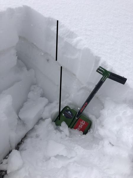
Fresh wind drifts and cracking in the storm snow did not surprise me. But I was mostly interested in how the snowpack prior to this weekend now looked. We found the old snowpack to be damp/wet down to the ground on all aspects up to 10,500' with no persistent weaknesses. The storm snow has bonded well to the old snowpack, and recent storm and wind instabilities will quickly settle out.
Overall a solid snowpack for late October. Going forward, with high pressure beginning later this week, the recent storm snow will likely weaken at the surface on shady mid and upper elevation aspects, but for now it seems we do not have any weaknesses down near the ground.
Today's Observed Danger Rating
None
Tomorrows Estimated Danger Rating
None
Coordinates