Observation Date
3/1/2021
Observer Name
T Diegel
Region
Salt Lake
Location Name or Route
White Pine/Red Baldy
Comments
I took the time to dig a pit on the lower slopes of Red Baldy (NW facing) to make see how the 'pack was, since I felt pretty small and exposed there. Even though I think that line had slid earlier in the season, the total snowpack was 260 cms and even though I with a probe I could feel the "gap" for the last 50cms to the ground, there was still 2m above that that was super solid. It seems to me that with 2m of ever-increasing strength (top to bottom) of the snow above the PWL doesn't have much likelihood to be triggered by a couple hundred pounds of skier/gear shuffling over it (to be sure, I had seen some early-morn bombing from Snowbird patrollers atop Red Top that didn't seem to produce anything; that always helps the confidence).
Is the well-advertised PWL now buried deep enough? I think the answer is yes.....in some places, but not all. (Mill Creek Canyon seems to have about 2/3 the snowpack that upper LCC has; so there's less of a phat snowpack above the PWL).
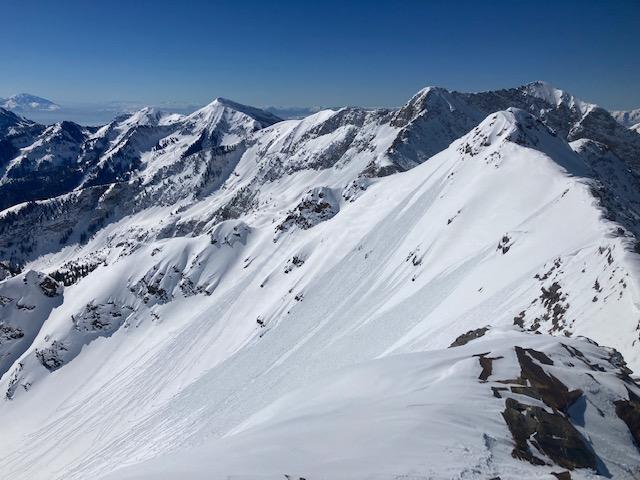
That said, it was clear that there was a fair bit of wind lately (see pic of Red Stack/Mary Ellen with the tops of the ridges blown clean of snow) so the many steep E/NE slopes that have gotten loaded may still be suspect? Or cross-loading? And there were already some small point releases on steep SE facing lines by noon. (another pic).
And indeed, watch out for cornices. I am usually chastised for getting too close to them, and even a bobcat (I think) knows to give them a decent berth (the other pic).
As I got higher and wrapped around to West and then SW-facing it seemed that the new snow didn't bond as well to the sun crust; something that we noted yesterday in south-facing terrain yesterday.


My ratings for today reflect the propensity for 8-10" wet slabs running on the crust, which is not what I saw/experienced. And I think the same could happen tomorrow. It was quite warm in the sun today.
Today's Observed Danger Rating
Considerable
Tomorrows Estimated Danger Rating
Considerable
Coordinates


