Observation: Knob Mountain

Observation Date
1/23/2021
Observer Name
John Pikus & Zeb Engberg
Region
Skyline » Cedar Creek » Knob Mountain
Location Name or Route
Knob Mountain & Cow Fork
Weather
Sky
Obscured
Precipitation
Light Snowfall
Wind Direction
Southwest
Wind Speed
Moderate
Weather Comments
Snow showers decreased in intensity throughout the day, tapering off entirely by around 1pm. Winds were moderate in the morning and early afternoon and were moving snow around on exposed ridgelines. Skies began clearing in the late afternoon and wind speeds decreased making for a pleasant evening.
Snow Characteristics
New Snow Depth
8"
New Snow Density
High
Snow Surface Conditions
Powder
Wind Crust
Snow Characteristics Comments
About 3 inches of new snow at the base of the canyons, increasing to 8 inches at 9,500 feet. Around 8,800 feet the amount of new snow seemed to increase pretty dramatically. New snow was uniform density, on the moderate to high side but skied very well. The winds were transporting significant amounts of snow on and below ridgelines with many new soft wind drifts present.
Red Flags
Red Flags
Heavy Snowfall
Wind Loading
Cracking
Collapsing
Poor Snowpack Structure
Avalanche Problem #1
Problem
Wind Drifted Snow
Trend
Decreasing Danger
Problem #1 Comments
Both new and old wind drifts were present and scattered in fairly unusual areas due to a wide variety of wind directions and intensities over the past week. We experienced a scary collapse that got our attention on a NW slope around 9,600 feet in elevation. This surprised us as we had not experienced any outward signs of instability to this point. The culprit was a hard wind slab, covered by the new snow on top of a very weak layer of faceted snow. This structure concerned us and is likely present in high elevation start zones and could result in violent avalanches.
Avalanche Problem #2
Problem
Persistent Weak Layer
Trend
Same
Problem #2 Comments
Under the new snow our snowpack consists of mostly faceted snow of various weakness depending on the area. We found a particularly concerning layer of weak snow right under a heat crust formed during the recent warm temperatures.
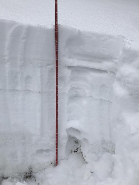
Travel today was on Knob Mountain and the Cow Fork at elevations ranging from 7,000 to 10,150 feet on slopes of all aspects. The new high density snow greatly improved ski conditions and filled things in pretty nicely. We were curious as to how the old snow had changed in the two weeks since we were last in this area so we dug a pit on a NW facing slope at around 9,500 feet (see photo.) The snow depth here is 95 cm which for this season on the Skyline seems to be on the deeper side. In this location the faceted snow at the bottom foot of the snowpack seems to be gaining strength. It was more cohesive than the last time we were here. However the snow above this has weakened substantially over this two week stretch. The old snow is capped by a thin thermal crust at 75 cm with the weakest snow right below this crust (note that we did not find this crust layer everywhere.) We got a test result of ECTP8 failing on this layer.
At this point the snowpack seems to have a high degree of spatial variability. The snowpack is pretty weak everywhere but exactly how weak it is depends on the snow depth and exposure to wind. In some places there is a semblence of a slab over the November snow whereas in most places the whole snowpack is junk. Biggest danger today was windslabs over the weak faceted snow. Some of these slabs are quite thick and hard and it would not be fun to tangle with them.
Today's Observed Danger Rating
Considerable
Tomorrows Estimated Danger Rating
Considerable
Coordinates