Observation Date
1/25/2020
Observer Name
Nauman, Howell, Wilson
Region
Moab
Location Name or Route
Dark Side to Talking Mtn
Weather
Sky
Few
Wind Speed
Calm
Weather Comments
It was a day in the sun above the inverted valley with almost no wind. The sun was quite bright and warmed up the snow on southerly exposures which will likely crust over tonight. There were a few orographic clouds around noon that cleared out with a light to moderate breeze that picked up from the NW around 3pm, but seemed to die out by 4pm. Pretty nice day to be up high.
Snow Characteristics
Snow Surface Conditions
Powder
Dense Loose
Wind Crust
Melt-Freeze Crust
Snow Characteristics Comments
The snow is pretty variable by aspect, south faces will probably be crusted over tomorrow. Other aspects are pretty soft if they have been sheltered from the wind since the last storm (1/21). Still pretty good!
Red Flags
Red Flags
Recent Avalanches
Wind Loading
Rapid Warming
Poor Snowpack Structure
Red Flags Comments
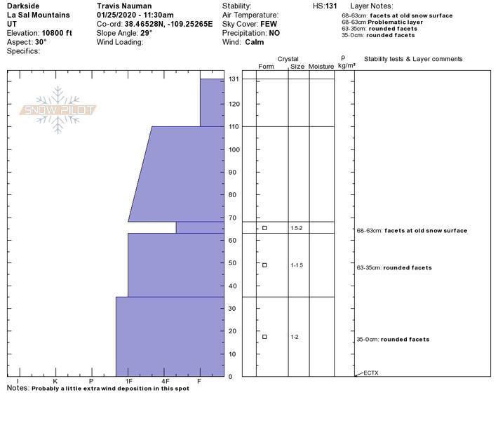
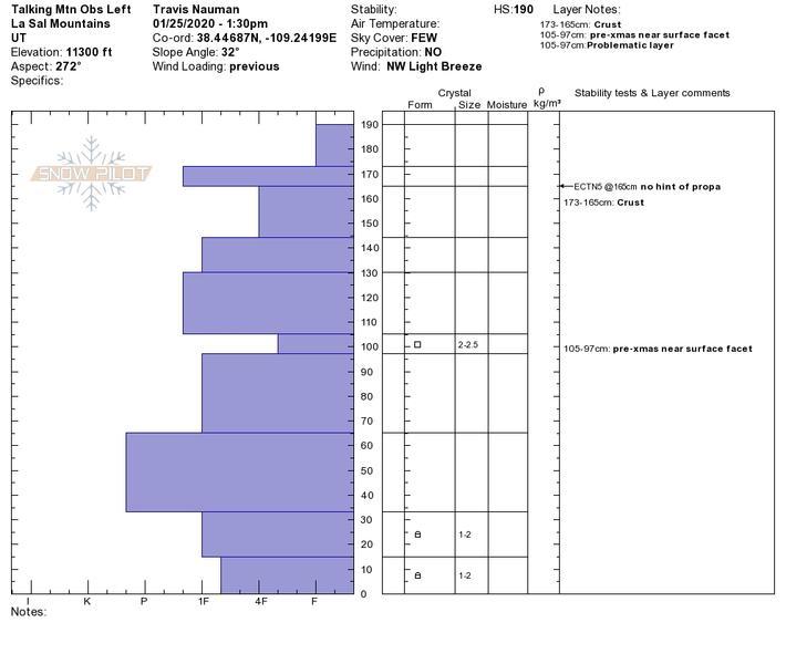
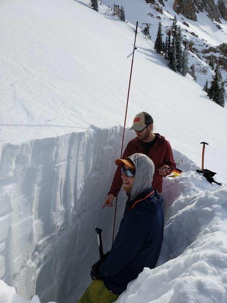
We noticed an avalanche to the lookers left of Lone Pine that probably went sometime 1.21 o 1.22 that broke right below wind loaded cliff bands (pic below). Much of the alpine has been worked hard by the wind, but there are more sheltered areas than expected where the snow if pretty nice. Both of the pits (NE and W between 10,800 and 11,300 ft) we dug today had faceted layers 5-10 cm thick mid profile that I think are from our pre-xmas high pressure period. We tested these layers thoroughly and could not get them to react in ECTs. The southern aspects got wet today with many roller balls and even on small point release wet slide in talking mtn - the sun was hot! Other than the facets, the snow we evaluated was pretty strong and mostly right side up. Above 11,400 the last storm snow started to feel less bonded to the old snow surface and we decided not to ascend any higher.
Avalanche Problem #1
Problem
Wind Drifted Snow
Trend
Decreasing Danger
Problem #1 Comments
There are still many very complicated wind slabs that we avoided today, there were particularly crazy looking on all of the north faces in gold basin. Although the wind was mostly calm today, a small period of wind in the afternoon started immediately transporting snow despite not being very strong. There is still a lot of loose snow available for transport, hopefully the wind will stay away for a while so we can enjoy this snow.
Avalanche Problem #2
Problem
Persistent Weak Layer
Trend
Same
Problem #2 Comments
Mid snow pack facets existed in both profiles (NE and W) that we examined. They were unreactive today, but they are there and could reactivate with the wrong sequence of changing conditions.
Comments
Snow profile from the Dark Side (10,800 ft, NE aspect). No ECT result despite facets 63 cm below snow surface.
Snow pit in talking mountain (11,300, W aspect). There was 190 cm of snow here! I think this area has been getting wind deposition, but was not wind slabby at all... Or maybe they have just gotten way more snow up there. Again this profile had one particular weak layer 85 cm below the surface, but was non reactive. We had an ECTN 5 25cm below the surface on the old snow that was really more of the snow just being soft. There was not any hint of propagation.
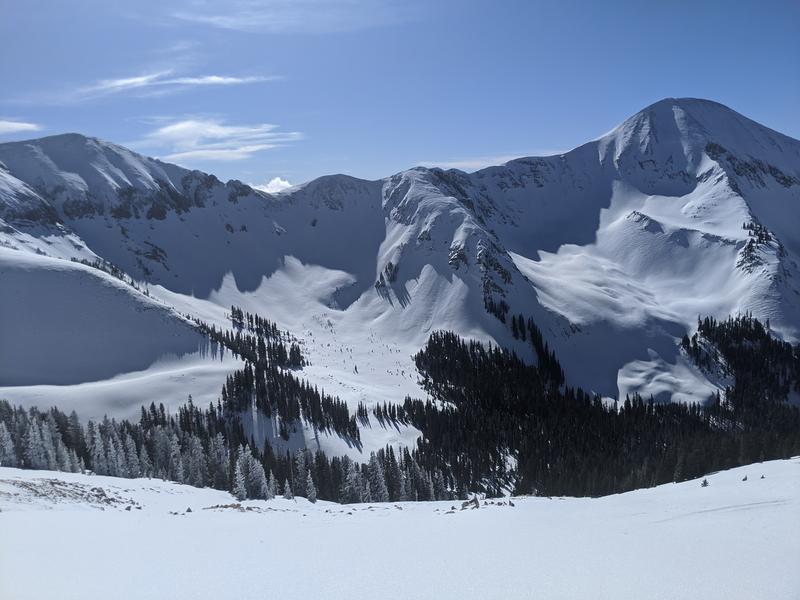
Avalanche debris to the lookers left of Lone Pine that started from wind slabs in the cliffs - seem similar to the slides Eric documented 1.22 Forecaster note: These are the same avalanches.
Today's Observed Danger Rating
Moderate
Tomorrows Estimated Danger Rating
Moderate
Coordinates