Observation: Cutler Ridge

Observation Date
1/25/2020
Observer Name
Derek DeBruin
Region
Ogden » Ben Lomond » Cutler Ridge
Location Name or Route
Ben Lomond, Cutler Ridge
Weather
Weather Comments
Warm day, seemingly above freezing temps throughout from the trailhead up to 7800ft. Began the day quite socked in, but the fog began lifting by noon, leaving partly to mostly cloudy skies in its stead, with clouds hanging out only on the summits and ridgelines. Winds were generally calm, picking up a bit at the mid elevations during the afternoon, with limited snow transport present.
Snow Characteristics
Snow Surface Conditions
Dense Loose
Melt-Freeze Crust
Damp
Snow Characteristics Comments
Found a melt freeze crust below the new snow at low elevations, particularly southerlies, but this seemed to have softened by end of day. Otherwise, plenty of damp mashed potatoes in the low elevations. Snow was surprisingly decent above 7000ft, with consistent turns. Snow was drier and cooler with additional elevation (>7500ft or so), offering reasonable dense powder in protected zones.
Red Flags
Red Flags
Rapid Warming
Red Flags Comments
Noted rollerballs and point releases on steep southerly aspects, as anticipated based on the warm temps and green housing.
Comments
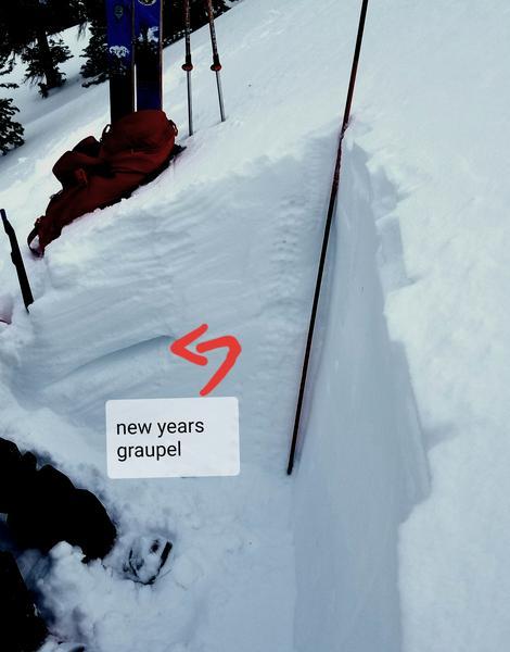
Dug at 7700ft on a protected north facing slope. Surprised to note a pretty distinct layer at the new/old snow interface. New year's layer was clear a bit farther down, with softer snow and graupel still present. Shovel tilt and shovel shear indicated good bonding in the new to old snow, as did the skiing in steeper terrain. Despite the F hardness sandwiched by 4F at the graupel layer, CT and ECT were both unreactive. Right side up snow otherwise.
Today's Observed Danger Rating
Low
Tomorrows Estimated Danger Rating
Low