Observation: Pleasant Creek

Observation Date
3/7/2019
Observer Name
John Pikus
Region
Skyline » Pleasant Creek
Location Name or Route
Pleasant Creek
Weather
Wind Speed
Calm
Weather Comments
Moderate snowfall at 7,000 ft when I started my tour at 3:45pm but it quickly stopped. Skies were obscured, then turning to broken, and finally to bluebird around 5pm. Winds were nonexistent even on ridgetops around 5:45pm.
Snow Characteristics
New Snow Depth
12"
New Snow Density
Medium
Snow Surface Conditions
Powder
Damp
Snow Characteristics Comments
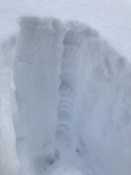
Below 8,400 feet there was 3-6 inches of complete glop. Probably the wettest snow I've seen yet this year. Despite a liberal application of skin wax at the start of the tour the snow stuck horribly to my skins and made uphill travel difficult. At 8,400 feet there was a sudden change to medium density snow. The new snow was slightly upside down, with a 2 inch deep capping of lighter density snow on top (see photo of hand pit below.) We toured the exact same route on Tuesday and noted the formation of thin crusts on NW, NE slopes, as well as a very thin zipper crust on lower angle N facing. Today I dug numerous hand pits which showed these crusts preserved with still damp snow below on WNW and NW facing. Hand shear tests released the new snow with moderate pressure an top of the crust layer. Also of note was that the top 2 inches of lighter density snow seemed poorly bonded to the denser snow below. Not a problem today and I would imagine it will settle out pretty quickly but maybe something to keep an eye on with additional snowfall forecasted for tomorrow.
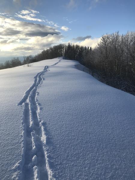
These density change layers seemed to be less present above 9,000 feet as snow depth increased and overall density got lighter. The Pleasant Creek area did very well with this last storm, seemed like at least a foot of new snow and probably more in places. Both our skintrack and ski tracks from Tuesday were completely covered up up high. I was surprised by the light density of the snow above 9,000 feet, I would put it on the light end of moderate. I was also surprised by the apparent lack of wind effect in areas I traveled considering the high recorded wind speeds overnight. New snow seemed well behaved for the most part, although it did want to sluff a little bit in steeper areas. It was also evident that some steeper areas had sluffed naturally during the storm.
On my exit the snow below 8,400 was already hardening up with the dropping temperatures.
Red Flags
Red Flags
Heavy Snowfall
Wind Loading
Red Flags Comments
Some wind loading was evident in the more exposed N-facing slide paths above Pleasant Creek. The old crown lines from the major Valentine's Day avalanche cycle are beginning to be filled in by wind drifted snow.
Avalanche Problem #1
Problem
Wind Drifted Snow
Trend
Same
Problem #1 Comments
As mentioned above, fresh wind drifts were visible on exposed N-facing slopes. Additionally, we had at least 4 inches of snow that fell with light to nonexistent winds, as evidenced by perfectly preserved snow on ridgetops. This could make it hard to detect the wind drifts in places.
Avalanche Problem #2
Problem
New Snow
Trend
Same
Problem #2 Comments
In this area new snow was deeper than expected and sits atop a melt-freeze crust on many slopes. Especially with more snowfall in the forecast would expect sluffing to be prevalent on steeper slopes.
Photo 1: Quick hand pit at around 8,700 feet on a WNW facing slope, about 30 degrees steep. Density change layers are visible. Was able to get all of the new snow to shear above the crust with moderate pressure.
Photo 2: Skintrack along the ridge, shows lack of wind effect in the most recent storm snow. This area has usually been pretty scoured this year.
Photo 3: Looking east towards the steep north facing slide paths above Pleasant Creek. The old crown line is visible, getting filled in with new wind drifts.
Comments
Toured in Pleasant Creek from elevations of 7,000 feet to 9,600 feet, predominantly on N, NW, and NE facing slopes.
Today's Observed Danger Rating
Considerable
Tomorrows Estimated Danger Rating
Considerable
Coordinates