Observation Date
2/10/2019
Observer Name
John Pikus & Zeb Engberg
Region
Skyline » Spring City Canyon
Location Name or Route
Sawmill Fork, Spring City Canyon, Knob Mountain
Weather
Wind Speed
Strong
Weather Comments
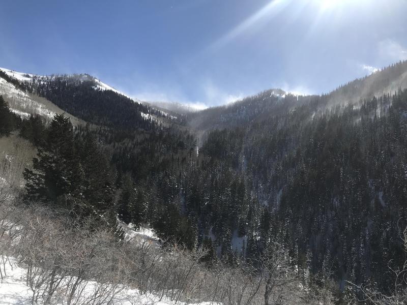
Very dynamic weather conditions today due to the incoming front. Skies were sunny until about 2pm, with strong and gusty SW winds above 9,000 feet. Winds were reaching well below ridgelines, see photo of numerous plumes reaching down into valleys. Around 2pm skies began to cloud up, and the winds shifted to SE for a short period, remaining strong. By 4pm skies were socked in and light snowfall had begun. Winds shifted back to SW and moderated quite a bit.
Snow Characteristics
New Snow Depth
2"
New Snow Density
Low
Snow Surface Conditions
Powder
Dense Loose
Wind Crust
Snow Characteristics Comments
Windslabs of varying densities were widespread over pretty much all aspects, especially north and east. Sheltered locations still harbored soft settled powder, with probably 2 inches of new snow from last night's system. Some south-facing slopes harbored a thin crust from yesterday, covered by the couple inches of new snow. The new snow that started falling late in the day was coming down as graupel.
Red Flags
Red Flags
Wind Loading
Cracking
Collapsing
Red Flags Comments
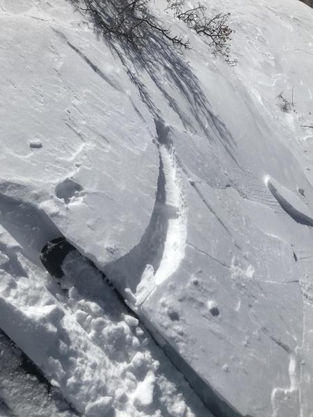
Evidence of wind loading was widespread. Experienced numerous incidents of wind slabs cracking and one major collapse on a wind-loaded slope.
Avalanche Problem #1
Problem
Wind Drifted Snow
Trend
Increasing Danger
Problem #1 Comments
Due to a variety of wind directions, wind slabs were evident on pretty much all aspects. SW, S, and SE slopes were mostly scoured but did show some evidence of cross-loading. Additionally, during the brief period of SE winds today we observed west facing slopes being loaded. We skinned up a SW facing slope that was mostly scoured on our first trip up but was sporting thin windslabs on our second lap. I would expect North thru East facing slopes to be the most problematic due to the dominant south and southwest winds over the last few days. The plumes coming off high ridgelines and loading north facing slopes have been visible from the valley over the past few days.
Comments
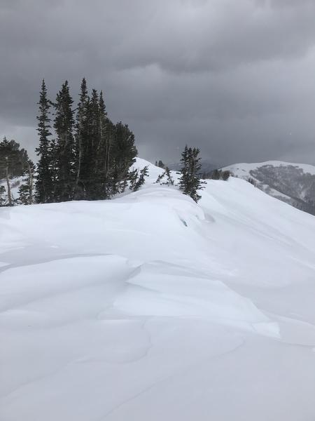
Toured in Sawmill Fork, Spring City Canyon, and Knob Mountain today from elevations of 6,500 to 10,500 feet. Wind has been cranking the last few days and was the dominant theme of the day. We did get a chance to view several high elevation, north facing slide paths and did not observe any signs of avalanche activity. That being said I think it is likely that the strong winds have reloaded these slide paths and obscured old crown lines. Cornices are growing, mainly above N and E facing slopes.
Photos:
1: Wind blowing plumes of snow well below ridgelines in Sawmill fork.
2: Shallow wind slabs cracking along our skintrack
3: Large cornices above an E-facing slope, with small W-facing cornice growing on top due to SE winds.
Today's Observed Danger Rating
Considerable
Tomorrows Estimated Danger Rating
High
Coordinates