Observation: Salt Lake

Observation Date
2/7/2019
Observer Name
B
Region
Salt Lake
Location Name or Route
Brighton Periphery: Snake Creek Canyon/Brighton Back Bowls/Figure 8/Patsy Marley
Weather
Sky
Overcast
Wind Direction
Northwest
Wind Speed
Moderate
Weather Comments
Overcast in the am, and clearing with Few in the pm. WNW winds were in the low end of the moderate category in the upper elevations, and wind blown and or transport was moderate with active loading above 9700. Temperatures were unseasonably bitter cold, especially in the wind.
Snow Characteristics
Snow Surface Conditions
Powder
Dense Loose
Wind Crust
Snow Characteristics Comments
Excellent settled powder in the protected mid elevations. Widespread wind damage and 4 finger plus slabs of up to at least 30 cm thick. Riding was challenging in the upper elevations with thick, slow dense wind laden snow. Snake Creek had dense riding in multiple layers of old wind slabs from the past three days. The bitter cold also played a factor in the slow riding conditions. The majority of the Back Bowl area was extremely dense with variable depths of wind slabs, and their hardness definitely was at least one finger to pencil in plaes.
Red Flags
Red Flags
Recent Avalanches
Wind Loading
Cracking
Red Flags Comments
Cracking observed in the wind loaded areas, and yet most of these were only cracking in the upper 4 to 6 cm. Most of the wind slabs outside of the Back Bowl area were only 4 finger plus.. See picture of slide off of Patsy Marley, and other reports indicate more widespread sensitivity than observed in the area traveled.
Avalanche Problem #1
Problem
Wind Drifted Snow
Trend
Decreasing Danger
Problem #1 Comments
See above and picture. Picture appears to indicate a cornice fall that triggered various depths of wind slabs upon decent.
Avalanche Problem #2
Problem
Persistent Weak Layer
Problem #2 Comments
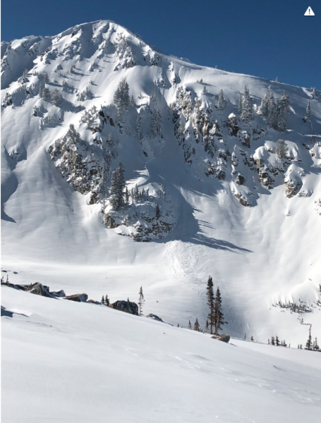
As indicated by the slide reported two days ago on 10420, lingering SH and or NSF's were still active recently in isolated locations. Other reports of deep avalanches in the past 72 hours indicate potential for Basal Facets as well as mid pack weak layer reactivity.
Wet Loose may be an issue in the lower elevations as well as on steep southerly facing aspects in the mid to low end of the upper elevations in the afternoon on Friday.
Large and sensitive cornices appear to be a concern.
With no naturals observed in area traveled the Danger was "High Consequence Moderate", yet other reports of wind loaded naturals appear to make it Considerable. With the SW winds forecast to escalate in the pm on Friday, Considerable most likely will be the call for Friday.
Today's Observed Danger Rating
Considerable
Tomorrows Estimated Danger Rating
Considerable