Donate to the 2024 Spring Campaign to help rebuild the UAC website.

Observation: Big Cottonwood Canyon

Observation Date
2/4/2019
Observer Name
Greg Gagne
Region
Salt Lake » Big Cottonwood Canyon
Location Name or Route
Big Cottonwood Canyon (Butler Fork/ Silver Fork/ Guardsman-10,420')
Weather
Sky
Obscured
Precipitation
Heavy Snowfall
Wind Direction
Southwest
Wind Speed
Moderate
Weather Comments
Periods of graupel through early afternoon, with heavy snowfall at times throughout the day. Winds were strong along 10,420' ridgeline, but in down low in Butler Fork (7200'), mid elevations in Silver Fork (up to 8500'), and down low in Guardsman area winds were light.
Snow Characteristics
New Snow Density
High
Snow Surface Conditions
Powder
Wind Crust
Snow Characteristics Comments
Dense storm snow, with ~15 cms of graupel. Storm ranges from 30-60 cms and very elevation dependent with highest totals above 9000'.
Quite a bit of graupel pooling below steeper slopes. The small slope below shows pooled graupel, and it is likely graupel has pooled below steeper slopes in avalanche terrain.
Red Flags
Red Flags
Heavy Snowfall
Wind Loading
Cracking
Poor Snowpack Structure
Avalanche Problem #1
Problem
Persistent Weak Layer
Trend
Increasing Danger
Problem #1 Comments
The old snow surface on non-solar aspects (northwest through east) was mostly near-surface facets, with some surface hoar found in Guardsman Pass area (other observers have noted this as well.) Below about 8500' a thin (2-3 mm) rain crust from this weekend capped the layer of near-surface facets. The storm snow bonded well to this crust, but the crust may provide enough strength to support a slab on top, with failures below this crust. All pits above 8500' were full propagation with ECT's, as well as two that failed and propagated upon isolation (ECTPV).
Although this slope is likely an outlier, on a NE aspect at 8700' in Silver Fork with HS 130 cms the slope had weak faceted snow down near the ground. Stability tests were getting failures in faceted snow closer to the surface, but this slope did provide insight there may still be some thinner snowpack areas (as well as repeaters) that may avalanche to the ground. (Drew Hardesty & Mark Staples had avalanching to the ground on Little Water Peak today - observation.)
Avalanche Problem #2
Trend
Increasing Danger
Problem #2 Comments
Winds were drifting snow and developing larger cornices. The wind drifts I encountered today were stubborn and not reactive, but the cornices were sensitive. Biggest concern with wind-loading on overloading slopes with preserved facets on the old snow surface.
Comments
Traveled in three different areas in Big Cottonwood Canyon to get an idea of low, mid, and upper elevation slopes:
Butler Fork - Low elevations (< 7500') was wet in top 45-60 cms of snow, but it looks like the water has drained sufficiently and with cooling, wet issues seem to be generally healed.
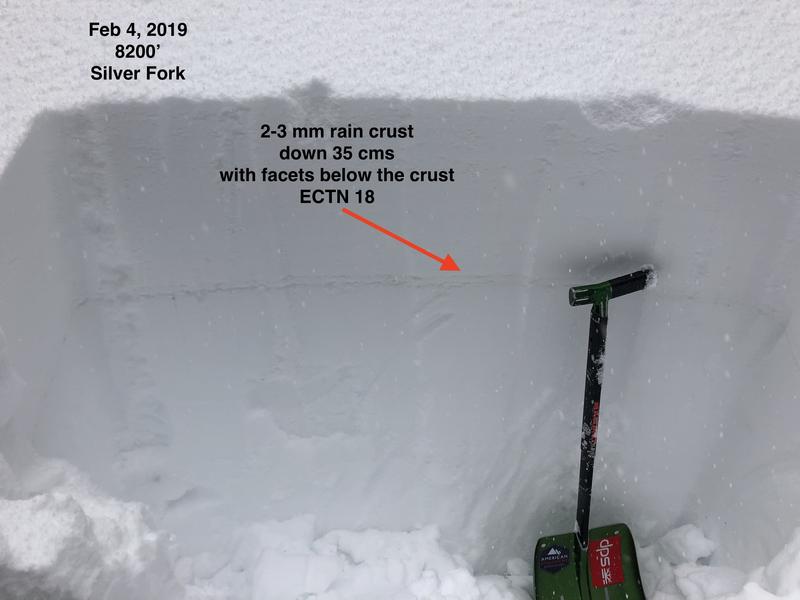
Silver Fork - mid elevations (< 9000) Thin rain crust capping a layer of near-surface facets found below about 8500' on non-solar aspects.
Between 8500' and 9000' was finding a layer of preserved near-surface facets, with a 30-40 cm storm slab on top. ECTPV (full propagation upon isolation)
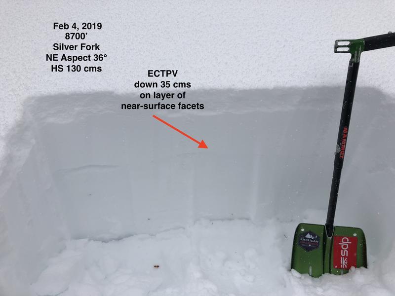
Selfie video of failure upon isolation
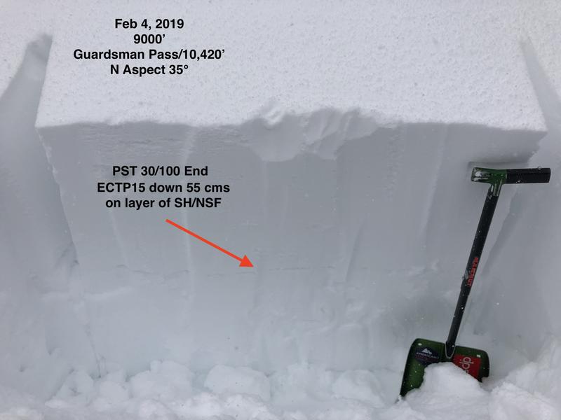
Guardsman Pass/ Peak 10,420' Area - (upper elevations) - Other observers have noted surface hoar in Guardsman Area, and I was finding evidence of it as well, including near-surface facets. Overall the SH I was finding was not really evident as I suspect it was destroyed somewhat, but the layer is an obvious 5-10 mm stripe down 30-60 cms. Full propagation with ECTs (ECTP15) as well as Propagation Saw Test - PST 30/100 End.
A juxtapose where you can use the slider of before and after ECTP results
Big take-home for me is that we have additional snowfall and wind in the forecast, so we'll likely be having storm snow and wind slab issues. However, the widespread preserved layer of near-surface facets and surface hoar I was finding on shady mid and upper elevation aspects facing northwest through east may be especially problematic, creating the possibility for remotely-triggered slides and larger avalanches that propagate widely. The hazard in both wind-drifted terrain as well as upper elevation terrain in Big Cottonwood Canyon that received the most snow (about 60 cms) was Considerable, and may be High by Tuesday.
Today's Observed Danger Rating
Considerable
Tomorrows Estimated Danger Rating
High