UDOT PLANNED AVALANCHE CLOSURES!!

Observation: Provo Peak

Observation Date
1/14/2019
Observer Name
Grainger, Dromgoole
Region
Provo » Provo Peak
Location Name or Route
Provo Peak
Weather
Sky
Few
Wind Speed
Moderate
Weather Comments
Clear skies with the inversion in full effect, completely obscuring the valley by mid-morning. Sustained but shifty Moderate-to-Strong SW, S, and SE winds throughout the morning with visible snow transport along ridges. Wind calmed by early afternoon save sporadic gusts.
Snow Characteristics
Snow Surface Conditions
Faceted Loose
Melt-Freeze Crust
Snow Characteristics Comments
Walked Rock Canyon up Provo Pk. to get a look at the snowpack before this week's precipitation. Wind and solar have been the main players in affecting the last storm snow.
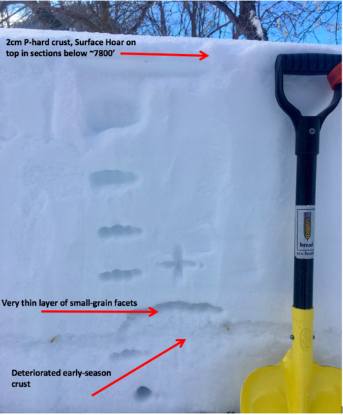
Lower elevations: Below ~7800' a F-to-K hard crust (0.5-2cm) formed on solar aspects and over the past week developed widespread NSF and isolated areas of Surface Hoar on top. This layer will be interesting to watch as storm snow falls this week and buries what remains of these persistent weak layers. Underneath the surface here much of the snowpack has settled and the deteriorated early season crust is the only notable layer in many locations. Small-grained facets that originally laid on this layer were unreactive in tests, 2 ECTX's and SSTH's that broke nonplanar within the crust 15cm from the ground in a HSn 68cm.
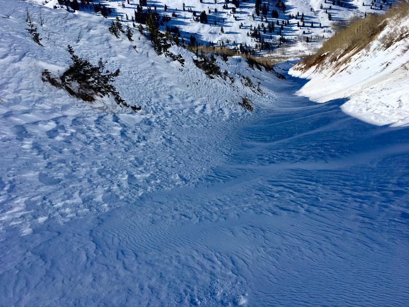
Upper Elevations: At this point nearly all terrain above ~9000' in this area is a product of wind scouring or wind deposit. Sastrugi, cross-loading, and hard ridgetop wind slabs made up much of upper Provo Peak and wind transport throughout the morning added to this. John Pikus's observed East Face slide crown had filled in and smoothed out with the Southerly winds and on the NW face downsloping wind hardened and textured the surface in all terrain down a few thousand feet. Here the danger of triggering one of these wind slabs, especially along the ridges where they are 10"+ and connected across wide loading zones, is still a possibility.
Red Flags
Red Flags
Recent Avalanches
Wind Loading
Cracking
Collapsing
Red Flags Comments
Isolated cracking and collapsing on small wind-loaded areas throughout the day. Very prominent plumes high on ridgetops as the southery winds did transport work through the morning.
Avalanche Problem #1
Problem
Wind Drifted Snow
Trend
Same
Avalanche Problem #2
Problem
Persistent Weak Layer
Trend
Increasing Danger
Problem #2 Comments
PWL could be a player when preserved NSF at all elevations and surface hoar on lowers are buried by this storm snow. Places with the thermal crust and SH on top will make reactive sliding surfaces.
Comments
Lower elevation profile, 7000'. ECTX and SSTH within the deteriorated crust.
Wind effect even in protected gully features. Cracking and collapsing on the small crossloaded pillows.
Inversion by mid-morning. Solar effect has diminished much of the snowpack on south through west faces mid and low elevation.
Today's Observed Danger Rating
Moderate
Tomorrows Estimated Danger Rating
Moderate
Coordinates