Observation: Skyline

Observation Date
12/11/2018
Observer Name
Kobernik - Kendall
Region
Skyline
Location Name or Route
Numerous locations from Reeder Canyon to Blue Slide Fork
Red Flags
Red Flags
Poor Snowpack Structure
Red Flags Comments
The weak sugar snow near the ground in the higher northerly facing terrain has gained strength but is still a bit of a concern.
Avalanche Problem #1
Problem
Persistent Weak Layer
Trend
Decreasing Danger
Problem #1 Comments
The only concern right now is the old sugar snow near the ground on the higher northerly slopes. The snowpack is definitely more stubborn at this point. I have not experienced any "whoomping" or collapsing of the snowpack since Friday. I have not seen any recent avalanche activity. Furthermore, as I travel around and look at many slopes that are the usual suspects, not many avalanched during the last storms. I came across a small slab avalanche in Reeder Canyon on a north facing slope. The fracture line was mostly filled in. I also came across a similar one in Pleasant Creek today. Same deal, fracture line somewhat filled in so it's difficult to figure out when exactly it released. Overall, the snowpack is going in a good direction. That said, I'm still getting the old sugar snow to fail with full propagation in snowpit tests. Scores for ECT tests are generally in the mid 20s. Even though the results are stubborn, I will feel better when I'm not seeing clean fractures and full propagation in the tests.
Video
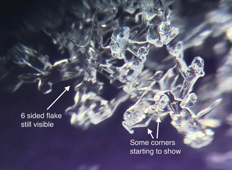
There has been a little sugar snow (near surface faceting or recrystalization) starting to form in the top few inches of the snowpack. At this point, it doesn't seem too alarming and my guess is it won't be an issue once it gets buried. Looking at the grains under a scope reveals some corners starting to show up which is the start of the sugary snow. However, you can also still make out remnants of 6 sided snowflakes which tells me that the near surface faceting process hasn't turned the surface snow to complete sugar just yet. If we get a few inches of snow out of Wednesday's storm, this will help arrest any further sugar snow development in this layer.
Today's Observed Danger Rating
Moderate
Tomorrows Estimated Danger Rating
Moderate