Fall Auction is now live! Check it out now

Observation: Gobblers

Observation Date
2/24/2018
Observer Name
Greg Gagne
Region
Salt Lake » Big Cottonwood Canyon » Mill Creek Canyon » Mill A » Butler Fork » Gobblers
Location Name or Route
Millcreek Canyon (Mount Raymond/Gobblers Knob)
Weather
Sky
Overcast
Precipitation
Light Snowfall
Wind Direction
Southwest
Wind Speed
Moderate
Weather Comments
Moderate winds along Mount Raymond and Gobblers ridgelines. Cloud deck lowering in the afternoon, with light snow developing.
Snow Characteristics
New Snow Depth
5"
New Snow Density
Low
Snow Surface Conditions
Powder
Wind Crust
Snow Characteristics Comments

Friday storm did not favor Millcreek with ~10 cms (3-5").

Still, a decent snowpack developing with the following snowpack depths (HS)

9500' NW aspect Mount Raymond 1.5 meters

9800' SE aspect Mount Raymond 90 cms

9800' NW aspect Gobblers Knob 130 cms

​Winds have scoured the upper west face of Gobblers creating the usual thin spots. We were finding wind-affected snow halfway down west-facing Cabin Run.

Red Flags
Red Flags
Recent Avalanches
Wind Loading
Poor Snowpack Structure
Red Flags Comments
Noticed boarder triggered avalanche on SE aspect of Mount Raymond.
Avalanche Problem #1
Problem
Wind Drifted Snow
Trend
Increasing Danger
Problem #1 Comments

Were finding pockets of sensitive shallow wind drifts that are sitting on top of low-density stellars from Friday, as well as decomposing fragments (DFs) from Monday's storm. Not enough loading today for this to be a widespread problem, but Saturday night/Sunday am storm system looks windy.

Avalanche Problem #2
Problem
Persistent Weak Layer
Trend
Increasing Danger
Problem #2 Comments

Am finding a layer of mid-pack faceted snow down ~70 cms (28") in Porter Fork. Storm snow from the past two weeks goes from F down to 4F hard, but all tests have been ECTN or ECTX (not propagation.) With enough of a load (storm snow and/or wind), am thinking this layer of mid-pack facets may become reactive at some point.

Comments

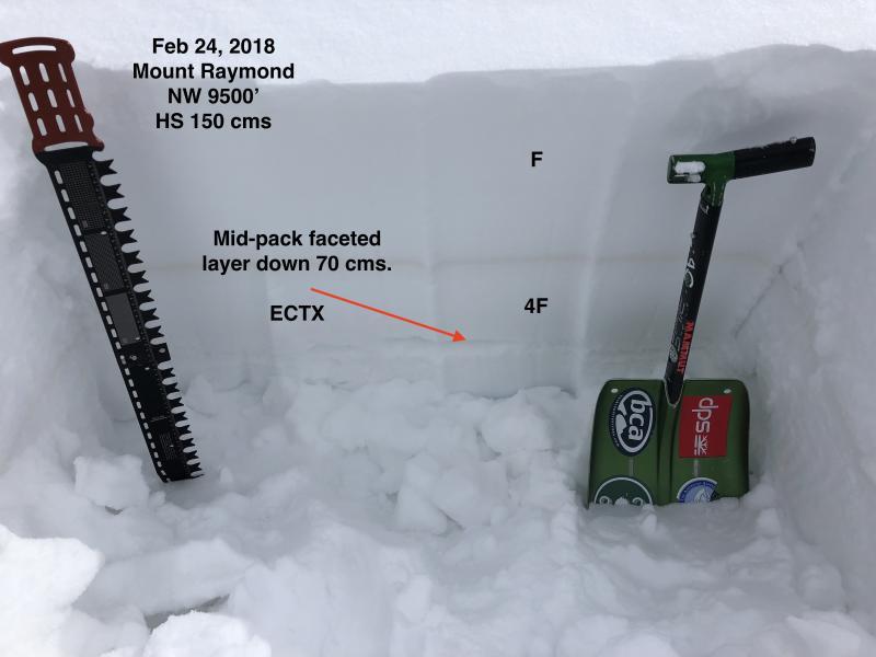
Covered some ground today to get a better sense of snowpack on Mount Raymond and Gobblers zones. Raymond Glade, SE aspect of Raymond shoulder, up Gobblers Knob summit ridge with Cabin Run exit. General snowpack structure shows evidence of stability, but am finding mid-pack facets as well as weak snow down near the ground. Currently the snowpack has seemed to adjust to recent loading, but avalanches earlier this week on Gobblers Knob (Davis Gulch and Toot to Boot) that failed on persistent weak layers are indicators these weaknesses may become reactive again with additional loading.

The top 15 cms (6") of the existing snow surface contains very light stellars as well as DF's and am thinking this will initially be the weakest layer with additional storm snow and wind-loading.

Photo showing mid-pack faceted layer.

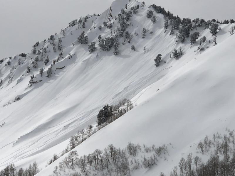
Ran into a group of boarders coming from Butler Fork and they were the apparent triggers of a slide we later saw on SE aspect on Mount Raymond. Unsure if this was a wind or storm slab.

Lower exits on Gobblers are still not prime time.

Moderate hazard today (but would not have skied several lines where there is a poor snowpack structure) and easily Considerable on Sunday with expected storm totals and wind.

Today's Observed Danger Rating
Moderate
Tomorrows Estimated Danger Rating
Considerable