The small amount of snow that is coverning the Manti Skyline changed significantly during this past week. In simple terms, the colder weather that moved in on Monday, Dec 4th transformed the shallow snowpack into very loose sugary grains. These faceted (sugary) grains will most likely be a concern once we see more snow stack up on top of them at least on the highest more northerly facing slopes.
The good news is that a lot of the terrain out there doesn't have a significant enough amount of snow yet. This means that even though there may be a few inches of very weak snow covering the ground, it probably won't be enough to act as a widespread persistent weak layer on the east, south, and west facing slopes.
TECHNICAL INFORMATION:
Snow temperature measurements from over the last week paint the picture. My weather station at 9600' in Spring City Canyon has an infrared thermometer that very accurately measures the temperature of the snow surface. There was 12cm of snow at the weather station. Knowing that the ground is always right about 0˚C, we can calculate the temperature gradient from the ground to the snow surface. When the gradient is steep (big difference in temperatures), this promotes significant facet growth. Below is a chart of the snow surface temperature (blue line) and the temperature gradient (red line).
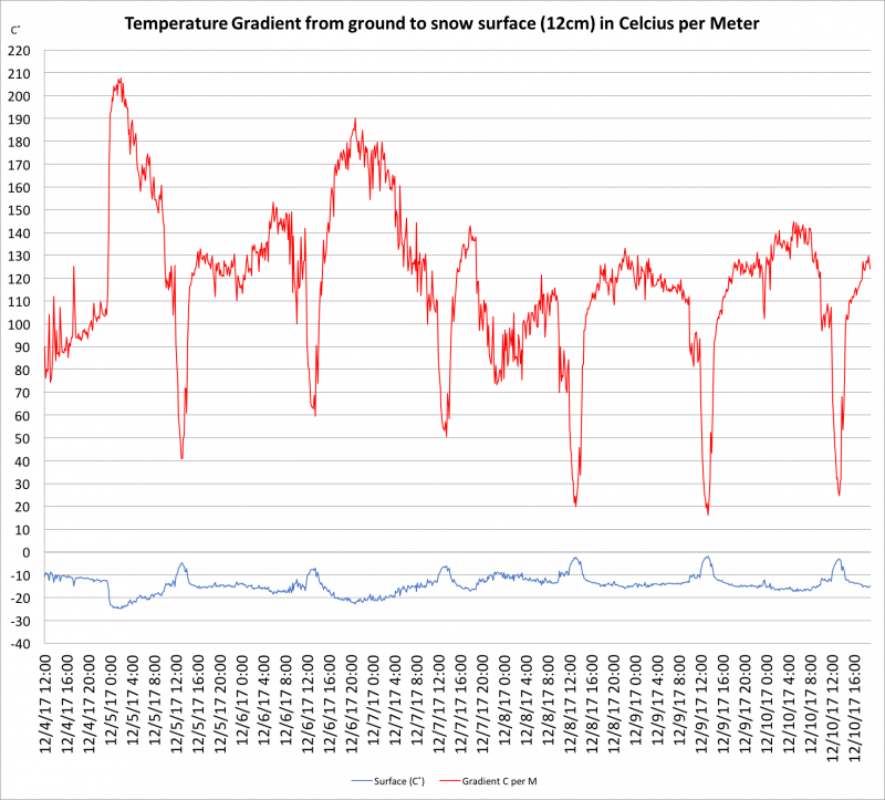
What is significant about this chart is that it shows the snow surface temperature becoming very cold (below -20˚C) for periods on the night of the 4th and 6th. Temperature gradients were also VERY steep during these periods. Max gradients were almost 210˚C per M (or 21˚C per 10cm). Fairly steep gradients remained in place for most of the week. It is no wonder that the snow has turned into sugary faceted loose grains.


