Get Your Ticket to the 32nd Annual Backcountry Benefit on September 11th! Support Forecasting, Awareness, and Education

Observation Date
4/8/2017
Observer Name
Joey Dempster
Region
Provo » Provo Canyon » Timpanogos » Primrose Cirque
Location Name or Route
Primrose Cirque
Weather
Sky
Overcast
Precipitation
Light Snowfall
Wind Direction
Southwest
Wind Speed
Strong
Weather Comments
Rain, then heavy snow, then high winds. The first part of the storm packed a decent punch, and there were debris piles everywhere to prove it. Drier snow up high was being transported by the afternoon high winds. Lots of spindrift pouring down off of Robert's Horn and East Peak.
Snow Characteristics
New Snow Depth
4"
New Snow Density
High
Snow Surface Conditions
Dense Loose
Melt-Freeze Crust
Damp
Snow Characteristics Comments
I topped out at 9000', and even at that elevation, the old snow surface was saturated down 6"-8". The top of that layer is in the process of refreezing, but is not yet supportable. On top of that is 3"-4" of very dense "sierra cement" up to about 8000 feet at which point it gradually changes to slightly drier "styrofoam". I thought the descent was going to be forgettable at best because of the breakable crust under the new snow, but with fat rockered skis, it actually skied quite well, and I'd go back and do it again without reservation.
Red Flags
Red Flags
Recent Avalanches
Heavy Snowfall
Wind Loading
Poor Snowpack Structure
Red Flags Comments
I saw moderately large debris piles (by Primrose standards) under every major slide path. The debris looked chunky like a wet slab, and there was a few inches of snow on all of them, so I assume they ran during the first part of the storm. (Forecaster note: timing of these slides is unknown.) As mentioned above, I found saturated snow up to 9000 feet, so it seems likely that it rained even higher than that, and the rain caused the avalanche cycle. Once things cooled down and it started snowing, I believe that this particular hazard abated, but still the saturated snow in the top 12 inches of the snowpack is a red flag. It's hard to say what it will do tomorrow, as it will depend on temperatures overnight and how much new snow falls. But it is safe to say that the new snow will be falling on a complicated upper snowpack, which is cause for concern. Also, the winds were quite strong, and although there might not have been a lot of dry snow to blow around, and transport was restricted to the highest elevations (up to 9000' the snow surface was too dense to be blown around), there could be wind slabs up high.
Avalanche Problem #1
Problem
Wind Drifted Snow
Trend
Same
Problem #1 Comments
Wind slabs from Saturday will be confined to the highest elevations. Probably manageable. Moderate hazard.
Avalanche Problem #2
Problem
New Snow
Problem #2 Comments
The new snow that fell after the changeover from rain to snow is warm and dense, and should provide an excellent bonding surface for new that falls Saturday night and Sunday morning. If that were the only factor, I would say hazard tomorrow would be moderate, perhaps even low. However, the wild card is the saturated snow underneath the 3"-4" of new snow. The saturated snow is quite weak and uncohesive. It has the advantage of having quite a bit of friction, and with a small load on top of it today, there were no signs of instability, either slab or point release. But with an additional significant load on top of it, I would approach it with caution, since it's an unfamiliar structure.
It is possible that enough heat will be drawn out of the saturated portion of the snow back that it will become supportable. If this happens, I would expect stability to be excellent tomorrow.
Comments
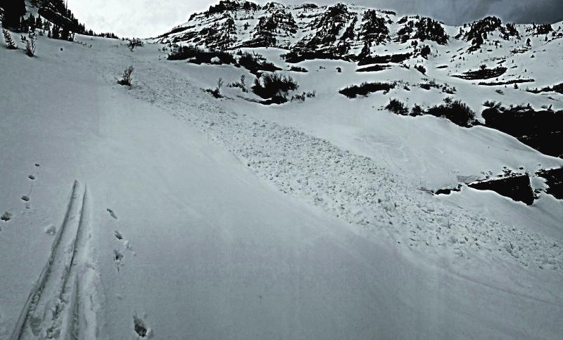
The photo below is one of the debris piles in Primrose that ran early Saturday morning. (Forecaster note: timing of these slides is unknown.) This one is significant because it was part of a larger avalanche that ran down from the high cliffs of east peak down towards the Falls Couloir. Normally, all of the debris gets channeled into the couloir. In 20 years of skiing in Primrose, I don't recall seeing this much of that path's flow diverted down into the small bowl to climber's right of the Falls Couloir (That's not to say it has never happened, just that it's not frequent enough for me to have noticed). I interpret this to mean that these types of avalanche paths are so deeply filled with debris that it is potentially causing debris flow that is out of the ordinary. So caution is warranted in areas that you might normally consider out of the runout zone for large avalanche paths. It is difficult to say whether the weakness that caused this cycle Friday night into Saturday is still present, and could reload with new snow, or if it got washed out or perhaps cooled down enough that the new snow will not produce a similar cycle tomorrow. It would be prudent, I think, to assume that the weakness will persist and give these big paths a wide berth tomorrow.
Today's Observed Danger Rating
Moderate
Tomorrows Estimated Danger Rating
Moderate