Observation Date
1/12/2017
Observer Name
Dave Garcia
Region
Moab
Location Name or Route
Laurel Highway
Weather
Sky
Overcast
Precipitation
Heavy Snowfall
Wind Direction
Southwest
Wind Speed
Strong
Weather Comments
I'm starting to sound like a broken record here, but winds were once again strong out of the southwest. Winds were light to moderate below tree line, but they were nuking on the ridge lines. Total whiteout up high. Snowfall was light at the TH but was falling heavily above tree line. Mid and upper elevations seemed to be getting moderate to heavy snow for most of the day as my tracks were filled in on the second lap. For sure more than 1 inch per hour up high. And at the end of the day snowfall was even moderate at low elevations. I think we can count on some good accumulation for tomorrow (Friday).
Snow Characteristics
New Snow Depth
6"
New Snow Density
Low
Snow Surface Conditions
Powder
Dense Loose
Wind Crust
Snow Characteristics Comments
Snow totals down low were only about 2 inches, but up high there was already about 6 inches of new snow. It felt like pretty low density snow to me, the skiing in sheltered spots was quite good and only getting better as the day progressed.
Red Flags
Red Flags
Heavy Snowfall
Wind Loading
Red Flags Comments
Wind loading was once again the biggest red flag observed. High elevation slopes facing NW through E were being rapidly loaded today. We are finally seeing some real snow start to fall up there and this will lead to increasing danger as well. Over the course of this storm, or series of storms since about 1/4/17, we have not seen any big snow totals over a 24 hour period. We have also not seen any big obvious red flags like avalanching, cracking, collapsing, and whoomphing. I think the low snow totals are a big reason we are not seeing the obvious red flags, but this could change heading into tomorrow.
Avalanche Problem #1
Problem
Wind Drifted Snow
Trend
Increasing Danger
Problem #1 Comments
The most pronounced avalanche danger right now will be due to the wind. Wind slabs have been piling on top of each other of the lee side of the ridges for several days now. These old slabs are very deep and stiff right now. This makes them hard to trigger, but could result in large slides. Fresh drifts were once again forming today and these should be avoided. As I walked the ridge above Horse Creek today the new drifts were cracking at my feet, but were much softer than the wind slabs noted in my 1/10 observation. Wind loading was most obvious on slopes facing NW through E. I crossed a wide open west face and did not encounter new wind slab there.
Avalanche Problem #2
Problem
Persistent Weak Layer
Trend
Same
Problem #2 Comments
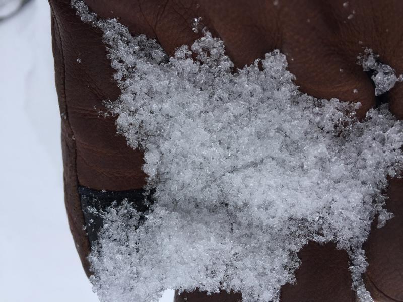
As Eric has noted there is now buried faceted snow and a variety of crusts on all aspects. You will find this problem on most aspects at mid elevations and higher. On a positive note I had good results while testing a 30 degree upper elevation slope facing NW. The suspected weak layer (graupel facet mix 35cm below the surface) proved to be stronger than expected. On the first compression test it took a lot to make it fail (CTH 24 Q3). I conducted a second compression test on the same layer with no failure the second time. Good news there. However things are really varied right now. Take a look at the photo below of some rather large facets sitting below 8 inches of slab on a mid elevation SW facing slope. Bottom line with persistent slab right now is things are pretty variable and if you are skiing in avalanche terrain grab the shovel and look for that persistent weak layer.
Comments
With the lack of big obvious red flags today I am tempted to call todays danger moderate. But with the heavy snowfall and continued winds in the forecast, tomorrow (Friday) could bump back to considerable.
These large facets were found on a mid elevation SW facing slope beneath 8 inches of dense slab material. No need for a lens to see just how large and angular these crystals are.
Today's Observed Danger Rating
Moderate
Tomorrows Estimated Danger Rating
Considerable