Observation Date
12/26/2015
Observer Name
Patrick Fink
Region
Salt Lake » Big Cottonwood Canyon » Mill D North
Location Name or Route
Mill D North
Weather
Sky
Few
Wind Direction
North
Wind Speed
Moderate
Weather Comments
Moderate ridge top winds from the North, with significant wind transport onto the top 30 meters of Southerly slopes. Sun became a factor on South facing slopes around 1pm, making the snow surface heavy despite low air temps. Small point releases in the new snow were observed along the BCC road on the way home.
Snow Characteristics
New Snow Depth
5"
New Snow Density
Low
Snow Surface Conditions
Powder
Dense Loose
Wind Crust
Snow Characteristics Comments
Sheltered areas away from ridges hold good riding conditions. Near the ridges the wind has increased density and reduced depth on South facing slopes. Northerly winds were forming a medium-density wind slab near the ridge top.
Red Flags
Red Flags
Recent Avalanches
Wind Loading
Cracking
Collapsing
Rapid Warming
Poor Snowpack Structure
Red Flags Comments
Recent avalanches-- observed activity was ~2d old. Could see the N'ly Powder Park slab reported here previously (one group was skinning the hangfire and skiing adjacent slope).
Wind load-- From the North, reversing recent trends. Small wind slabs forming near ridges.
Cracking/Collapsing-- One collapse at the sheep shit ridgetop. Shooting cracks running through freshly formed wind slab.
Avalanche Problem #1
Problem
Persistent Weak Layer
Trend
Decreasing Danger
Problem #1 Comments
The basal facet problem seems less touchy today. Fewer collapses observed, and less punching-through to low density snow while breaking trail. We stayed conservative on angle and didn't dig a pit, so this is conjecture, but I suspect bridging in the storm snow is to thank for this. That just means that this problem is harder to trigger, but the facets should heal more slowly. It's becoming a Dragon in the Basement.
Avalanche Problem #2
Problem
Wind Drifted Snow
Trend
Increasing Danger
Problem #2 Comments
This is divided into both the North and the South halves of the compass. Northerly slopes, even those that ripped during the storm, are loaded with buff looking windslab. Today, wind slab was forming in Southerly terrain. This was not a huge concern in the low angle terrain of Mill D, but in the right place these could be sensitive and provide the oomph to step down into the deeper slab.
Problem 3: Warming. Even today the sun was having an effect, and with warmer temps tomorrow, this will be a concern.
Comments
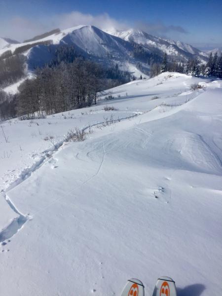
Cracking within the new wind-transported snow in the near field, with the Little Water Pk avalanche in the background. Note winds from the right (North) transporting snow onto S'ly aspect.
I'm torn on the danger rating. Most south facing terrain is moderate danger, but the consequences of trigger a deeper slide are significant, so I'm sticking with considerable.
Today's Observed Danger Rating
Considerable
Tomorrows Estimated Danger Rating
Considerable