Route this morning was up Grizzly Gulch and cruised Patsy Marley ridgeline with the intention of skiing E-facing aspects down off Twin Lakes Pass ridgeline to Figure 8 hill. Poor stability on the way up the ridgeline changed that thinking. Using quick hand pits on north aspects I was finding a poor bond of the storm snow to the old snow surface and was unable to isolate a column. Also was finding at least one density inversion within the storm snow. Very easy to get the storm snow to crack, especially on steeper aspects. Along the N/NE facing ridgeline I was finding fresh sensitive cornices as well.
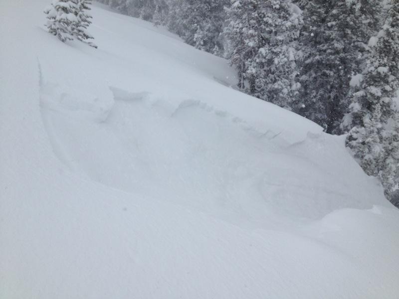
Noted a natural avalanche on NE aspect at 9800' (PHOTO) and when I went down to examine the likely weak layer I remotely triggered the adjacent slope. Both the natural and remotely triggered slides were Class 1, 20 cms thick, failing at the old snow/new snow interface. They were both about 8 meters (25') wide and ran at least 30 meters (100'). Further along the ridgeline I was kicking a cornice on a test slope and got the test slope to spider web, but this sympathetically triggered a Class 2 slide where the slope steepened. This ran on the same weak layer, but was at least 50 meters wide and ran perhaps 75 meters as well (though poor visibility limited the accuracy of this.)
The weak snow I was finding on northerly aspects appeared to be either some NSF's or DF's. (Near-surface facets in the Wasatch in late April? Kobernik - where are you? I need to talk facets.) Regardless, a weak layer was present on northerly aspects and the storm snow was overloading it.
On SW-S aspects I was finding things more stable, with some cracking in the storm snow. On these solar aspects there is a 5 cm thick MF crust with dry snow underneath. The storm snow had bonded well to this crust, but there was a density inversion in the storm snow which provided a clean, failure plane with quick hand pits.
Things change so rapidly this time of year, and clearly the biggest concern will switch to warming from the sun. I suspect SW-SE aspects will behave predictably with wet slides, although there are several layers on these aspects and some wet slides may step down to one of these deeper layers. I wouldn't be surprised to see some large wet slides on Sunday.
Northerly aspects may be interesting ...... we often hear "unusual weather causes unusual avalanches" and this past week we had several storms depositing modest amounts of light, dry powder that has been preserved on northerly aspects due to unseasonably cold temperatures. The NSF layer I was finding today is something I consider unusual for this time of year and I wonder if northerly aspects might quickly become unstable once they warm due to the persistent weak layer. Hypothesizing here and honestly don't know as I am not that familiar with this situation this late in the season. Additionally, the wind slabs may stabilize somewhat laer in the day on Saturday, yet might become active once they warm on Sunday.
Hazard this morning on steep, upper elevation wind loaded slopes (primarily NE-SE) was Considerable at a minimum, and possibly even pockets of High.