The first order of business on my mind was how the current snow surface will react with additional layers as we anticipate a storm system moving in on Thursday. I've been watching the surface deteriorate rapidly over the last week but I was not out in the hills on Monday. I've had temperature sensors deployed in a few locations since the 3rd and anticipated when I retrieved them today the surface would have at least medium grained facets at the 7500' NE location of the sensors. I was somewhat surprised that the surface was not as loose as I anticipated it would be. It appears that warm temperatures over the last few days have disrupted the faceting process and perhaps even reverted some of these grains to a more favorable form. I did not experience the amount of sluffing on steep slopes as I did a few days back and I also noted that my skins were not slipping as much.
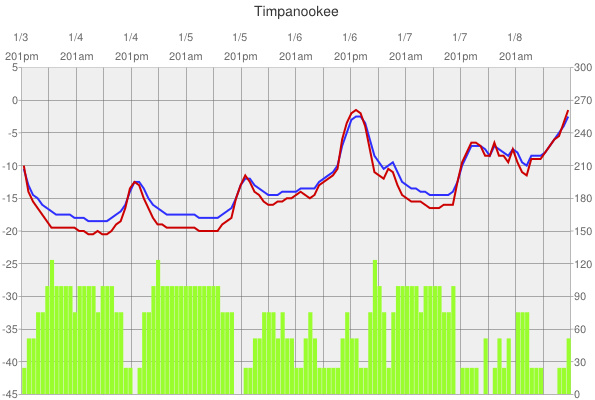
The dataset from the sensors somewhat backs this up. You'll note strong gradients (green bars read on right in C per M) on the 3rd and 4th and 5th but they become less as things warm up toward the end of the period.
I intend to visit a few places that I visited a number of days ago where I thought things were quite loose on the surface and were cause for concern with an additional load. I'm curious if I will still feel the same after these couple of warmer days.
Other things to consider with the upcoming storms are still the thinner snowpack areas where the pack is either a) rotton from the ground to the surface or b) still have some weakness associated with the December rain crusts.
This recent riming event throws in another wild card. Bottom line: We'll need to do our homework after the next layer of snow to see how things are reacting before getting back into the big slopes.


