Get Your Ticket to the 32nd Annual Backcountry Benefit on September 11th! Support Forecasting, Awareness, and Education
icon-add
Observation
Menu
×
Menu
Forecasts
Logan
Ogden
Salt Lake
Provo
Uintas
Skyline
Moab
Abajos
Weather
Archives
How to read the forecast
Observations & Avalanches
Submit Observation
Observations Explorer
All Observations
Avalanches
Fatalities
Weather
Place Names Map
Archives
Education
Avalanche Class List
UAC Class List
Online Classes
Resources and Tutorials
Avalanche Awareness
Develop Skills
Events
Store
About
Contact
Who we are
Core Values
Staff
Board of Directors
Past Forecasters
Sponsors
Annual Reports
Sign In
Blog
Donate / Join
Search
Forecasts
Logan
Ogden
Salt Lake
Provo
Uintas
Skyline
Moab
Abajos
Weather
Archives
How to read the forecast
Observations & Avalanches
Submit Observation
Observations Explorer
All Observations
Avalanches
Fatalities
Weather
Place Names Map
Archives
Education
Avalanche Class List
UAC Class List
Online Classes
Resources and Tutorials
Avalanche Awareness
Develop Skills
Events
Store
About
Contact
Who we are
Core Values
Staff
Board of Directors
Past Forecasters
Sponsors
Annual Reports
Sign In
Blog
Menu
Search
icon-add
Observation
Donate / Join
Submit Observation
Observations Explorer
All Observations
Avalanches
Fatalities
Weather
Place Names Map
Archives
Submit Observation
Observations Explorer
All Observations
Avalanches
Fatalities
Weather
Place Names Map
Archives
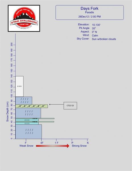
Observation Date
12/28/2012
Observer Name
Paradis
Region
Salt Lake
Location Name or Route
Days Fork
Weather
Sky
Clear
Precipitation
Light Snowfall
Wind Speed
Calm
Weather Comments
Started off the morning with a few snow showers then gradual clearing as the day went on. Cool temperatures all day.
Snow Characteristics
New Snow Depth
16"
New Snow Density
Low
Snow Surface Conditions
Powder
Snow Characteristics Comments
Great low density powder. There were a few slightly denser drifts on the ridges but in general the snow had little wind affect.
Red Flags
Red Flags
Heavy Snowfall
Red Flags Comments
Nearly two feet of new snow from Wednesday & Thursday plus more earlier in the week. Snow was low density and not slab like which helped.
Avalanche Problem #1
Problem
New Snow
Problem #1 Comments
The quick pit below was dug close to the ridge that divides Upper Days and Main Days and is not generally representative. The snow here is likely thinner than in the center of either run. I chose this location because it was adjacent to a small slide (~ 25ft x 50ft) triggered the prior day from the uptrack. Compression tests produced results on the denser wind slab from the wind event last week. I didn't look at starting area so it wasn't 100% clear to me if this was a factor in this slide or if it was on the interface from this storm and the christmas eve storm. Forgot to take a picture.