Get Your Ticket to the 32nd Annual Backcountry Benefit on September 11th! Support Forecasting, Awareness, and Education

Observation Date
12/20/2012
Observer Name
Greg Gagne and Dave Pease
Region
Salt Lake
Location Name or Route
Mineral Fork
Weather
Sky
Clear
Weather Comments
-7C @ 9300' @ 10 am. Some plumes from SW winds observed off of highest ridgelines. Calm and windless where we traveled.
Snow Characteristics
Snow Surface Conditions
Dense Loose
Faceted Loose
Wind Crust
Snow Characteristics Comments
Some faceting as well as surface hoar noted in the top few cms of snow. A few thin old windboards were also noted. In some places, the wind scoured all the new snow down to the 2-3 cm thick rain crust leaving total snow depths at about 30 cms (12"). For the most part, observed snow depths ranged from 60-90 cms (2-3')
Red Flags
Red Flags
Poor Snowpack Structure
Red Flags Comments
This drainage had the weakest snowpack structure I have observed this season - weaker than upper LCC, Millcreek, as well as a few other drainages in BCC. Did get one collapse on NE aspect at 9000'
Avalanche Problem #1
Problem
New Snow
Trend
Same
Problem #1 Comments
Was finding 2 rain crusts buried anywhere from 15 cms (6") to 45 cms (18"). Top crust is very thin & brittle - often difficult to identify. Bottom crust is stout and 2-3 cms thick with an ice lens. Facets below lower crust appear weaker than faceted layer between crusts, likely because the lower crust forms a vapor barrier and upper crust does allow some vapor transfer. (Keith Stebbings identified something similar I believe near Brighton.) ECTP20 down 40 cms (below lower crust.)
Snow Profile
Aspect
North
Elevation
9,300'
Slope Angle
30°
Comments
Quite a bit of spatial variability observed today. For the most part, was finding a generally thin snowpack up to 9500' with snow totals roughly between 60-90 cms (1.5-3'), although quite often on the lower end. On one ridgeline running east-west there was little evidence of much wind affect, on an adjacent ridgeline was finding the snow surface scoured down to late November rain crust. Was finding a very stout 2-3 cm rain crust with ice lens up to about 9300'. I have not observed this stout crust at these elevations in the tri-canyon area this season. First video shows results of ECT failing below lower rain crust.
Video
This video shows the weak, faceted snow where the ECT fractured.
Video
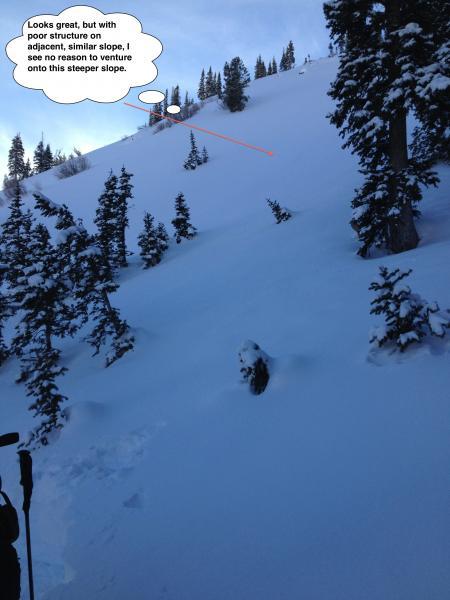
Excellent skiing/riding/travel conditions in this beautiful low light at the Solstice. This slope was unskied, but with poor snowpack structure, am not seeing a reason to stick my neck out on steeper slopes.
Coordinates