Get Your Ticket to the 32nd Annual Backcountry Benefit on September 11th! Support Forecasting, Awareness, and Education

Observation Date
12/15/2012
Observer Name
Jonathon Spitzer
Region
Salt Lake
Location Name or Route
Cardiff Fork & Mineral Fork
Weather
Sky
Overcast
Precipitation
Light Snowfall
Wind Direction
Southwest
Wind Speed
Light
Weather Comments
Light snow showers during the day with a few periods of moderate showers. Visibility varied with fog at times. Winds increased throughout the day.
Snow Characteristics
New Snow Depth
12"
New Snow Density
Low
Snow Surface Conditions
Powder
Snow Characteristics Comments
Snow surface stayed cold during the day. No real slab even at Cardiac Ridge in the new storm snow. New snow did sluff (D1)
Red Flags
Red Flags
Heavy Snowfall
Poor Snowpack Structure
Red Flags Comments
Snowpack structure varies greatly from terrain, elevation, and aspect. Fair structure on E aspect (Cardiac Ridge), while Poor structure on N facing terrain in Mineral Fork.
Avalanche Problem #1
Problem
New Snow
Trend
Increasing Danger
Problem #1 Comments
Only a matter of time! Poor snowpack structure on North aspects around treeline.
Avalanche Problem #2
Problem
Persistent Weak Layer
Trend
Increasing Danger
Problem #2 Comments
Increasing forecasted winds could create a problem in short term future with all the fresh light density snow.
Comments
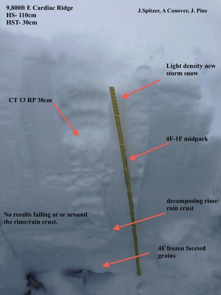
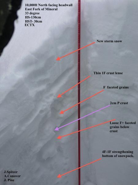
Snowpack varies greatly with aspect, elevation and terrain feature. Lots of variability out there. I personally would be aware of areas that have preserved the persistent weak layers. Especially areas that have faceted grains above and below the rime/rain crust. I think the snowpack is stubborn and bonding tests like ECT's and CT don't allows equate to the poor snowpack structure we have. Side note: very few people in Cardiff Fork. I would expect to see a size-able avalanche cycle with the forecasted winds and water weight. Thanks to Allison and Jen for a good tour.