Get Your Ticket to the 32nd Annual Backcountry Benefit on September 11th! Support Forecasting, Awareness, and Education

Observation Date
12/14/2012
Observer Name
Paradis / Caplis
Region
Salt Lake
Location Name or Route
Georges Bowl
Weather
Sky
Clear
Wind Speed
Calm
Weather Comments
Sunny most of the day but light snow started at about 2pm.
Snow Characteristics
New Snow Depth
5"
New Snow Density
Medium
Snow Surface Conditions
Powder
Snow Characteristics Comments
New snow from last weekend has been wind affected, particularly in more exposed areas. In more protected areas, the snow was in good shape.
Red Flags
Red Flags
Poor Snowpack Structure
Red Flags Comments
We didn't observe any avalanches or collapsing, although the snow from last weekend is now a wind slab sitting on several crusts, that are sitting on facets from November. Seems like lots of opportunity for things to go wrong.
Avalanche Problem #1
Problem
Persistent Weak Layer
Problem #1 Comments
Strong winds from earlier this week have created a slab above crusts from earlier in the month. In snowpit tests, the upper most rain crust produced results and could be a potential bed surface.
Snow Profile
Aspect
North
Elevation
9,300'
Slope Angle
22°
Comments
Compression tests consistently produced results in the teens on the upper most rain crust. Shear quality was good & clean although the snow did not show much energy. Our ECT results were less obvious and had lower quality shears. Another group in the same area found similar results. I was somewhat surprised at how easy these results were and that we did not get results from the November facets. Some of the recent cornice dropping results have produced avalanches that have stepped down to the November. I think the current structure supports this as a possibility with an easy-er to trigger wind slab sitting on facets that are still really only 50 cms deep.
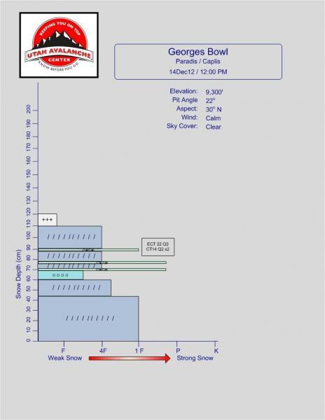
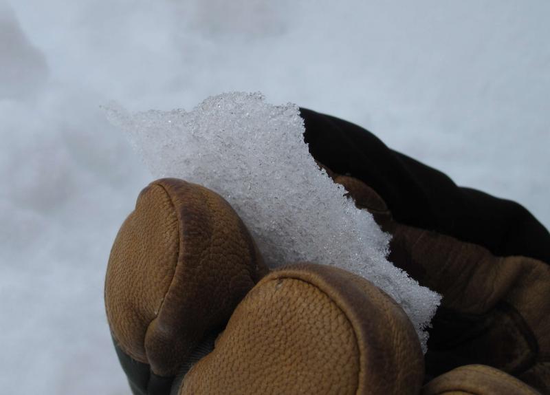
Photo of upper most crust
Coordinates