Get Your Ticket to the 32nd Annual Backcountry Benefit on September 11th! Support Forecasting, Awareness, and Education

Observation Date
11/19/2012
Observer Name
Greg Gagne
Region
Salt Lake
Location Name or Route
Catherine's Pass Area
Weather
Sky
Broken
Wind Direction
West
Wind Speed
Light
Weather Comments
Cloud deck seemed to hang over Alta side of upper LCC whilst everywhere else seemed to clear. -3 C
Snow Characteristics
New Snow Depth
10"
New Snow Density
High
Snow Surface Conditions
Dense Loose
Wind Crust
Snow Characteristics Comments
Super-dense and graupel-laden. Fun for traveling and riding and just the kind of snow we need in the early season. Some wind affected snow along ridges from SW-NW winds from Sunday into Monday morning.
Red Flags
Red Flags
Poor Snowpack Structure
Red Flags Comments
Was finding 10-15 cms of faceted snow and depth hoar near the ground on northerly aspects. This snow was damp and undergoing rounding, but still reactive to stability tests (further described.)
Avalanche Problem #1
Problem
New Snow
Trend
Decreasing Danger
Problem #1 Comments
Full propagation extended column failing on facets/depth hoar near the ground. ECTP22 @ Q1.
Snow Profile
Aspect
North
Elevation
10,200'
Slope Angle
36°
Comments
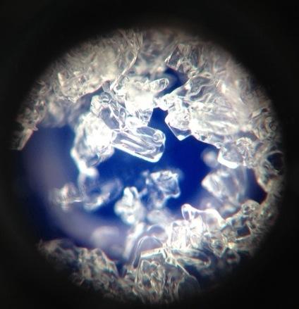
Overall was not finding the new snow sensitive and could only produce moderate to hard shears at the storm snow interface (now buried about 25 cms - 10"). Some wind loading on lee aspects from SW-NW winds yesterday and overnight, yet wind slabs were shallow and not sensitive at all to ski cuts. Full propagation on ECT with the slab popping out at Q1/SC shows faceted snow near the ground remains a player. Grains appear to be rounding, but you can still clearly see the angular edges. Grain sizes about 1 mm. Photo/profile shows no temperature gradient, so this will continue to heal, but it appears to be taking its time. Not entirely sure what to make of this as stability tests show buried persistent weak layer, yet haven't heard of recent activity on this layer.