


Forecast for the Uintas Area Mountains

Issued by Craig Gordon on
Wednesday morning, January 1, 2025
Wednesday morning, January 1, 2025
Please take a minute and think about the consequences of your terrain choices today... the snowpack remains super sketchy and the setup is nothing to mess with. A miscalculation is the difference between having an epic New Year's day with fresh pow or we get greedy, underestimate the hazard and don't come home to our families-
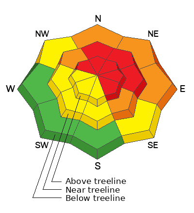
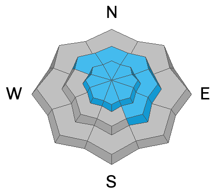
Recent winds coupled with dense, heavy snow deliver a one-two punch and the avy danger is HIGH. We might not be seeing natural avalanches today, but HUMAN triggered avalanches are VERY LIKELY, particularly on steep, leeward slopes at and above treeline, and especially in the wind zone in terrain with an easterly component to its aspect. Today’s avalanches will break deeper and wider than you might expect and they'll pack a powerful, season ending, machine vaporizing punch.
Mid and upper elevation terrain facing the south half of the compass offers MODERATE avy danger. While a bit more predictable, human triggered avalanches are still POSSIBLE on steep wind drifted slopes.
Generally LOW avalanche danger exists in terrain facing the south half of the compass at lower elevations near the trailheads. In fact, I've been finding fantastic riding in big, wide open meadows and low-angle slopes not surrounded by or connected to nearby steep terrain or overhead hazard... done, done, and done.
Low
Moderate
Considerable
High
Extreme
Learn how to read the forecast here
 Weather and Snow
Nowcast- High clouds are just beginning to drift into the Uinta zone as southwesterly winds bump into the mid 20's to greet the New Year. Temperatures register in the single digits at most locations, yet still scratch their way out of negative territory near the ridges. No new snow overnight, but the Christmas storm was the gift that kept giving, delivering a couple feet of dense, heavy snow, and 2"-3" of water weight or what we call SWE (Snow Water Equivilant). No matter how you do the math, the snow is becoming mostly supportable whilst riding and turning conditions have vastly improved.
Forecast- Look for mostly cloudy skies and a flurry or two developing during the day as a weak storm slides to the north. High temperatures climb into the upper 20's with southwest winds bumping into the 30's as the day progresses. Overnight lows dip into the mid 20's.
Futurecast- A nice shot of snow materializes tonight and lingers through Thursday. I'm thinking we see 5"-8" stack up by mid day before skies begin to clear. A brief break Friday morning followed by yet another, albeit weaker storm slated to round out the work week.
 Recent Avalanches
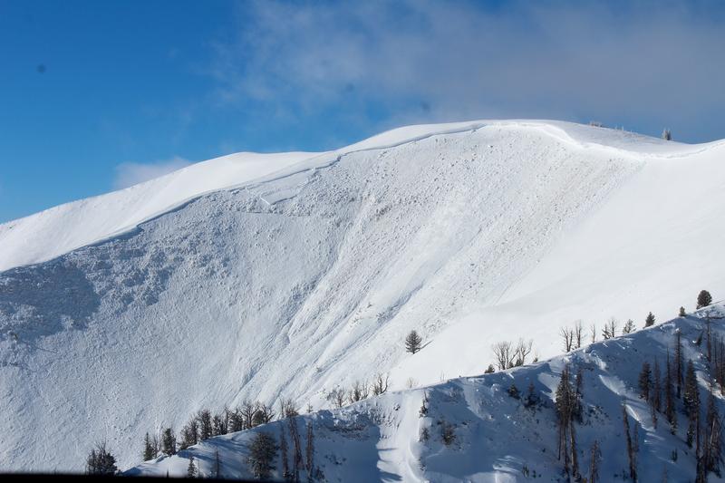
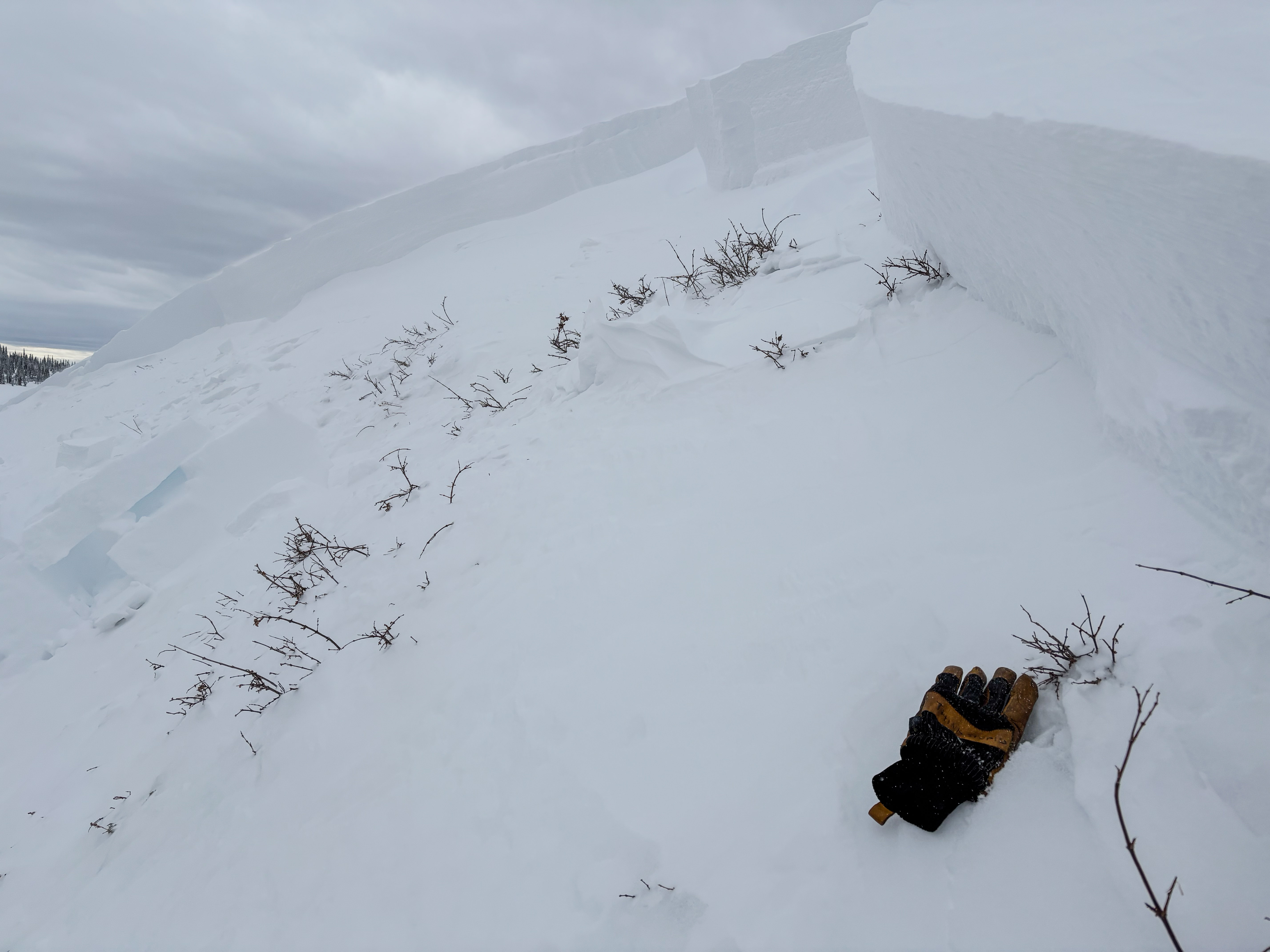
Above is an image of an absolute monster on the Weber Canyon/Chalk Creek divide that avalanched early Tuesday morning. Breaking 8-10 feet deep and 1500 feet plus feet wide, this is the type of avalanche dragon we're dealing with today.
From Strawberry Rez to Evanston, an aerial view of the postage stamp revealed the affirmation that 2024 got the party started early and went out with a bang. Of note, a widespread avy cycle in the likely suspects, but also unsuspecting slopes like treed terrain and mid slope pockets, particularly on the south half of the range which tipped the scales with 3" SWE.
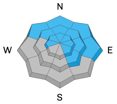
No shortage of natural avalanche activity, human triggered avalanches, and even a close call. Yup, avalanche activity has been widespread across the range. Nearly all avalanches are failing on old, faceted snow buried up to 4’-6' deep on slopes facing the north half of the compass. Recent avalanches are breaking hundreds of feet wide and annihilating the entire season's snowpack.
Huge thanks to everyone for helping us out by providing very timely observations, insight, and honesty. Remember... your intel helps save lives, so please keep the info rollin' in! All those obs and trip reports along with info from neighboring Utah forecast zones are found here.

Avalanche Problem #1
Persistent Weak Layer
Type
Location
Likelihood
Size
Description
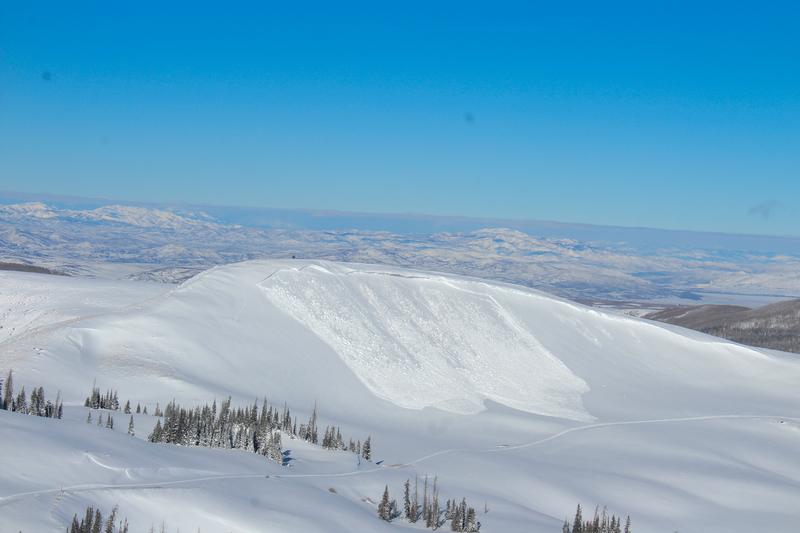
Yet another natural slide on Tower Mountain occurring sometime Tuesday morning.
While the sensitivity of today's avalanches might've calmed down slightly, the consequence remain severe. At all elevations on the north half of the compass, we’re hearing about and seeing avalanches running fast and far, breaking into faceted snow near the ground. Here's where it gets tricky... terrain that already avalanched during last weekends storm doesn't present that fresh, recent avalanche look or showroom smell. In fact, most of the evidence of recent avalanche activity is now blown back in and camouflaged by fresh snow. Problem is... any slope that didn't avalanche, waits for us to roll along and knock the legs out from underneath or even from an adjacent slope. If you're on the receiving end, today's avalanches are gonna meaty, pack a devastating punch and will instantly ruin your day, as well as those waiting for you at home.
Avalanche Problem #2
Wind Drifted Snow
Type
Location
Likelihood
Size
Description
Perhaps a bit more stubborn than in the past few days, both fresh and older wind drifts are gonna be hard to identify because they're covered over by a blanket of fresh snow. So, what I'm doing is simply avoiding fat rounded slopes, especially if they sound hollow like a drum. And remember, fresh wind drifts aren't always a manageable avalanche problem. Once triggered, today's drifts can get out of hand quickly and break into deeper, faceted layers in the snowpack.
Additional Information
The Mill Hollow snow site is up and running! Current data is found here.
General Announcements
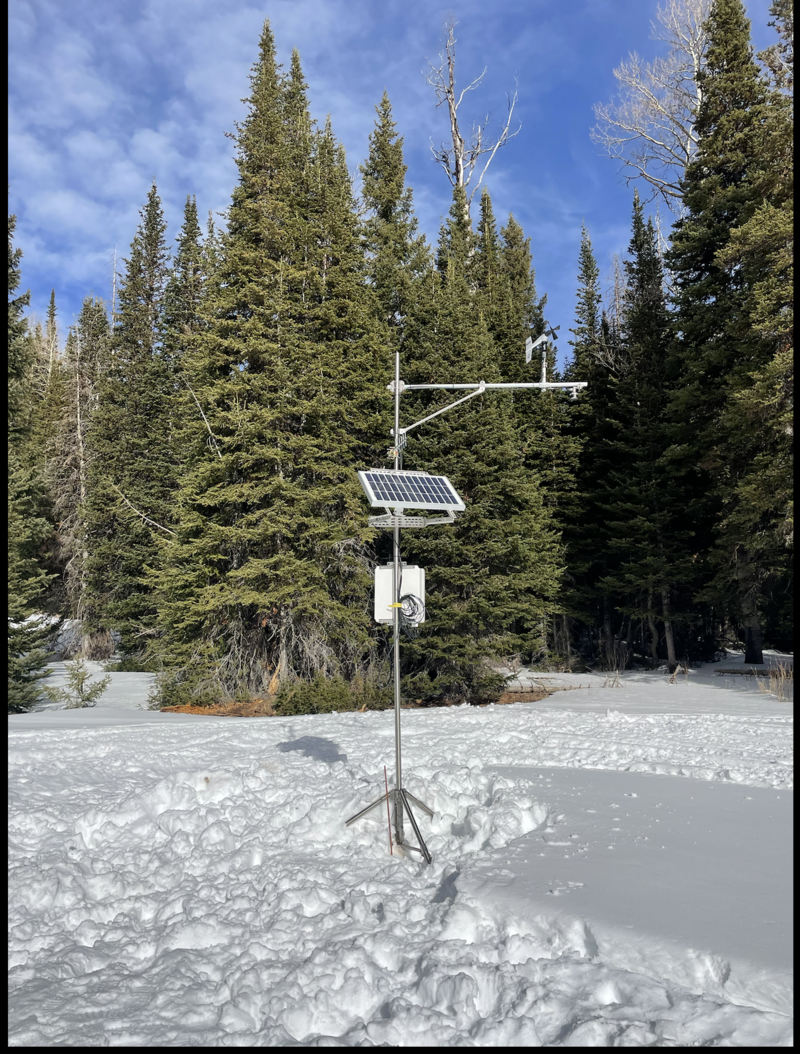
The Uinta weather station network was upgraded this summer and all that real-time info is found here. Simply click on the "Western Uinta" tab and then the "Weather Stations" tab to find all your weather needs.
We are always looking for snow and avalanche observations or just general riding conditions. So... if you see something, say something. You can reach our team directly by contacting: Craig at [email protected], 801-231-2170, or Andrew at [email protected], or 860-460-8142.
General Information
This forecast is from the U.S.D.A. Forest Service, which is solely responsible for its content. This forecast describes general avalanche conditions and local variations always occur. This forecast was issued on Wednesday, January 1st at 04:00AM and expires 24 hours after it was issued. We will update the forecast by 0700 AM tomorrow. But, in the meantime reach out to us with questions, or if you see anything in your travels.