Forecast for the Moab Area Mountains

Eric Trenbeath
Issued by Eric Trenbeath on
Sunday morning, April 13, 2025
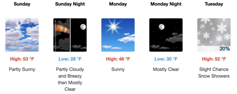
With very warm daytime temperatures and no overnight refreeze the avalanche danger will quickly rise to MODERATE for both loose wet, and wet slab avalanches on all aspects and elevations with the exception of very high northerlies. Sun exposed slopes will become dangerous first starting with E, then S, then W aspects. As the day heats up, north facing slopes near treeline and below will also have the potential to avalanche. The window will be very short this morning. Get in and out early before the snow becomes wet and sloppy.
Low
Moderate
Considerable
High
Extreme
Learn how to read the forecast here
Special Announcements
Today will be our last scheduled avalanche forecast.
Geyser Pass Road: The road is melted out to the dirt down low but becomes increasingly wet and sloppy up high. 4x4 recommended.
Grooming Conditions: Grooming is done for the season.
Weather and Snow
6 A.M. Snow and Weather Data
Weather
General Conditions
Very warm, cloudy, and breezy conditions have not been conducive for corn snow conditions this weekend. With no overnight refreeze, the snow surface will be punchy at best first thing in the morning and it will quickly become wet and sloppy as the day heats up. It's a predictable situation. If you do chose to travel in the mountains today, get in and out early. It looks like we will get a freeze tonight with a better chance for supportable corn conditions on Monday. Cold, dry snow can still be found on the highest north facing slopes.
Northerly aspects hold plenty of snow, while the southerlies are melting out quickly. Ryan Huels photo.
Snowpack and Weather Data
Gold Basin SNOTEL site (10,000')
SNOTEL site near Geyser Pass Winter Trailhead (9600')
Wind Station on Pre-Laurel Peak (11,400')
NWS forecast for the La Sal Mountains.
Recent Avalanches
Ad
Avalanche Problem #1
Wet Snow
Type
Location
Likelihood
Size
Description
As the day heats up, the likelihood for wet avalanches will rise on sun exposed slopes. This includes both loose wet, and possibly even wet slab avalanches. The danger follows the sun with east aspects getting wet first, followed by south and then west. The danger is most pronounced on solar aspects, but with near record temperatures, low and mid elevation northerly aspects will also heat up and shed snow. Pay close attention to the snow surface today. Signs of instability include rollerballs, pinwheels, and sloppy wet snow. Stay off of and out from under steep slopes when these signs are present.
Additional Information
Sign up for text alerts to get the most up to date information about changing conditions, road plowing, special avalanche announcements.
Follow us on Instagram @utavy_moab
General Announcements
This forecast is from the U.S.D.A. Forest Service, which is solely responsible for its content. This forecast describes general avalanche conditions and local variations always occur.