icon-add
Observation
Menu
×
Menu
Forecasts
Logan
Ogden
Salt Lake
Provo
Uintas
Skyline
Moab
Abajos
Weather
Archives
How to read the forecast
Observations & Avalanches
Submit Observation
Observations Explorer
All Observations
Avalanches
Fatalities
Weather
Place Names Map
Archives
Education
Avalanche Class List
UAC Class List
Online Classes
Resources and Tutorials
Avalanche Awareness
Develop Skills
Events
Store
About
Contact
Who we are
Core Values
Staff
Board of Directors
Past Forecasters
Sponsors
Annual Reports
Sign In
Blog
Donate / Join
Search
Forecasts
Logan
Ogden
Salt Lake
Provo
Uintas
Skyline
Moab
Abajos
Weather
Archives
How to read the forecast
Observations & Avalanches
Submit Observation
Observations Explorer
All Observations
Avalanches
Fatalities
Weather
Place Names Map
Archives
Education
Avalanche Class List
UAC Class List
Online Classes
Resources and Tutorials
Avalanche Awareness
Develop Skills
Events
Store
About
Contact
Who we are
Core Values
Staff
Board of Directors
Past Forecasters
Sponsors
Annual Reports
Sign In
Blog
Menu
Search
icon-add
Observation
Donate / Join
Submit Observation
Observations Explorer
All Observations
Avalanches
Fatalities
Weather
Place Names Map
Archives
Submit Observation
Observations Explorer
All Observations
Avalanches
Fatalities
Weather
Place Names Map
Archives
Observation: Logan
Observation Date
3/14/2025
Observer Name
Richie Schumacher
Region
Logan
Location Name or Route
Mt Naomi Wilderness
Weather
Sky
Broken
Wind Direction
Northwest
Wind Speed
Light
Weather Comments
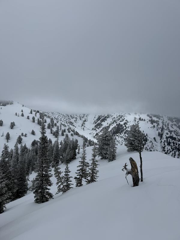
Started feeling cold in the high 20s with a light breeze and broken skies at the TH. Had a brief period of clearing in the AM, followed by increasing clouds into the afternoon. Cloud ceilings were around 8500' throughout the day, obscuring peaks.
Snow Characteristics
New Snow Depth
4"
New Snow Density
Low
Snow Surface Conditions
Powder
Snow Characteristics Comments
the new snow was light and likely preceded by rain at lower elevation and was a mix of stellars and graupel at mid and upper elevations.
At lower elevations, 1-2" of low density new snow sat on top of a
wet base of snow. New snow at these elevations was damp by mid day.
at elevations above about 7500', 2-4" of low density new snow with pockets of 4-6" of medium density wind blown, but non-consolidated, snow was sitting atop the old snow which was still dry on polar aspects.
Red Flags
Red Flags Comments
Other than some small grain facets forming below the crust this and the last storm fell on that had a Q2 RP hand shear (no other signs of instability on this layer throughout the day), no red flags were noted. The new snow and the snow from last storm sit right side up on top of a dust layer and a crust (with thin layer of small grain facets below) which lay on a 1F base (pictured)
Snow Profile
Aspect
North
Elevation
8,300'
Comments
Photo 1: general zone/ cloud ceiling
Today's Observed Danger Rating
Low
Tomorrows Estimated Danger Rating
Moderate