March Kicks Off Our Spring Campaign- Donate Now to Support Forecasting

Forecast for the Skyline Area Mountains

Brett Kobernik
Issued by Brett Kobernik on
Monday morning, March 10, 2025
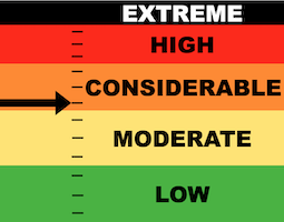
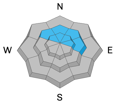
The avalanche danger is decreasing but is still CONSIDERABLE on upper elevation very steep slopes that face northwest through east.
As the snowpack settles and stabilizes, it is becoming less likely but still possible to trigger an avalanche that breaks deep into older sugary faceted snow. (low probability, high consequence)
Low
Moderate
Considerable
High
Extreme
Learn how to read the forecast here
Special Announcements
Do you get value from these daily avalanche forecasts? The Utah Avalanche Center is very reliant on donations to help fund the operation. Please consider a donation to the Spring fundraiser campaign. Even small amounts help!
MORE DETAILS HERE
Weather and Snow
Current Conditions: Temperatures were in the upper 30s to low 40s on Sunday. Wind from the southwest has remained light. There's just a slight bump in speeds along the highest peaks. Riding conditions remain quite good on upper elevation northerly facing terrain. Other areas are getting hit by the sun and warm temperatures making them damp. You'll find lots of frozen crusts this morning that will soften during daytime heating.
Mountain Weather: Today looks like a repeat of Sunday with sunny skies and warm temperatures. Temperatures may get slightly warmer with highs into the 40s. Wind will remain light from the southwest. We may see a few clouds later this afternoon. More clouds roll through Tuesday and Wednesday then a pretty decent looking period of storms moves in late Thursday lasting through the weekend.
Ad
Avalanche Problem #1
Persistent Weak Layer
Type
Location
Likelihood
Size
Description
As time goes on and the snowpack gets deeper, it will become more stable. The older deeper layers of weak snow will continue to slowly gain strength. The snow above those weak layers will create a stronger "bridge" making it harder to break into the older weak layers.
The big question is, when are the weak layers stable enough to trust? In my opinion, we are not there yet and I continue to avoid really steep terrain.
The most likely places to trigger an avalanche that breaks into facets is in areas that have a more shallow snowpack. If you are easily punching through into sugar with your boots or machine, you are most likely in a shallower, weaker location. Collapsing or "whoomping" of the snowpack underneath you is a major red flag.
Avalanche Problem #2
Wet Snow
Type
Location
Likelihood
Size
Description
Be aware that we may see some wet avalanche activity on sunny slopes today as the warm temperatures make the cold snow become damp. In general, this doesn't usually pose a great threat to people on the Skyline. However, if you get into the wrong place at the wrong time, there is certainly some danger. Simply avoid steep terrain when the snow becomes really wet and sloppy.
General Announcements
This forecast is from the U.S.D.A. Forest Service, which is solely responsible for its content. This forecast describes general avalanche conditions and local variations always occur.