Forecast for the Moab Area Mountains

Eric Trenbeath
Issued by Eric Trenbeath on
Thursday morning, February 27, 2025
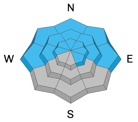
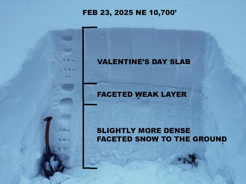
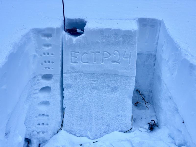
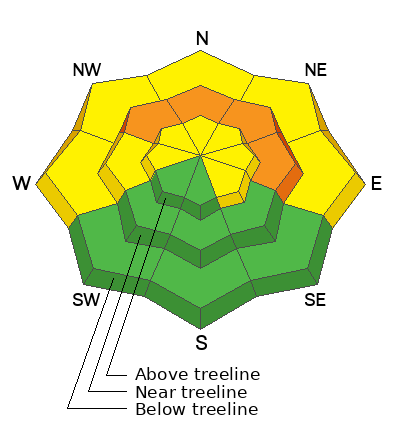
A CONSIDERABLE avalanche danger exists on steep, northerly aspects near treeline. In these areas, human-triggered avalanches 2 feet deep or more, failing on a persistent weak layer of faceted snow are likely.
The danger is MODERATE on all other slopes facing W-N-E, and on upper elevation, SE aspects, and human-triggered avalanches failing on this weak layer remain possible, to highly possible, especially on steep northerly aspects.
Low
Moderate
Considerable
High
Extreme
Learn how to read the forecast here
Special Announcements
Check out the latest UAC podcast with forecaster Brett "Kowboy" Kobernick where he discusses faceted persistent weak layers and how "nobody is immune from getting killed in an avalanche."
We are excited to announce the launch of our new mobile application available on both Android and IOS. Get all the information you need to plan your backcountry adventure and keep the information at the tip of your fingers while you are out. Install the Android version here and the IOS version here.
Geyser Pass Road: The road is plowed to the winter trailhead. It remains slick and snow packed. AWD and good tires recommended.
Grooming Conditions: I'm planning to head up and groom today.
Weather and Snow
6 A.M. Snow and Weather Data
24 Hour Snow: 0" 72 Hour Snow: 0" Season Total Snow: 82" Depth at Gold Basin: 37"
Winds on Pre-Laurel Peak: N/A Temp: 23° F Percent of Normal (SWE): 72%
Weather
Pre Laurel Peak wind station and the Gold Basin storm stake will be down through the weekend as we install upgrades including a web cam to the site.
Under clear skies mountain temperatures are in the low 20's. Regional winds are light from the southeast. High temperatures will climb up into the mid 30's at 10,000' today and mostly light southeast winds will shift to the northwest. We'll see increasingly warm temperatures over the next couple of days with a chance for snow developing Sunday night as a weak storm tracks by to the south. A more active pattern looks to be picking up next week.
General Conditions
It's been nearly two weeks since the Valentine's Day storm and by general accounting, the danger should have decreased by now. The problem is that we have a thick, cohesive slab on top of a very weak snowpack structure. It's frankly one of the worst snowpack structures I've ever seen and that's saying a lot here in the La Sals. Outward signs of instability like cracking and collapsing have diminished, and you may not observe any major red flags, but slopes that face NW-N-E are hanging in balance just waiting for a trigger, Deep hard slab avalanches remain possible to likely on these slopes. These are potentially deadly, season-ending avalanches. The only safe strategy is to keep your slope angles to less than 30 degrees or head to solar aspects.
Snowpack and Weather Data
Gold Basin SNOTEL site (10,000')
SNOTEL site near Geyser Pass Winter Trailhead (9600')
Wind Station on Pre-Laurel Peak (11,400')
NWS forecast for the La Sal Mountains.
Recent Avalanches
See the avalanche database here.
Our closest neighbors over in the San Juans continue to experience frequent, human triggered avalanches and they even had a large, natural avalanche on February 24. Check out their database here.
Ad
Avalanche Problem #1
Persistent Weak Layer
Type
Location
Likelihood
Size
Description
The Valentine's Day storm has built a dense, cohesive slab on top of our weak, underlying snowpack. Outward signs of instability such as collapsing and whumphing are isolated at this point, but stability tests remain active. Dave's tests on Monday show that avalanches can fail on multiple different weak layers and can easily step down to the weak facets below, creating a very deep and dangerous avalanche. Avalanches that step down could take out the entire season's snowpack. The bottom line is that human-triggered avalanches up to 2 feet deep or more, failing on this weak layer remain highly possible. The danger is most acute on northerly and easterly aspects near treeline, but slopes below the treeline harbor the same poor snowpack structure. Travel advice is to avoid any slope steeper than 30 degrees where this problem exists.
As you wrap around to the west, the problem still exists and it's a fine line between shady and sunny. Many westerly aspects still present as northerly if there are trees to provide shade. West facing slopes should be considered guilty until proven innocent, and a slope by slope analysis is required.
This photo is from my last field day on Sunday. The structure hasn't changed. An extended column test produced results of ECTP 24. Dave experienced similar results on Monday.
Additional Information
In the video below, I describe one of the worst snowpack structures I've ever seen. I am avoiding avalanche terrain on any slope that holds this poor structure and this will likely be my mindset until spring. Some seasons you just can't touch steep terrain, and this may be one of those years.
Check out the latest edition of the UAC podcast with Moab forecaster Dave Garcia where he talks about the challenges of forecasting for our remote and isolated range with limited information.
Sign up for text alerts to get the most up to date information about changing conditions, road plowing, special avalanche announcements.
Follow us on Instagram @utavy_moab
General Announcements
This forecast is from the U.S.D.A. Forest Service, which is solely responsible for its content. This forecast describes general avalanche conditions and local variations always occur.