Observation: Butler Basin

Observation Date
2/26/2025
Observer Name
Collett, Manship
Region
Salt Lake » Big Cottonwood Canyon » Butler Fork » Butler Basin
Location Name or Route
Butler Basin
Weather
Sky
Clear
Wind Speed
Light
Weather Comments
Cold temps this morning and warming by mid morning. Overall calm wind with light gusts out of the North.
Snow Characteristics
Snow Surface Conditions
Powder
Melt-Freeze Crust
Damp
Snow Characteristics Comments
Stout melt freeze crust on all aspects around 8000' this morning. Solars began to soften around 10:00 AM and provided some surprisinly good corn skiing. Above 8500' cold snow still exists in sheltered northerly terrain.
Red Flags
Red Flags
Poor Snowpack Structure
Red Flags Comments
We found very poor structure on slope that had avalanched a couple weeks back. See avalanche problems below for details.
Avalanche Problem #1
Problem
Persistent Weak Layer
Trend
Same
Problem #1 Comments
Digging on a slope that had avalached back on 2/13 we found a very poor snowpack structure. The overall HS was between 100-120 cm, and was comprised of a cohesive F to 1F slab atop well developed 4-6 mm depth hoar that showed no signs of rounding. We did not get any propagtion on the depth hoar in ECTs the structure was alarmily poor. This shallow and weak structure on slopes that have avalanches speaks to the spatial variability of our snowpack here in the Wasatch. While some areas are sitting at nearly 3 m of snow with relatively good structure you can still find very weak snow and poor structure on slopes with thin snowpacks. See video below for more explanation.
Avalanche Problem #2
Problem
Wet Snow
Trend
Same
Problem #2 Comments
Colder temps and a light breeze from the North seemed to keep the snow surface from warming rapidly this morning. No wet activity observed by our exit at 12:30. As noted in other obs there is quite a bit of evidence of wet activity from the past couple days and we saw some old but impressively large roller balls on steep N facing slopes around below 8000'.
Snow Profile
Aspect
North
Elevation
9,400'
Slope Angle
36°
Comments
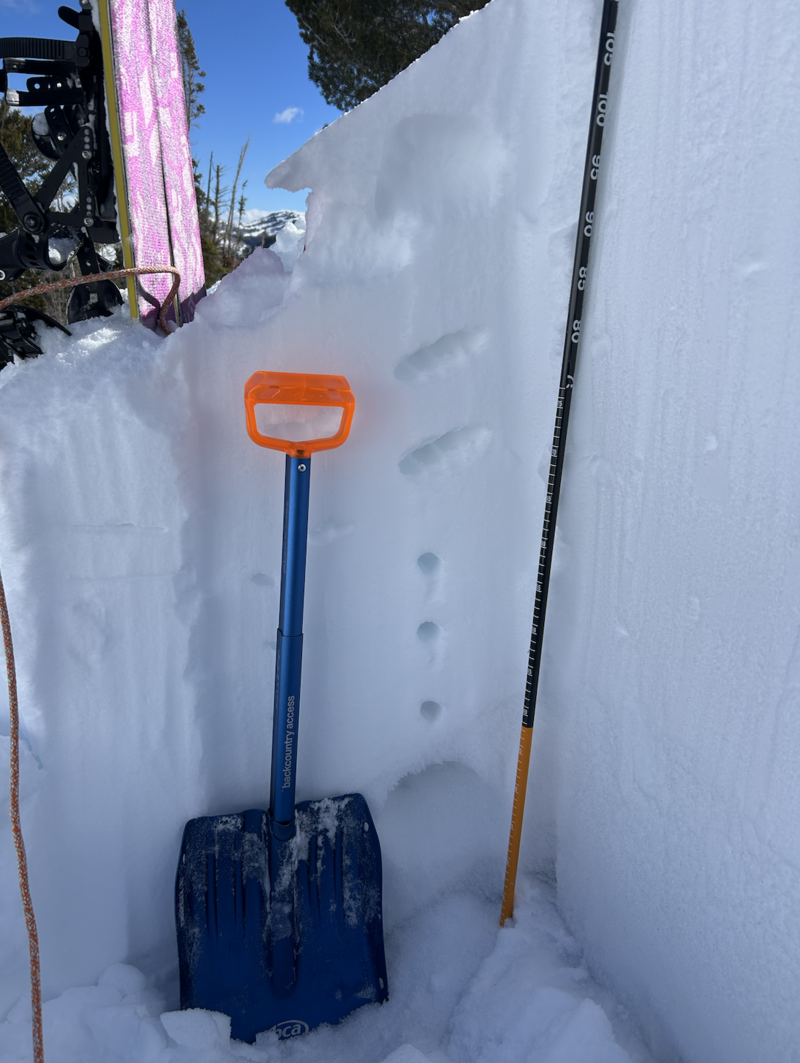
We traveled into the Butler Basin with the objective of finding weak snow and a thin snowpack on a slope that recently avalanched. We choose to investigate a slope that was skier triggered on 2/13 to see how much it had filled in and what the weak layer was looking like. The slope had filled in pretty well but if you knew what you were looking for you could still see the crown, flanks, and debris pushed against trees. No surprise we found a shallow snowpack and weak snow just where you'd expect to find it. Implications are that we have a lot of spatial variablily in our snowpack right now and knowing slope specific history is critical for avoiding the areas with the most dangerous snowpacks. While it's almost the end of February the snowpack on slopes that have avalanched look more akin to December or January snowpacks.
Video
Today's Observed Danger Rating
Moderate
Tomorrows Estimated Danger Rating
Moderate
Coordinates
Snow Pilot URL