Forecast for the Ogden Area Mountains

Dave Kelly
Issued by Dave Kelly on
Tuesday morning, February 25, 2025
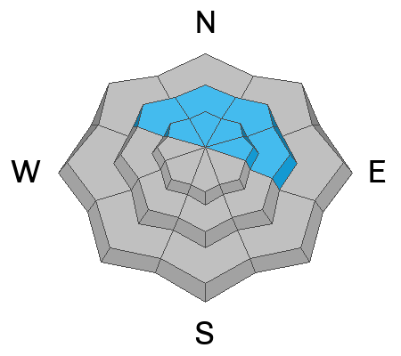
The avalanche danger is MODERATE at all aspects and elevations. Evaluate snow and terrain carefully; identify and avoid features of concern such as wind-drifting on top of buried facets and wet snow at mid and low elevations.
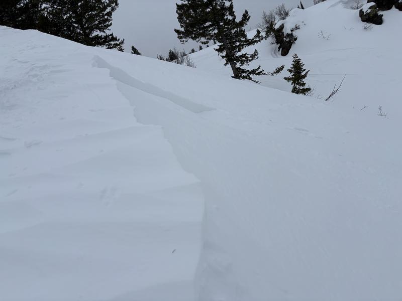
When all else fails choosing to travel on or underneath terrain less than 30 ° in steepness will find you the softest turns and safest routes.
Low
Moderate
Considerable
High
Extreme
Learn how to read the forecast here
Weather and Snow
Under clear skies, trailhead temperatures are in the 40's °F and the highest peaks are in the high 20's °F. Lower elevation zones have been above freezing for over twenty-four-hours. Winds at the lower elevations are blowing from the north in the teen's gusting to the 30's MPH and at the highest weather stations from the west in the 30's gusting to the 50's MPH. There was no new snow last night and with these warm temperatures we are seeing settlement within the snowpack throughout the forecast region.
Today, look for partly cloudy skies with temperatures ranging from 42-46°F. Winds will blow from the northwest at the lower ridgelines 25 gusting to 35 MPH and from the west at the highest peaks 30 gusting to 50 MPH with gusts to 60MPH. There is a cold front moving through today and a chance of light precipitation. Winds will increase with the frontal passage and should shift to the northwest.
Recent Avalanches
Yesterday, we had reports of small wet loose avalanches and of a soft-not supportable wet snow surface below 7,000'. Our recent observations page has all the updated details.
Ad
Avalanche Problem #1
Persistent Weak Layer
Type
Location
Likelihood
Size
Description
A variety pack of buried persistent weak layers are variable and make for a complex problem. Thinner, rockier spots, and areas that avalanched earlier in the season are more likely to be places where you could trigger an avalanche failing on a buried layer of facets. If you hear any signs of collapsing at any elevation or aspect then find a lower angle slope to travel on or underneath.
We are not done with this buried persistent weak layer yet and as much as the mindset in late February typically turns to open-season, it's not that type of season. Give this snowpack some time to settle into its spring coat.
Avalanche Problem #2
Wet Snow
Type
Location
Likelihood
Size
Description
Many weather stations have had no refreeze in almost two days. The snowpack in the mid and lower elevation terrain out of the wind zone may be saturated and the chance of triggering a gouging wet snow avalanche will increase with warming temperatures. Areas with long run out zones where avalanches could start as dry snow avalanches and turn into wet snow avalanches may overrun the snow line and people not traveling in starting zones could be susceptible to avalanches.
Avoid being underneath avalanche terrain on mid and lower elevation slopes, particularly during the heat of the day.
Photo (JB) of wet loose avalanches on an east facing slope at 7,000'.
Avalanche Problem #3
Wind Drifted Snow
Type
Location
Likelihood
Size
Description
With increased wind speeds overnight and throughout the day today, there will be drifting snow in mid and higher elevation terrain. Look for and avoid slopes with overhanging cornices and smooth rounded deposits of snow. If you see signs such as cracking and collapsing within the wind-drifted snow then you may be able to trigger avalanches in steep terrain (greater than 30°). Any slope involving wind-drifted snow on a buried layer of facets will be deeper and more likely to bury a human.
Photo (Schumacher) of a wind-drifted snow avalanche on Cutler Ridge.
General Announcements
This information does not apply to developed ski areas or highways where avalanche control is normally done. This forecast is from the U.S.D.A. Forest Service, which is solely responsible for its content. This forecast describes general avalanche conditions and local variations always occur.