Forecast for the Logan Area Mountains

Toby Weed
Issued by Toby Weed on
Tuesday morning, February 25, 2025
Avalanche conditions are elevated, human-triggered avalanches are possible, and MODERATE danger exists in most terrain. There also may be areas with CONSIDERABLE danger in sunny terrain and on drifted upper-elevation slopes, where natural slab avalanches are possible, and people could probably trigger dangerous avalanches failing on a persistent weak layer buried 3 to 4 feet deep.
Evaluate the snow and terrain carefully, make conservative choices, and continue to practice safe travel protocols.
Low
Moderate
Considerable
High
Extreme
Learn how to read the forecast here
Special Announcements
Help the University of Utah understand risk behavior in the backcountry by participating in a 15-minute survey. The U will compensate up to $30 for your time! Please note: responses will not be confidential but will be handled ethically under IRB guidelines.
Weather and Snow
It stayed warm overnight, and the saturated snow in sunny terrain did not refreeze solidly. Mountain temperatures should cool down during the day and drop below freezing tonight, which will help with the wet avalanche problems. Winds are howling out of the west this morning on Logan Peak, with 30 mph average wind speeds and a gust of 61 mph in the last half hour. Yesterday's heat destroyed last week's nice powder, even up high in the Central Bear River Range. But temperatures remained cooler in the northern part of the Logan Zone, and some drifting is likely occurring.
Early yesterday afternoon, I spotted a large natural on the south face of Beirdneau Peak. I'm not sure of the timing or if it was actually a wet slab, but it could have been triggered by heat shock mid-morning yesterday. It looks to have failed on a persistent weak layer on the early February dusty crust. This natural avalanche on a south-facing slope and Saturday's human-triggered Boss Canyon avalanche on an east-northeast-facing slope both failed on a buried, persistent weak layer, highlighting the complexity of the problem.

-The Tony Grove Snotel at 8400 feet reports 34° F, with 94 inches of total snow. It's 29° F, at the Card Canyon weather station at 8800 feet, with 65 inches of total snow.
At 9700 feet at CSI's Logan Peak, winds are blowing 34 mph from the west with gusts of over 60 mph this morning, and it's 25° F. On Paris Peak at 9500 feet, it's 21° F, with winds blowing 25 to 30 mph from the southwest, with overnight gusts of 46 mph.

Expect mostly sunny skies, with mountain temperatures dropping to around 26° F at 8500 feet this evening. Winds from the west-northwest will blow 15 to 20 mph with gusts in the 30s. Tonight will be partly cloudy with low temperatures around 16° F and winds from the west-northwest 7 to 16 mph. Tomorrow will be sunny with 5 to 8 mph winds from the west and a high temperature around 30° F at 8500 feet. A strong high pressure moves into the zone Wednesday with warm temperatures and sunshine expected into the weekend.

For more information, visit the UAC weather page here: Weather - Utah Avalanche Center
For Logan-specific weather, go here: Logan Mountain Weather - Utah Avalanche Center
Recent Avalanches
  • Yesterday afternoon, I could see a large natural avalanche on the south face of Beirdneau Peak. Report is HERE. I'm not sure if this was a wet slab avalanche, but it was likely caused by solar warming and perhaps heat shock. (see photo below)
  • A snowmobiler triggered an avalanche near the warming hut in Boss Canyon on Saturday that unfortunately injured a rider who was below the slope. The large hard slab avalanche failed on a buried persistent weak layer and was 4 to 5 feet deep and about 500 feet wide. Read the preliminary report HERE.
Read about all avalanches and observations HERE.
Ad
Avalanche Problem #1
Persistent Weak Layer
Type
Location
Likelihood
Size
Description
While the likelihood of triggering an avalanche on a buried PWL is decreasing, the consequences of doing so are not.
Large and dangerous avalanches failing on one of several buried persistent weak layers remain possible, especially in areas with shallower snow and poor snow structure. People could trigger cornice falls and avalanches of previously and/or recently drifted snow that may then step down into deeper layers on many upper and mid-elevation slopes, and the danger is most acute on upper-elevation slopes facing northwest through southeast.
  • Audible collapses (whumpfs) and shooting cracks are sure signs of instability, but these may not be present when avalanches occur.
  • Avalanches failing on a buried persistent weak layer might be triggered remotely (from a distance) or from below steep slopes.
Avalanche Problem #2
Wind Drifted Snow
Type
Location
Likelihood
Size
Description
Winds picked up overnight, and they drifted heavy new snow into lee slope avalanche starting zones. Avoid areas of freshly wind-drifted snow that may sound or feel hollow; wind-drifted snow is generally much denser than surrounding snow. Fresh wind slabs will be found in and around terrain features like cliff bands, sub-ridges, and gullies. Watch for shooting cracks, and be aware that any avalanche may step down into deeper weak layers.
Avalanche Problem #3
Wet Snow
Type
Location
Likelihood
Size
Description
Expect sunny skies, and while cooling is anticipated, mountain temperatures will be warm again today, elevating the danger of wet avalanches. Natural wet avalanches are possible in areas where people may not expect them, like where you might walk the dog, throw a fly, or build a snowman. Roller balls and pinwheels are sure signs of instability.
*Logan River fishers should avoid being under steep slopes with saturated snow.
Additional Information
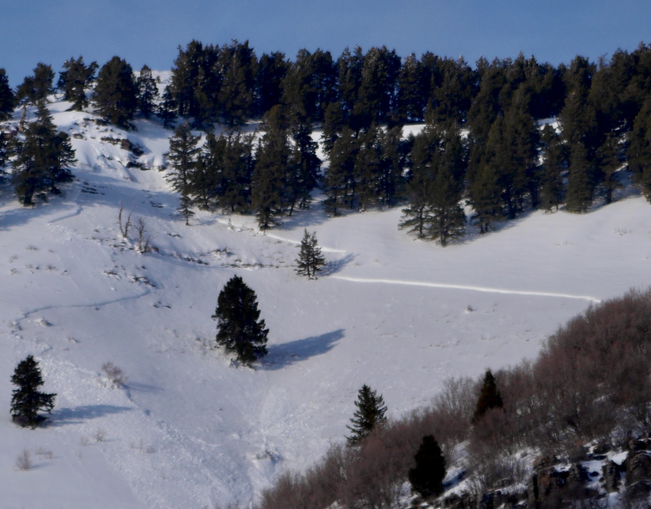
A large natural avalanche could be seen on the south face of Beirdneau Peak yesterday afternoon.
Here is the video we made about the 2/22 Boss Canyon Accident. Big thanks to all for sharing your photos and videos and for telling the terrifying story. We can all learn from this incident, and the lessons learned may well save lives.
General Announcements
-National Forest Winter Recreation Travel Maps show where it's open to ride: UWCNF Logan, Ogden LRD Tony Grove, Franklin Basin CTNF Montpelier
-For all questions on forecasts, education, Know Before You Go, events, online purchases, or fundraising, call 801-365-5522.
-Remember the information you provide could save lives, especially if you see or trigger an avalanche. To report an avalanche or submit an observation from the backcountry, go HERE.
-Receive forecast region-specific text message alerts to receive messages about changing avalanche conditions, watches, and warnings. Sign up and update your preferences HERE.

This forecast is from the U.S.D.A. Forest Service, which is solely responsible for its content. This forecast describes general avalanche conditions, and local variations always occur.