Forecast for the Logan Area Mountains

Toby Weed
Issued by Toby Weed on
Monday morning, February 24, 2025
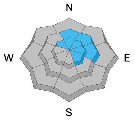
Avalanche conditions are elevated, human-triggered avalanches are possible, and MODERATE danger exists in most terrain. There are also areas with CONSIDERABLE danger on drifted upper-elevation slopes facing northwest through southeast, where avalanches of wind-drifted snow and cornice falls are likely today. You could trigger a dangerous avalanche failing on a persistent weak layer buried 3 - 4 feet deep. Rain on the snow at lower elevations elevated the danger of wet avalanches.
  • Evaluate the snow and terrain carefully, make conservative choices, and continue to practice safe travel protocols.
  • Avoid wind-drifted slopes and cornices in upper-elevation terrain and stay out from under steep slopes with rain-saturated snow down low.
Low
Moderate
Considerable
High
Extreme
Learn how to read the forecast here
Special Announcements
Help the University of Utah understand risk behavior in the backcountry by participating in a 15-minute survey. The U will compensate up to $30 for your time! Please note: responses will not be confidential but will be handled ethically under IRB guidelines.
Weather and Snow
We found nice powder conditions in the Franklin Basin area yesterday, but a bit of sleet or rime began to adversely affect the snow surface in open areas in the afternoon. It stayed pretty warm overnight, and the rain/snow line was high, but a few inches of heavy snow accumulated in upper elevation terrain. Yesterday's strong winds from the west and southwest drifted snow and created shallow wind slabs in exposed upper and mid-elevation terrain. The winds have moderated a bit today, but they continue to blow from the west and drift snow.
We examined the large and terrifying avalanche in Boss Canyon, where a rider at the bottom of the slope was caught and injured. It turns out that most avalanche accidents occur after a storm, even as the snow is becoming more stable, and when the danger is rated Considerable or Moderate. People start to push their luck as the danger diminishes, and when powder conditions are good and the sun comes out, they are willing to take more risks. Even if you are not expecting avalanches, please follow safe travel protocols in avalanche terrain (slopes steeper than 30°); expose only one person at a time while the rest of your party (or other spectators) watches from a safe area. Do not park, cool your sled, or stop for lunch in avalanche runouts, especially if someone is riding above.
If you want to ride safely in steep terrain, you need to do some homework. There are still buried persistent weak layers, and you need to be sure they are not present or reactive where you want to ride in steep terrain. If you don't want the hassle of digging test pits, stick to slopes less than 30 degrees, and you'll have a great, safe day.

-The Tony Grove Snotel at 8400 feet reports 3 inches of heavy snow overnight. It's 33° F, with 97 inches of total snow. It's 30° F, at the Card Canyon weather station at 8800 feet, with 69 inches of total snow.
At 9700 feet at CSI's Logan Peak, winds are blowing 20 to 30 mph from the west with overnight gusts of 43 mph, and it's 28° F. On Paris Peak at 9500 feet, it's 27° F, with winds blowing 15 to 20 mph from the southwest, with overnight gusts of 33 mph.

Snowfall will taper off this morning and partly sunny skies are expected. Expect a high of 40° F at 8,500 feet. Winds will be moderate, blowing from the west-southwest 10 to 15 mph. Tonight will be mostly cloudy with low temperatures around 26° F and winds from the southwest 10 to 15 mph. Tomorrow will be partly sunny and breezy with a chance for a little snowfall in the morning. A strong high pressure moves into the zone Wednesday with warm temperatures and sunshine.

For more information, visit the UAC weather page here: Weather - Utah Avalanche Center
For Logan-specific weather, go here: Logan Mountain Weather - Utah Avalanche Center
Recent Avalanches
A snowmobiler triggered an avalanche near the warming hut in Boss Canyon on Saturday that unfortunately injured a rider who was below the slope. The large hard slab avalanche failed on a buried persistent weak layer and was 4 to 5 feet deep and about 500 feet wide. It was triggered as the rider climbed a previously untouched steep section and topped out. We are thankful no one was killed, and the group was willing to share their story. Read the preliminary report HERE.
In addition to Boss Canyon, there were several close calls and accidents over the weekend in the Western Uintas and the Wasatch Mountains above Salt Lake City and Provo.
Read about all avalanches and observations HERE.
Ad
Avalanche Problem #1
Persistent Weak Layer
Type
Location
Likelihood
Size
Description
While the likelihood of triggering an avalanche on a buried PWL is decreasing, the consequences of doing so are not.
Large and dangerous avalanches failing on one of several buried persistent weak layers remain possible, especially in areas with shallower snow and poor snow structure. People could trigger cornice falls and avalanches of previously and/or recently drifted snow that may then step down into deeper layers on many upper and mid-elevation slopes, and the danger is most acute on upper-elevation slopes facing northwest through southeast.
  • Audible collapses (whumpfs) and shooting cracks are sure signs of instability, but these may not be present when avalanches occur.
  • Avalanches failing on a buried persistent weak layer might be triggered remotely (from a distance) or from below steep slopes.
Avalanche Problem #2
Wind Drifted Snow
Type
Location
Likelihood
Size
Description
Winds picked up yesterday, and they drifted new snow into lee slope avalanche starting zones. Avoid areas of freshly wind-drifted snow that may sound or feel hollow - wind-drifted snow is generally much denser than surrounding snow. Fresh windslabs will be found in and around terrain features like cliff bands, subridges, and gullies. Watch for shooting cracks, and be aware that any avalanche may step down into deeper weak layers.
Avalanche Problem #3
Wet Snow
Type
Location
Likelihood
Size
Description
Rain saturated the snow at low elevations overnight, and mountain temperatures will be pretty warm today, elevating the danger of wet avalanches. Natural wet avalanches are possible in areas where people may not expect them, like where you might walk the dog, throw a fly, or build a snowman. Roller balls and pinwheels are sure signs of instability.
*Logan River fishers should avoid being under steep slopes with saturated snow.
Additional Information
Here is the video we made about the 2/22 Boss Canyon Accident. Big thanks to all for sharing your photos and videos and for telling the terrifying story. We can all learn from this incident, and the lessons learned may well save lives.
General Announcements
-National Forest Winter Recreation Travel Maps show where it's open to ride: UWCNF Logan, Ogden LRD Tony Grove, Franklin Basin CTNF Montpelier
-For all questions on forecasts, education, Know Before You Go, events, online purchases, or fundraising, call 801-365-5522.
-Remember the information you provide could save lives, especially if you see or trigger an avalanche. To report an avalanche or submit an observation from the backcountry, go HERE.
-Receive forecast region-specific text message alerts to receive messages about changing avalanche conditions, watches, and warnings. Sign up and update your preferences HERE.

This forecast is from the U.S.D.A. Forest Service, which is solely responsible for its content. This forecast describes general avalanche conditions, and local variations always occur.