Observation Date
2/15/2025
Observer Name
Brackelsberg
Region
Salt Lake
Location Name or Route
PC Ridgeline
Weather
Sky
Broken
Precipitation
Light Snowfall
Wind Direction
Northwest
Wind Speed
Moderate
Snow Characteristics
New Snow Depth
8"
New Snow Density
Low
Snow Surface Conditions
Powder
Snow Characteristics Comments
7-8" of new snow overnight. You could feel the upside-down snow from the Thursday storm under the new snow.
Red Flags
Red Flags
Recent Avalanches
Heavy Snowfall
Wind Loading
Collapsing
Poor Snowpack Structure
Red Flags Comments
A day of red flags. They were everywhere from the recent snow, the strong winds blowing snow, the facets in our snowpit, 2 avalanches observed, and a collapse on a south aspect at 9,350'.
Avalanche Problem #1
Problem
Wind Drifted Snow
Trend
Same
Problem #1 Comments
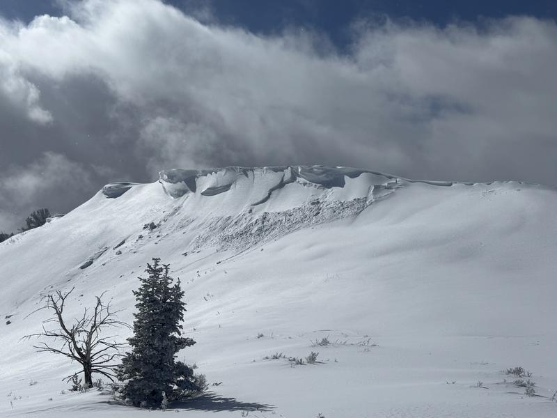
We saw 2 large cornice breaks. One on a north and one on a south aspect.
Avalanche Problem #2
Problem
Persistent Weak Layer
Trend
Same
Problem #2 Comments
I selected PWL as the second problem, but it could easily be new snow. I didn't select new snow since the snow seemed to be bonded well to the old snow. The facet layer under the crust (see snow profile) was very pronounced, but I the area we dug, we did not get propagation in our extended column test (ECT). This layer is getting close to a meter deep which will hopefully help reduce the risk of this layer.
Snow Profile
Aspect
North
Elevation
8,900'
Slope Angle
23°
Comments
As elsewhere in the Wasatch, the cornices on the ridgelines are getting huge (see photo).
We traveled on both north and south aspects today. We dug our snowpit on a north aspect. We had lots of red flags, but conditions seemed more stable than we were expecting.
Today's Observed Danger Rating
Considerable
Tomorrows Estimated Danger Rating
Considerable
Coordinates