Join us at our 2nd Annual Blizzard Ball

Forecast for the Skyline Area Mountains

Brett Kobernik
Issued by Brett Kobernik on
Tuesday morning, January 21, 2025
.
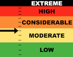
Today's avalanche danger on the Manti Skyline is MODERATE.
In areas with recent deposits of wind drifted snow, human triggered avalanches are possible.
Avoid steep slopes that have fresh drifts, pillows, cornices and slabs of wind drifted snow.
The most likely spots to trigger something is on the north and east sides of the compass.
Low
Moderate
Considerable
High
Extreme
Learn how to read the forecast here
Weather and Snow
Current Conditions: Temperatures bottomed out below zero last night but have started rebounding already. Wind has remained moderate in speed from the west northwest for days. This has produced a moonscape of wind damaged surface snow in many locations.
Mountain Weather: We'll have clear skies and much warmer temperatures today. Highs should actually get into the 20s. Moderate speed west northwest wind is going to continue and it looks like it's going to get pretty strong this afternoon. Clear skies continue on Wednesday with slightly cooler temperatures.
Recent Avalanches
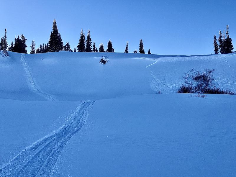
There's been widespread shallow wind slabs that have released naturally over the last several days. There have also been a few snowmobile triggered pockets. Most of these are around 8 inches deep but some pockets are breaking up to a couple of feet. Of note in the photo below, we collapsed and cracked out the slope to the left of the avalanche when we climbed it. It failed in weak faceted snow near the ground. It just wasn't steep enough to avalanche.
Photo: Natural avalanche in Beck's Creek. THIS IS THE TYPE OF TERRAIN WHERE YOU ARE LIKELY TO TRIGGER SOMETHING TODAY.
Ad
Avalanche Problem #1
Wind Drifted Snow
Type
Location
Likelihood
Size
Description
Areas with deposits of wind drifted snow are the biggest threat out there today. Many of these are shallow and don't have serious consequences if you trigger one. Some will be deeper and on larger slopes that have serious consequences.
Simply avoid steep slopes where the wind has been depositing snow. The most likely places to trigger something are on steep slopes that face northeast, east and southeast but watch for fresh pillows and drifts around terrain features on all aspects. INCREASED WIND SPEEDS THIS AFTERNOON WILL INCREASE THE AVALANCHE DANGER.
.
Avalanche Problem #2
Persistent Weak Layer
Type
Location
Likelihood
Size
Description
Sorry folks, you're going to hear me talk about the old Persistent Weak Layers for some time to come still. During fieldwork on Monday while riding sleds through Seely and Becks Creek (east of Ephraim Canyon), my partner and I experienced collapsing and shooting cracks in a number of locations. The common theme was a shallow, sugary underlying snowpack (3 feet or less) with a recently formed wind drift on top of it. Any steep slope with this setup is suspect. The only thing you can do is avoid steep slopes where this situation is present.
General Announcements
This forecast is from the U.S.D.A. Forest Service, which is solely responsible for its content. This forecast describes general avalanche conditions and local variations always occur.