Join us at our 2nd Annual Blizzard Ball

Forecast for the Logan Area Mountains

Paige Pagnucco
Issued by Paige Pagnucco on
Sunday morning, January 19, 2025
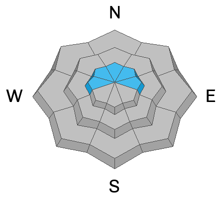
There is MODERATE avalanche danger, and human-triggered avalanches are possible in upper-elevation terrain. The problem is most pronounced along ridgelines and around lee terrain features, and here, you could trigger sensitive slabs of wind-drifted new snow. Isolated deep slab avalanches, breaking 2 to 4 feet deep on a persistent weak layer, are unlikely, yet the consequences could be severe. Otherwise, and elsewhere, the danger is LOW.
  • Evaluate snow and terrain carefully and continue to practice safe travel protocols by only exposing one person at a time in avalanche terrain.
  • You'll find very good powder riding conditions in shaded, sheltered terrain.
  • Prepare for very cold temperatures for the next few days and adjust your travel plan accordingly.
Low
Moderate
Considerable
High
Extreme
Learn how to read the forecast here
Weather and Snow
It was great yesterday to see so many people out enjoying the fresh snow. We got reports of 4-6" of low-density snow across the range, though it looks like south of Logan Peak was favored and had a surprise 8-12". The new snow is the lightest of the season and made for fun riding conditions. We observed shallow, loose dry avalanches in very steep terrain and below cliffs involving just the top few inches of the new snow. Winds picked up overnight, and with light snow available for transport, the biggest concern for today is wind-drifted snow. These wind slabs should be isolated to prominent ridgelines and lee terrain features and could be about 1-2 feet deep. The likelihood of triggering a persistent deep hard slab avalanche is very low, but we are still suspicious of slopes holding poor snowpack structure, mainly on the north half of the compass.
*Be prepared for very cold temperatures today. Plan accordingly and have extra layers, warm drinks, and a fire starter, in case of an emergency. Frostbite and hypothermia are a real concern if you get too cold or stop moving for too long.

-The 8400' Tony Grove Snotel reports 7° F, with 60 inches of total snow (99% of normal SWE for the date).
-Winds are blowing from the west this morning at 9700' CSI weather station on Logan Peak at 25 mph with gusts of 35 mph, and it's -1° F, with a windchill of -27° F.
At our Card Canyon station, it's 2° F at 8800 feet, and there is 46 inches of snow total.
-On Paris Peak at 9500 feet in Bloomington Canyon, it is -2° F and the winds are blowing from the west-southwest at 18 to 25 mph. The windchill is -25° F.
Today will be another cold day in the mountains, with a forecast high of 10° F and light to moderate winds from the west, switching to the northwest later in the day. Skies will be mostly cloudy, with a chance of snow, though little accumulation is expected. Cold temperatures are the big story for at least the next few days before a gradual warmup begins toward the end of the week. (Sorry, there are no pictures from yesterday. It was too cold!)

For more information, visit the UAC weather page here: Weather - Utah Avalanche Center
For Logan-specific weather, go here: Logan Mountain Weather - Utah Avalanche Center
Recent Avalanches
  • Read about all avalanches and observations in the Logan Zone HERE.
  • Remember, the information you share about avalanches you see or trigger could save lives.
Ad
Avalanche Problem #1
Wind Drifted Snow
Type
Location
Likelihood
Size
Description
It is possible to trigger small avalanches of wind-drifted snow today. Drifting overnight built shallow wind slabs of new snow in exposed upper-elevation terrain. These could be sensitive as they were formed on weak surface snow.
  • Avalanches of wind-drifted snow are most likely on the lee side of major ridges, especially on slopes capped by cornices.
  • Fresh wind slabs may be found in and around terrain features like cliff bands, sub-ridges, gullies, and scoops.
  • Watch for cracking as a sign of instability.
Avalanche Problem #2
Persistent Weak Layer
Type
Location
Likelihood
Size
Description
Dangerous hard slab avalanches failing on a persistent weak layer buried 2 to 4 feet deep are unlikely but remain possible in isolated or outlying terrain with poor snow structure. Weak faceted snow exists near the ground on almost all northerly-facing slopes at upper elevations. While the snow is becoming more stable, the buried, sugary, persistent weak layer near the ground is still a potential problem. While the new light snow didn't add much weight to this problem, it is still on my radar and I plan to avoid slopes with faceted snow at the bottom of the snowpack.
  • Rocky windswept slopes with thin snow cover are the most suspect.
  • Isolated avalanches might be triggered remotely (from a distance) or from below.
  • No signs of instability may exist when these avalanches occur.
General Announcements
-National Forest Winter Recreation Travel Maps show where it's open to ride: UWCNF Logan, Ogden LRD Tony Grove, Franklin Basin CTNF Montpelier
-For all questions on forecasts, education, Know Before You Go, events, online purchases, or fundraising, call 801-365-5522.
-Remember the information you provide could save lives, especially if you see or trigger an avalanche. To report an avalanche or submit an observation from the backcountry, go HERE.
-Receive forecast region-specific text message alerts to receive messages about changing avalanche conditions, watches, and warnings. Sign up and update your preferences HERE.

This forecast is from the U.S.D.A. Forest Service, which is solely responsible for its content. This forecast describes general avalanche conditions, and local variations always occur.