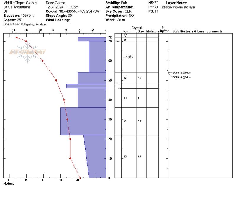
It seems we are past the peak of instability from last week's loading event. Below treeliine, there is a thin slab from the last three inches of snow that fell at 0.4" SWE. This snow was then subjected to very warm temperatures on 12/29. This slab is thin, soft, and crumbles beneath my shovel in stability tests. The weak snow beneath is not overburdened by this load.
As I gained elevation I encountered areas that were previously drifted. Here, the slab is thicker and more cohesive and I had a few collapses in isolated areas. The slabs formed by blowing and drifting penetrated some near treeline terrain, but are not widespread NTL. Slopes NTL should be evaluated on an individual basis before committing to anything steeper than 30 degrees.
It is more likely to trigger an avalanche above treeline, where slab formation is most widespread. While the slabs were formed by previous drifting, any triggered slides will behave like a PWL problem because the slabs are sitting on weak faceted snow that was the old snow surface prior to the storm. This weak layer is easy to identify and is just below the new and drifted snow. The collapsing I experienced today tells me there is still some sensitivity in this layer, but you need to find deeper and denser slabs over this weak layer for it to fail. My stability tests today produced no propagation.

The top of the basal facets at this location have really gained some strength. The layer from 36-22 is 1F hardness and shows signs of rounding (see photo below). The temperature profile also shows favorable conditions for rounding. Last week's loading event does not seem to be enough to affect the basal facets, and my concern right now is for avalanches failing in the weak snow near the top of the pack. Any slide triggered on this layer can entrain enough snow to then step down and cause a failure at the base of the pack.


