Observation Date
12/29/2024
Observer Name
Magerl
Region
Skyline » Huntington Canyon » Electric Lake
Location Name or Route
Electric Lake
Weather
Sky
Overcast
Wind Direction
West
Wind Speed
Calm
Weather Comments
Bright hazy sun at 10 A.M. changing to fully obscured by noon. The sun and unseasonably warm temperatures heavied up the snow, and the clouds turned that into a thin crust. Most of the morning and early afternoon was unpleasantly warm and virtually still. By late afternoon the wind was ripping. The plumes of snow rising up off Horseshoe Mountain were clearly visible with the naked eye from Fairview, 20 miles away.
Snow Characteristics
New Snow Depth
3"
New Snow Density
Medium
Snow Surface Conditions
Dense Loose
Snow Characteristics Comments
On East through NE facing at 8,700 feet to 9,200 feet. The snow started out fairly light, but the sun caused everything to get heavy. The lower elevation snow was quite heavy by 2 P.M. Skinning was an exercise in balance, patience and subtle movements. Every pole plant all day was quite happy to go all the way to the ground. Frequent random break-throughs of skis on the skin track kept you paying attention. With subtle turns, skis never broke through on the descents, and turns were predictable and fun.
Red Flags
Red Flags
Wind Loading
Cracking
Collapsing
Poor Snowpack Structure
Red Flags Comments
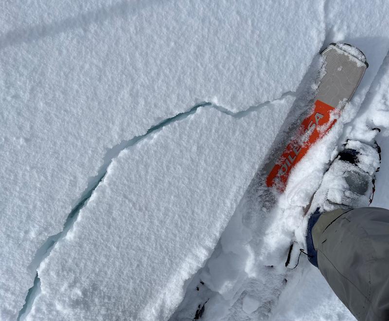
Whumphville out there today. In our first up track, more than a dozen very clear collapses, including two that had me waiting for the snow to run. We read the forecast, and were keeping it conservative, never on anything steeper than 24. Had whumphing on the second lap up, and the third and the fourth. All on the same up track. A clear reminder that just because something has tracks on it, it does not mean it is safe. It might just be waiting for the next trigger. We supplied that repeatedly. Exact same skin track. On the later laps the sounds of the whumphs often came for farther and farther out. Remote triggering on the skin track, fortunately on benign terrain.
Avalanche Problem #1
Problem
Persistent Weak Layer
Problem #1 Comments
Collapsing, poles punching to the ground, boots penetrating to the ground .... That base layer is junk, and will not support the weight of new snow on top. It is just waiting for a trigger, and today it didn't take much.
Avalanche Problem #2
Problem
Wind Drifted Snow
Problem #2 Comments
Sunday afternoon the wind is transporting a lot of snow. East-facing ridgelines in steep terrain will likely be very sensitive Monday morning.
Comments
Snow depth varied from about 65 cm to about 90 cm on northeast facing between 8,700 feet and 9,200 feet. Collapses on the skin track would frequently cause the top 30cm-40cm to try to pull out. A hasty pit at 8,700 feet NE facing showed a crust about 40 cm from the ground with loose unconsolidated below and a 30cm-40cm slab of dense snow above. The slab moved quite easily.
Today's Observed Danger Rating
Considerable
Tomorrows Estimated Danger Rating
Considerable


