Forecast for the Logan Area Mountains

Issued by Toby Weed on
Thursday morning, December 26, 2024
Thursday morning, December 26, 2024
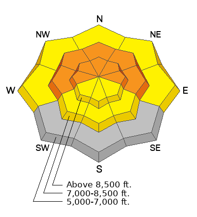
Expect rising avalanche danger in the backcountry today, as heavy snow and drifting by strong winds overload slopes with preexisting weak snow. The avalanche danger is CONSIDERABLE on northerly facing slopes at upper and mid-elevations. People could trigger dangerous slab avalanches failing on a persistent weak layer buried one to three feet deep. Avalanches could be triggered remotely (from a distance) or from below! The danger will likely rise to HIGH in drifted terrain tonight, with natural avalanches becoming more likely.
Careful snowpack evaluation, cautious route-finding, and conservative decision-making are required for safe backcountry travel. People should continue to avoid drifted upper-elevation slopes steeper than 30°
Low
Moderate
Considerable
High
Extreme
Learn how to read the forecast here
Avalanche Watch
- Heavy snowfall and drifting by strong winds will elevate backcountry avalanche danger over the next several days. Very dangerous conditions and HIGH avalanche danger are expected to develop in many areas.
- The Avalanche Watch is for rising avalanche danger, with very dangerous conditions continuing through the weekend and into next week.
- The Avalanche Watch is for the mountains of Northern and Central Utah as well as Southeastern Idaho, including: the Wasatch Range, the Bear River Range, the Western Uinta Mountains, and the Wasatch Plateau
Impacts: Very dangerous avalanche conditions are expected to develop on many slopes. Avalanches can be triggered on slopes steeper than 30 degrees. They may also be triggered remotely (from a distance) or from below.
What to do: Avoid traveling on or underneath steep terrain at mid and upper elevations in the backcountry. Carry and know how to use avalanche rescue equipment. Find safer riding conditions on slopes less than 30 degrees with no overhead hazard.
 Special Announcements
Now is a great time to dial in your safety gear including putting fresh new batteries in your beacons! Local shops across the state will be handing out free Batteries for Beacons now until February 1, 2025. All you need to do is fill out a quick survey and grab the AAA or AA batteries you need to keep your beacon fresh this season. Find participating shops and more info HERE.
 Weather and Snow
Heavy snowfall and significant drifting by increasing wind from the southwest and west will cause rising avalanche danger in the backcountry today. Pretty good riding conditions can be found in sheltered terrain in smooth meadows and on grassy low-angle slopes. It's easy to hit shallowly buried land mines, and we've had reports of significant damage to sleds caused by riding off-trail.
This week, the avalanche situation is tricky and particularly dangerous in the Bear River Range. A persistent weak layer of sugary faceted snow is widespread in upper-elevation terrain, and most slopes are plagued by very poor snow structure. As heavy snow and drifting overload these slopes the avalanche danger will rise dramatically. Remotely triggered avalanches remain possible, and dangerous avalanches might be triggered from flat terrain below steep slopes. The best way to avoid getting caught is to stay off and well out from under slopes steeper than about 30°.
-The Tony Grove Snotel reports 1 inch of new snow in the last 24 hours. It's 22° F, with 34 inches of total snow at 8400 feet in elevation.
-Winds on Logan Peak increased overnight, now blowing from the south-southwest 30 mph with gusts around 45 mph. It's 15° F at 9700 feet in elevation.
-It's 18° F at 8800 feet at our Card Canyon station, with about a half inch of new snow, and 30 inches of total snow.
-On Paris Peak at 9500 feet in Bloomington Canyon, it is 14° F with south-southwest winds blowing around 10 mph, with gusts in the mid-twenties.
Expect snow today, heavy at times, with 6 to 10 inches of accumulation possible in upper-elevation terrain. High temperatures at 8500 feet will peak near 26° F. Intensifying winds from the west-southwest will blow 10 to 18 mph, with much higher gusts (30 to 40 mph). Snowfall will continue tonight, with 5 to 9 additional inches of accumulation possible. Expect more snow tomorrow, with winds from the west increasing again and another 6 inches to a foot of accumulation. Snow will continue to fall, heavily at times, through Saturday night, and we'll be measuring accumulations as feet rather than inches. Plan to avoid being in avalanche terrain this weekend because the avalanche danger is likely to skyrocket through the roof.
For more information, visit the UAC weather page here: Weather - Utah Avalanche Center
For Logan-specific weather, go here: Logan Mountain Weather - Utah Avalanche Center
 Recent Avalanches
-On Christmas Eve, two local riders (brothers) had a very close call with a large avalanche in Steep Hollow in Franklin Basin. The avalanche was perhaps 2 feet deep and 500 feet wide. It occurred on a northeast-facing slope at around 9000 feet in elevation. The preliminary accident report is HERE
-Rain-on-snow caused numerous natural wet avalanches Monday afternoon at lower elevations, gouging shallow snow to the ground, into the Logan River., and in Beaver Canyon across from the Beav's backside. A few new slides were also observed on Christmas Eve in Logan Canyon.
-You can read all recent local observations HERE.
Avalanche Problem #1
Persistent Weak Layer
Type
Location

Likelihood
Size
Description
Very weak, sugary, faceted snow exists on almost all northerly-facing slopes at upper and mid-elevations. On slopes steeper than 30°, people could trigger dangerous slab avalanches one to three feet deep, failing on the widespread persistent weak layer. Avalanches remain likely on drifted upper-elevation slopes, and are possible even in more sheltered terrain. Low elevation and many southerly facing slopes are mostly bare of snow or have only very shallow coverage.
- Recent avalanches, shooting cracks, and collapsing (whumpfs) are signs of unstable snow. These are "Red Flags," and you should reevaluate your plans if you encounter them in the backcountry.
- Avalanches today could be triggered remotely (from a distance) or from below.
- A ride in even a small avalanche would be perilous due to shallowly buried rocks, stumps, and downed trees.
- As the storm rapidly overloads slopes with poor snow structure, large natural avalanches will become increasingly likely.
Avalanche Problem #2
Wind Drifted Snow
Type
Location
Likelihood
Size
Description
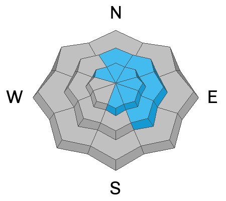
Increasing winds blowing from the southwest were fairly strong overnight, and they are likely to increase further today.
- Avalanches of wind-drifted snow are possible in upper-elevation terrain, and they will become likely as thicker slabs of wind-drifted snow form on the lee side of major ridges.
- Drifting will form wind slabs in exposed terrain and in and around terrain features like cliff bands, sub-ridges, gullies, and scoops.
- In some cases, the new wind slabs may overload slopes hanging in a delicate balance, and larger avalanches stepping down to the widespread buried persistent weak layer are possible.
People should avoid travel in drifted terrain steeper than 30°
Avalanche Problem #3
New Snow
Type
Location
Likelihood
Size
Description
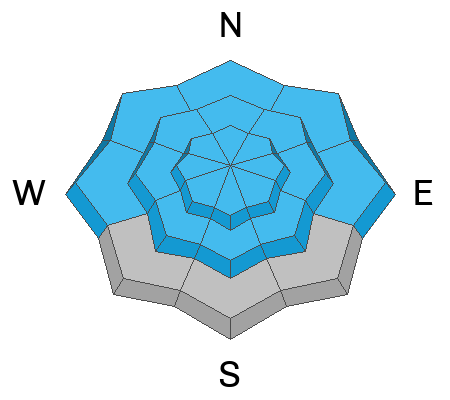
Heavy snowfall and rapid accumulations will cause an increasing danger of loose and soft slab avalanches of new snow at all elevations and on all snow-covered slopes steeper than 30°. Later today, and as the storm continues into the weekend, natural avalanches of storm snow will become possible and they will most likely occur during periods of particularly heavy snowfall.
Additional Information
Trent's video is on point, with similar weak, faceted snow found on hundreds of slopes in the Logan Zone, especially in the southern part.
The snow situation is a bit different in the northern part of the Logan Zone, but loading will cause rising danger. Here is a short video showing an extended column test from Monday's field day in Steep Hollow...
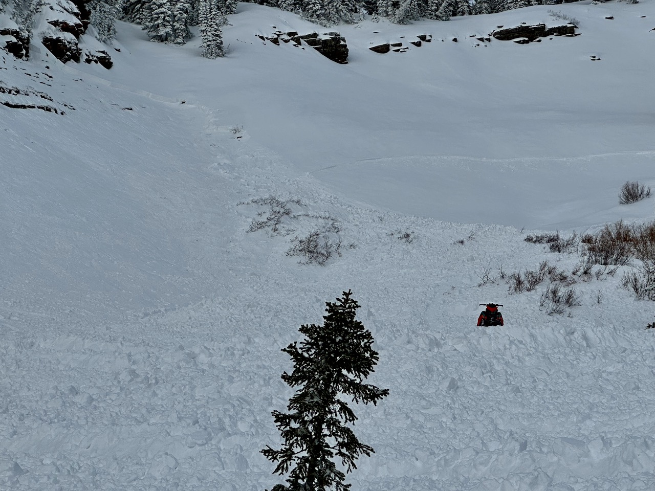 Here's a picture of yesterday's avalanche in Steep Hollow. The rider was side-hilling from left to right when he triggered the avalanche. The tracks escape out of the slide on it's north flank on onto a more southerly-facing slope.
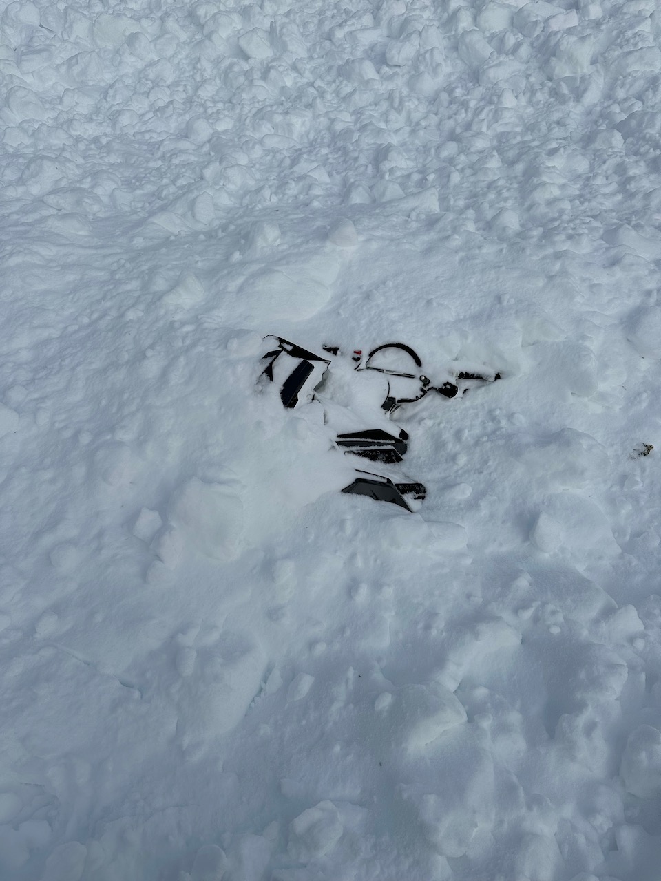
A sled was mostly buried in the avalanche. One of the riders was completely buried but was recovered by his fast-acting brother using a transceiver to get close enough to see a couple fingers sticking out of the snow.
General Announcements
-National Forest Winter Recreation Travel Maps show where it's open to ride: UWCNF Logan, Ogden LRD Tony Grove, Franklin Basin CTNF Montpelier
-Sign up for forecast region-specific text message alerts. You will receive messages about changing avalanche conditions, watches, and warnings...HERE.
-For all questions on forecasts, education, Know Before You Go, events, online purchases, or fundraising, call 801-365-5522.
-Remember that the Tony Grove Road is not maintained for winter driving. Treacherous snow-covered and icy conditions will be encountered.
This forecast is from the U.S.D.A. Forest Service, which is solely responsible for its content. This forecast describes general avalanche conditions, and local variations always occur.


