Join us at our 2nd Annual Blizzard Ball

Forecast for the Logan Area Mountains

Toby Weed
Issued by Toby Weed on
Tuesday morning, December 24, 2024
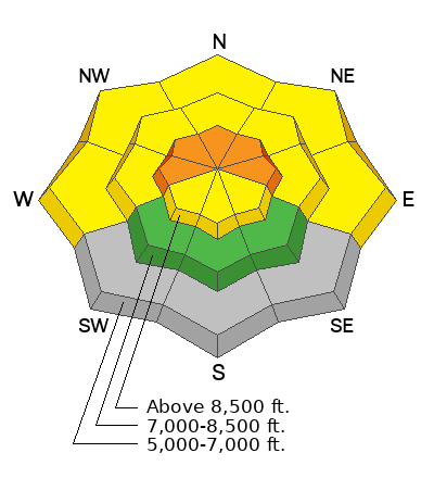
There is CONSIDERABLE avalanche danger on northerly facing slopes at upper elevations. People could trigger dangerous slab avalanches failing on a persistent weak layer buried one to two feet deep. Avalanches could be triggered remotely (from a distance) or from below! Heightened conditions are found on all other upper-elevation slopes, slopes facing W-N-E at mid-elevations, and in lower-elevation terrain where rain saturated the shallow snow.
Careful snowpack evaluation, cautious route-finding, and conservative decision-making are required. People should continue to avoid drifted upper-elevation slopes steeper than 30°.
***Fishermen on the Logan River should stay off and out from under steep slopes with rain-saturated snow.
Low
Moderate
Considerable
High
Extreme
Learn how to read the forecast here
Special Announcements
Now is a great time to dial in your safety gear including putting fresh new batteries in your beacons! Local shops across the state will be handing out free Batteries for Beacons now until February 1, 2025. All you need to do is fill out a quick survey and grab the AAA or AA batteries you need to keep your beacon fresh this season. Find participating shops and more info HERE.
Weather and Snow
In Steep Hollow, we found improved conditions with about 5 inches of moist new snow above about 8000' yesterday. Riding conditions are pretty good in sheltered, north-facing terrain where the underlying snow remains soft and somewhat supportable. The snow, even up high, is still generally quite shallow, and it's really easy to sink through the sugary snow to the shallowly buried, A-arm-bending rocks underneath. Once again, everywhere I checked, I'd sink to the ground when I got off the sled, so I'm reporting boot penetration to the ground. Many south-facing slopes are still bare or too thin for on-snow travel.
The avalanche situation is tricky and particularly dangerous because remotely triggered avalanches remain possible, and avalanches might be triggered from flat terrain below avalanche paths, or an avalanche may not release until you are out in the middle of the slab. The best way to avoid the problem is to stay off and out from under slopes steeper than about 30°.
***Be vigilant, listen, and watch for collapsing, a sure sign of instability.

-The Tony Grove Snotel, at 8400 feet in elevation, reports 5 inches of heavy new snow yesterday. It's 36° F, with 36 inches of total snow.
-Winds on Logan Peak are increasing this morning, blowing from the south at 27 to 30 mph. It's 24° F at 9700 feet in elevation.
-It's 25° F at 8800 feet at our Card Canyon station, with 4 inches of new snow and 31 inches of total snow.
-On Paris Peak at 9500 feet, it is 20° F with south winds blowing 10 to 15 mph.

Expect mostly cloudy skies today, with high temperatures at 8500 feet near 35° F and winds from the south 9 to 11 mph. Some snow is possible in the evening. Snow is likely tonight, with 1 to 2 inches possible. Expect a steady temperature around 29° F. and winds from the south-southwest 6 to 14 mph. A little snow is likely Christmas Morning, with mountain temperatures in the mid twenties and winds from the west-northwest blowing 6 to 10 mph.
A significant change in the weather pattern appears imminent, with a series of Pacific Storms and atmospheric moisture lining up to impact the Logan Zone. Heavy snowfall will begin on Thursday, with 7 to 13 inches possible by Friday morning and 6 to 10 inches on Friday. It looks like stormy weather and copious snowfall will continue through the weekend...
For more information, visit the UAC weather page here: Weather - Utah Avalanche Center
For Logan-specific weather, go here: Logan Mountain Weather - Utah Avalanche Center
Recent Avalanches
-Rain-on-snow caused numerous natural wet avalanches yesterday afternoon at lower elevations (N--W slopes around and <7000'), both WS and WL, gouging shallow snow to the ground, into the Logan River, and in Beaver Canyon across from the Beav's backside.
-A small natural slab avalanche was observed Sunday in the bowl north of Competition Hill in Franklin Basin ID.
-You can read all recent local observations HERE.
Ad
Avalanche Problem #1
Persistent Weak Layer
Type
Location
Likelihood
Size
Description
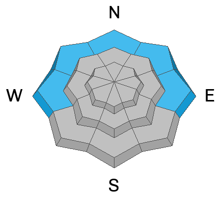
Very weak, sugary, faceted snow exists on almost all northerly-facing slopes at upper and mid-elevations. On slopes steeper than 30°, people could trigger dangerous slab avalanches one to three feet deep, failing on the widespread persistent weak layer. Avalanches remain likely on drifted upper-elevation slopes, and are possible on slopes facing W-N-E at upper and mid-elevations, even in sheltered terrain. Low elevation and many southerly facing slopes were mostly bare of snow or had only shallow coverage before this past week's storms.
  • Recent avalanches, shooting cracks, and collapsing (whumpfs) are signs of unstable snow. These are "Red Flags," and you should reevaluate your plans if you encounter them in the backcountry.
  • Avalanches today could be triggered remotely (from a distance) or from below.
  • A ride in even a small avalanche would be perilous due to shallowly buried rocks, stumps, and downed trees.
Avalanche Problem #2
Wind Drifted Snow
Type
Location
Likelihood
Size
Description
Winds blowing from the south are rapidly increasing this morning, and avalanches of wind-drifted snow are possible in all drifted upper-elevation terrain. Yesterday's moderate winds from the southwest drifted fresh snow into lee slope deposition areas off the major ridges. Drifting today will continue to form shallow wind slabs in exposed terrain and in and around terrain features like cliff bands, sub-ridges, gullies, and scoops. In some cases, the new wind slabs may overload slopes hanging in a delicate balance, and larger avalanches stepping down to the widespread buried persistent weak layer are possible.
People should avoid travel in drifted upper-elevation terrain steeper than 30°
Avalanche Problem #3
Wet Snow
Type
Location
Likelihood
Size
Description
Rain saturated the snow on lower-elevation slopes and caused numerous natural wet avalanches around and below about 7000' in Logan Canyon. Today, more wet avalanches are possible, and people should avoid being on or under slopes with saturated snow steeper than 30°. These avalanches may threaten unknowing fishermen and adventurous Christmas Tree hunters.
Additional Information
Here is a short video showing an extended column test from yesterday's field day...

General Announcements
-National Forest Winter Recreation Travel Maps show where it's open to ride: UWCNF Logan, Ogden LRD Tony Grove, Franklin Basin CTNF Montpelier
-Sign up for forecast region-specific text message alerts. You will receive messages about changing avalanche conditions, watches, and warnings...HERE.
-For all questions on forecasts, education, Know Before You Go, events, online purchases, or fundraising, call 801-365-5522.
-To report an avalanche or submit an observation from the backcountry, go HERE.
-Remember that the Tony Grove Road is not maintained for winter driving. Treacherous snow-covered and icy conditions will be encountered.

This forecast is from the U.S.D.A. Forest Service, which is solely responsible for its content. This forecast describes general avalanche conditions, and local variations always occur.