Forecast for the Logan Area Mountains

Paige Pagnucco
Issued by Paige Pagnucco on
Saturday morning, December 21, 2024
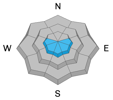
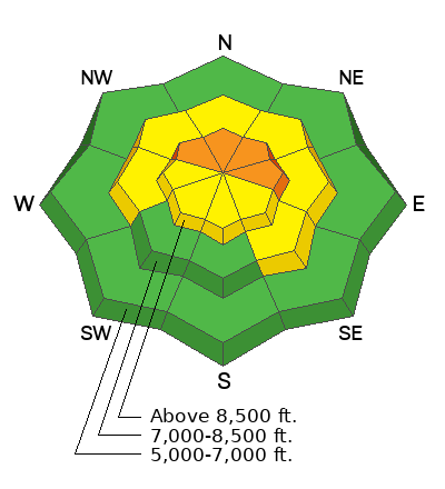
The avalanche danger is CONSIDERABLE on steep, upper-elevation slopes facing northwest through east. People can trigger dangerous slab avalanches one to two feet deep, possibly remotely or from below the slope.
Careful snowpack evaluation, cautious route-finding, and conservative decision-making are required. Avoid previously drifted slopes steeper than 30°.
Low
Moderate
Considerable
High
Extreme
Learn how to read the forecast here
Special Announcements
Now is a great time to dial in your safety gear including putting fresh new batteries in your beacons! Local shops across the state will be handing out free Batteries for Beacons now until February 1, 2025. All you need to do is fill out a quick survey and grab the AAA or AA batteries you need to keep your beacon fresh this season. Find participating shops and more info HERE.
Weather and Snow
Happy Winter Solstice! More hours of daylight equals more time to play in the mountains.
Yesterday, we found signs of both improving stability and continuing instability. We had fewer collapses but still found poor snowpack structure in our pits. Stability tests still showed propagation at the old snow/new snow interface. The slab created by two storms (12/13, 12/17) is about one to two feet thick (possibly three feet in exposed, wind-loaded terrain) and sits atop weak, sugary, faceted snow that fell earlier in November. This setup is tricky because the slab may not release until you are out in the middle of it or find a thin spot. The easiest way to avoid the problem is to avoid slopes steeper than about 30°. Listen and watch for collapsing, a sure sign of instability.
Riding conditions are decent in shaded, sheltered, north-facing terrain where the snow remains soft and somewhat supportable. Outside those areas, the snow is wind-buffed, crusty, or damp. Many south-facing slopes are still too thin for travel.
-The Tony Grove Snotel, at 8400 feet in elevation, reports 36° F, and there is 32 inches of total snow. (69% of normal)
-Winds on Logan Peak are blowing from the south at 24 mph with gusts up to 34 mph, and it's 35° F this morning.
-It's 38° F at Card Canyon, with 28 inches of total snow.
-On Paris Peak at 9500 feet, it is 34° F with southwest winds blowing 11 to 16 mph.

It'll be another warm day in the mountains, with an 8500' high of 40°F, mostly sunny skies, and light winds blowing from the southwest. Tomorrow will be a transition day ahead of a pair of incoming weaker shortwave troughs, with the latter system being the somewhat better organized of the two. The result will be periods of light snow across the higher terrain of northern Utah, with 36-hour totals of two to six inches looking most likely, perhaps more in favored areas. Christmas Eve day looks sunny, and then we return to a more mixed pattern that evening. We may be on track for a white Christmas. Fingers crossed.

For more information, visit the UAC weather page here: Weather - Utah Avalanche Center
For Logan-specific weather, go here: Logan Mountain Weather - Utah Avalanche Center
We still need more snow to travel safely all over the range. Many areas still have very shallow or no snow.
Recent Avalanches
  • Several small natural and remotely triggered avalanches were reported last weekend.
  • On Tuesday, there were some fairly large natural avalanches, including one on the east face of Naomi Pk and a couple on the Sisters in upper Cottonwood.
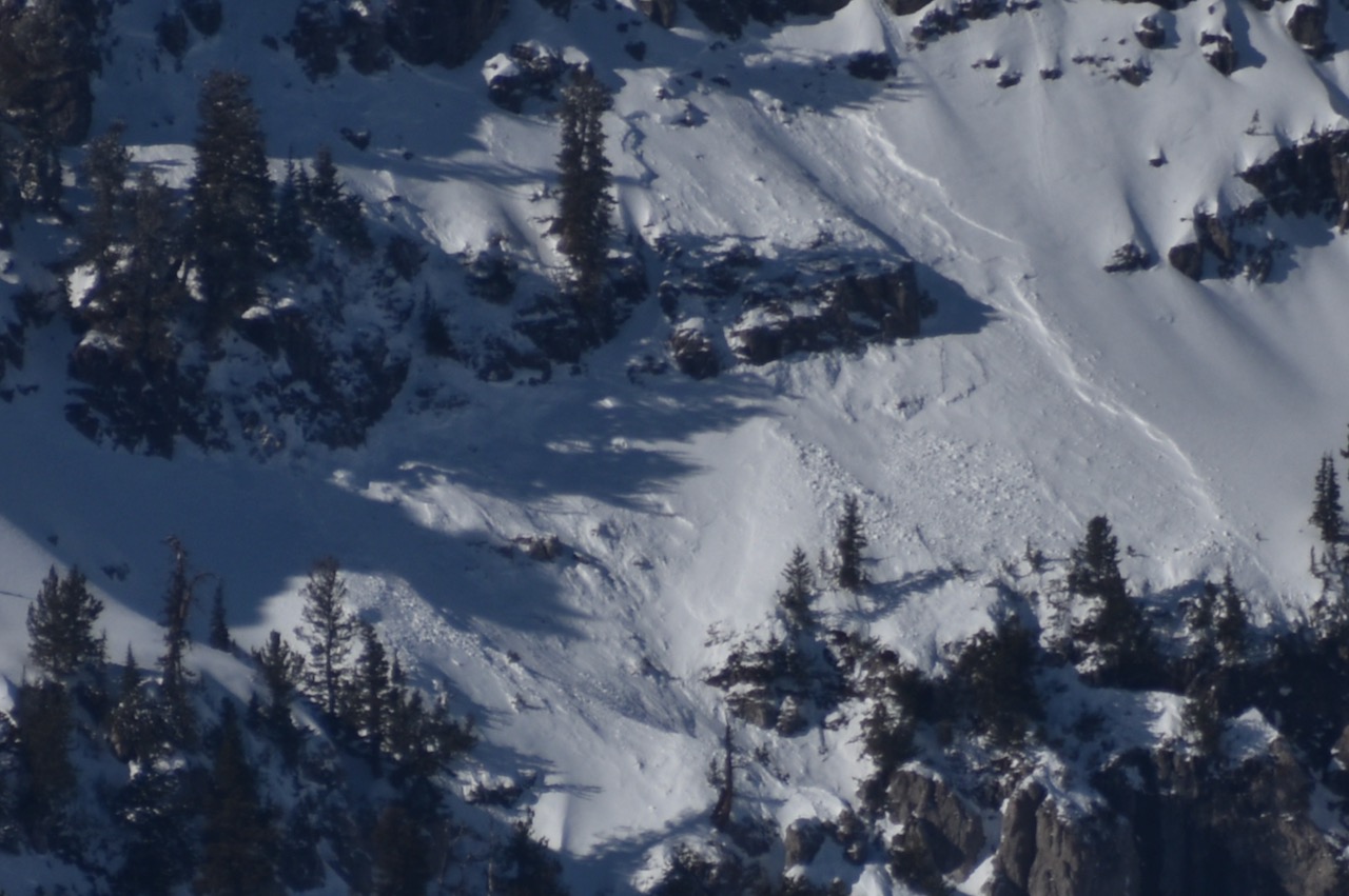
  • Sledders remotely triggered a small avalanche in the cliffs on the southwest corner of Tony Grove Lake. The 2'-deep and 40' wide avalanche probably occurred on Wednesday morning.
You can read all recent local observations HERE.
Ad
Avalanche Problem #1
Persistent Weak Layer
Type
Location
Likelihood
Size
Description
Human-triggered avalanches remain likely at upper elevations. Avalanches of stiff, previously drifted snow could be one to three feet deep, failing on a persistent weak layer of weak, sugary, faceted snow. The Central Bear River Range has picked up around 3.4 inches of SWE in the last week. Avalanches failing on the widespread PWL are possible even in sheltered terrain on slopes steeper than about 30°.
  • Recent avalanches, shooting cracks, and collapsing (whumpfs) are signs of unstable snow. These are "Red Flags," and you should reevaluate your plans if you encounter them in the backcountry.
  • Avalanches today are likely to be triggered remotely (from a distance) or from below.
  • A ride in even a small avalanche is especially dangerous in the early season due to shallowly buried rocks, stumps, and downed trees.
  • Very weak, sugary, faceted snow exists on almost all northerly-facing slopes at upper and mid-elevations. Weak preexisting snow near the ground was also reported on all upper elevation aspects in the northern part of the zone. Low elevation and southerly slopes were mostly bare of snow or had only shallow coverage before this past week's storms.
Avalanche Problem #2
Wet Snow
Type
Location
Likelihood
Size
Description
Small, loose, wet avalanches are possible in sunny terrain, as mountain temperatures have stayed above freezing for the past 48 hours and will remain warm through today. Roller balls, pinwheels, and natural point-release avalanches indicate potential for wet avalanche activity, and if observed, you should move to more shady terrain.
Additional Information
We triggered dozens of whumpfs following the summer trail towards Naomi Peak. Poor snow structure is now widespread in the Logan Zone, with a slab sitting atop very weak, faceted snow. Creating collapses is both fun and unnerving.

A natural avalanche on the east face of Naomi Peak, most likely occurred on Tuesday, 12-17-24.

General Announcements
-National Forest Winter Recreation Travel Maps show where it's open to ride: UWCNF Logan, Ogden LRD Tony Grove, Franklin Basin CTNF Montpelier
-Sign up for forecast region-specific text message alerts. You will receive messages about changing avalanche conditions, watches, and warnings...HERE.
-For all questions on forecasts, education, Know Before You Go, events, online purchases, or fundraising, call 801-365-5522.
-To report an avalanche or submit an observation from the backcountry, go HERE.
-Remember that the Tony Grove Road is not maintained for winter driving. Treacherous snow-covered and icy conditions will be encountered.

This forecast is from the U.S.D.A. Forest Service, which is solely responsible for its content. This forecast describes general avalanche conditions, and local variations always occur.