Check out our Holiday Auction

Forecast for the Salt Lake Area Mountains

Greg Gagne
Issued by Greg Gagne on
Friday morning, December 13, 2024
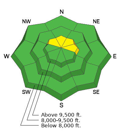
The avalanche danger is MODERATE on upper-elevation slopes facing northwest through north and east where light snowfall and winds may overload a widespread persistent weak layer. Avalanches may be triggered from a distance and one to two feet deep.

Dangerous avalanche conditions are likely this weekend with heavy snowfall possible later Saturday and into Sunday.
Low
Moderate
Considerable
High
Extreme
Learn how to read the forecast here
Special Announcements
Gear up for the season or score great deals on gifts for loved ones this holiday season while supporting the UAC’s efforts. Your participation directly funds the state's avalanche forecasting, awareness, and education programs. Check out the auction found here!

For those in the Central Wasatch, don't forget about the Dawn Patrol Hotline! Updated daily by 5:00–5:30 AM, you can get the latest information by calling 888-999-4019, option 6.
Weather and Snow
As of 6 am, temperatures are in the teens and winds from are the southwest and generally light, with gusts in the 20's mph along exposed ridges above 10,000' . Light snow began falling around 2 am with a trace to 1" of snow. Upper Little Cottonwood is an outlier with 5" of snow containing 0.2" water.
For today, temperatures will rise into the mid and upper 20's F and winds will remain light, with gusts in the 20's mph along upper elevation ridgelines and summits. Winds will be from the southwest this morning, transitioning to a more westerly direction as the day progresses. 3-5" of snow is expected by sunset, possibly more in some areas.

For this weekend, a short break overnight and into Saturday, with snow beginning late Saturday afternoon and lasting into Sunday. This storm will come in right-side up, beginning with warm, denser/heavier snow and ending with cold, lower-density snow. This could be a decent - and much-needed! - snow producer, with over a foot of snow and an inch of water. A weak system is expected around Tuesday, with a few inches of snow possible.
Recent Avalanches
A small, natural avalanche was reported on Thursday in upper Mineral Fork. This was on a northeast aspect at 10,000' and about 4" deep and 15-20' wide. It likely began as a sluff and triggered a shallow soft slab below.
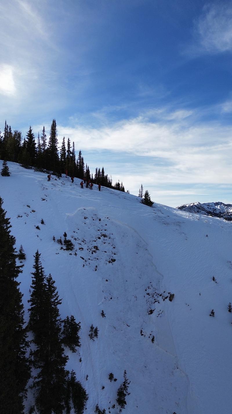
On Wednesday, the snow safety team at Park City Mountain Resort (PCMR) intentionally triggered an avalanche using explosives on a north-facing slope around 10,000' that failed on the persistent weak layer (PWL) and broke down to the ground. This avalanche was in closed terrain and has a backcountry snowpack. Working with the PCMR snow safety team on Thursday, Dave and Johanna Kelly looked at this avalanche and the overall snowpack along the Park City ridgeline and you can read the full report from their field day.

Be sure to read Nikki's Week in Review as part of your preparations before you head out this weekend.
Ad
Avalanche Problem #1
Persistent Weak Layer
Type
Location
Likelihood
Size
Description
It won't take much of a load for the fragile snowpack on northerly aspects to become reactive. On many slopes, the 1-2' deep snowpack is entirely faceted, and today's few inches of snow may be enough to trigger avalanches on mid and upper aspects facing northwest through east. Avalanches failing on this PWL may gouge down to the ground, as shown in the photo below from the avalanche intentionally triggered by PCMR on Wednesday.
Today's snow and wind may not be enough to tip this precarious balance, but if the weather forecast verifies, the Saturday/Sunday storm certainly will be.
Avalanche failing on faceted snow on northerly aspects.
General Announcements
This information does not apply to developed ski areas or highways where avalanche control is normally done. This forecast is from the U.S.D.A. Forest Service, which is solely responsible for its content. This forecast describes general avalanche conditions and local variations always occur.