Forecast for the Moab Area Mountains

Dave Garcia
Issued by Dave Garcia on
Friday morning, November 15, 2024
Welcome to the 2024/25 season! We will update this forecast on Mondays and Fridays until more snow arrives.
Update for Friday, 11/15:
Snow cover remains quite thin and there isn't much of an avalanche hazard out there right now. As always, if you are getting into the high country, suspect smooth, rounded pillows of wind drifted snow that may sound or feel hollow underneath. Any ride in an avalanche, even a small one, would be extremely rough right now.

Rocks, trees, and stumps pose serious hazards and recreating off of snow covered roads is not recommended.
Low
Moderate
Considerable
High
Extreme
Learn how to read the forecast here
Special Announcements
We have several events coming up to kick off the winter season:
Thursday, December 5 - FREE Know Before You Go avalanche awareness talk 6 PM at the Grand County Public Library
Saturday, December 7 - 17th Annual Utah Snow and Avalanche Workshop (USAW) - Information and tickets available here.
Saturday, Deember 14 - 3rd Annual UAC Moab/LUNA Winter Kickoff Party, 6 PM at the MARC (more info and tickets will be posted soon).
Weather and Snow
The mountains picked up 2 inches of snow on Tuesday, but overall coverage remains very thin. Sunshine and warm temperatures have reduced the snowpack to 12’’ at the Gold Basin Snotel site. A storm is moving in Friday night and Saturday, but this will mainly affect Northern Utah, leaving the La Sals high and dry. Our next chance for snow looks like Monday into Tuesday, but this storm is not impressive. High-pressure returns after Tuesday.
In my travels on Wednesday, I found a variety of conditions, including low-elevation sunny slopes completely melted to the ground and shady north-facing slopes holding 60-65 cm of snow. Rocks, stumps, and logs are a real hazard. I don't recommend trying to get any real turning and riding in just yet. The good news is there is enough snow to put skins on and walk around.
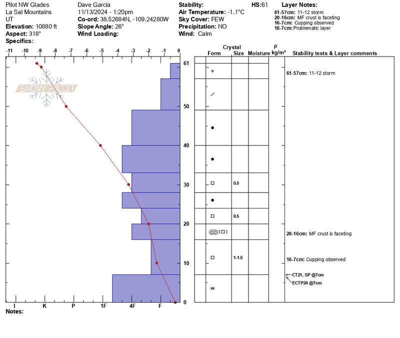
There have been some great early season observations coming in, and you can view them here. On Wednesday, I poked around on North facing slopes and found a cohesive slab overlying the weak facets at the base of the snowpack (see the pit profile below). Sunshine and warm temperatures have allowed the snowpack on this particular slope to settle and form a slab. In this location, the facets at the base of the snowpack reacted to stability tests. Looking to the future, this layer will be problematic when we get a good storm and add more of a load.
Snowpack and Weather Data
Gold Basin SNOTEL site (10,000')
SNOTEL site near Geyser Pass Winter Trailhead (9600')
Wind Station on Pre-Laurel Peak (11,400')
NWS forecast for the La Sal Mountains.
Ad
Additional Information
It’s never too early to start thinking about avalanches. Here are a few things to consider doing:
  • We have over 5 hours of free online learning at the Know Before You Go Website
  • Sign up for an on-snow class or in in person Know Before you Go Event.
  • Get your avalanche rescue gear ready for winter. Put fresh batteries in your transceiver and update the firmware. Inspect your shovel and probe. Get your airbag backpack ready by possibly doing a test deployment and updating the firmware if it is an electric version or getting your canister refilled if it's not electronic
General Announcements
This forecast is from the U.S.D.A. Forest Service, which is solely responsible for its content. This forecast describes general avalanche conditions and local variations always occur.