Check out our Holiday Auction - Sign Up for the Utah Snow and Avalanche Workshop (USAW)

Forecast for the Salt Lake Area Mountains

Trent Meisenheimer
Issued by Trent Meisenheimer on
Sunday morning, April 7, 2024
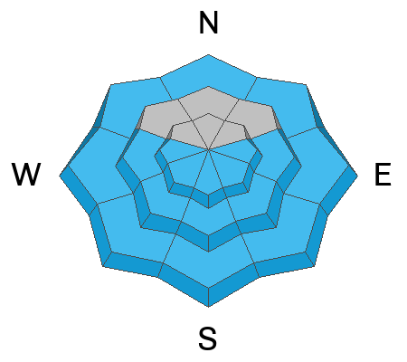
Today, the avalanche danger is CONSIDERABLE across all upper-elevation steep terrain for triggering soft slabs of Wind-Drifted Snow. We also have a MODERATE avalanche danger across all mid and upper-elevation terrain for New Snow avalanches. Here, loose-dry and soft slab avalanches failing within the new storm snow are possible.
The wild card is the strong April sunshine. See the Wet Snow description below.
Low
Moderate
Considerable
High
Extreme
Learn how to read the forecast here
Special Announcements
Do We Let Our Guard Down in the Spring? --- UAC Avalanche Education coordinator McKinley Talty looked at the numbers....and his blog just might surprise you.
Weather and Snow
Under partly cloudy skies the mountain temperatures remain cold and range from 10-20 °F. The west-northwest wind has been blowing at perfect loading speeds for the past 24 hours and this morning it's no different as it continues to blow west-northwest at speeds of 10-25 mph across the upper elevations.
The upper Cottonwoods were in the hot spot stacking up the high-end of the storm totals, while other areas lower in the canyons or along the Park City Ridgeline came in closer to 8-17 inches. Provo was left holding the bag.
  • SLC Area: 8" to 25" snow (0.87-1.67" swe)
  • Ogden Area: 4" to 10" snow (0.43-1.20" swe)
  • Provo Area: 2" to 4" snow (0.30-0.38" swe)
Today, we should see partly to mostly cloudy skies. One weather model showed snowfall until 2:00 PM, while another showed no chance of snow. Hopefully the first one is correct and we see light snowfall throughout the morning hours. In either case we are likely to only see a trace to a couple of inches at best. Temperatures will climb into the upper 20s to low 30s °F. Winds will remain from the west-northwest and blow 10-25 mph with gusts into the 20s and 30s.
Recent Avalanches
Yesterday seemed oddly quiet, with very few observations coming through. One avalanche was reported from Day's Fork in Crystal Palace. It was 9" deep x 150' wide, and they reported it to be surprising how fast and far it ran. Ski areas reported sensitive soft slab avalanches failing within the new snow on density changes.
Ad
Avalanche Problem #1
Wind Drifted Snow
Type
Location
Likelihood
Size
Description
For the past 24 hours, the west-northwest wind has been blowing at perfect loading speeds of 10-25 mph. Because of this, you can expect soft slabs of wind-drifted snow across the upper elevation ridgelines and on lee slopes. Be on the lookout for snow that looks pillowy, rounded, or wavy, and avoid those areas, as they are likely wind slabs.
Avalanche Problem #2
New Snow
Type
Location
Likelihood
Size
Description
Loose-dry avalanches (sluffs) will be easily initiated in steep terrain. With all the slick and hard underlying surfaces I would expect loose-dry avalanches to run fast and far and could pack a punch.
You will also want to be on guard for soft slab avalanches failing on or at the old snow surface or within the new storm snow itself (density changes). Soft slabs of new snow are usually more sensitive during high precipitation periods which is now over. Therefore you need to determine how the new snow is settling and bonding.
Shovel tilt tests, small test slopes, and slope cuts should be in your bag of tricks today. With 8 to 25 inches of new snow avalanches could be large enough to catch, carry, and bury a person. Work through the terrain, make conservative choices, and watch your sluffs.
Trend: Decreasing Danger
Avalanche Problem #3
Wet Snow
Type
Location
Likelihood
Size
Description
I am not adding a danger rating for this problem since it will depend completely on cloud cover and sunshine. The mountain temperatures are forecast to be cold with cloud cover and wind, so I have no clue if the sun will come out or if the new snow will be affected by warming.
It's April, and the sun is strong. All it takes is a few minutes of strong sunshine to warm the cold snow and instantly turn it wet and unstable. We can go from LOW danger to HIGH danger in a matter of minutes. Wet-loose avalanches in long steep sustained terrain can become very large and dangerous, especially with a very hard bed surface for them to run on. This time of year Wet Snow should be in the back of your mind every day.
General Announcements
This information does not apply to developed ski areas or highways where avalanche control is normally done. This forecast is from the U.S.D.A. Forest Service, which is solely responsible for its content. This forecast describes general avalanche conditions and local variations always occur.