UDOT PLANNED AVALANCHE CLOSURES!!

Forecast for the Uintas Area Mountains

Craig Gordon
Issued by Craig Gordon on
Wednesday morning, March 27, 2024
HEADS UP... with strong sunshine overhead, recent storm snow instantly takes on heat. If you're feeling like an ant under a magnifying glass... so is the snow.
Two different flavors of plant-based, organic avalanche dragon are on today's menu.
Cold snow-
At and above treeline, you'll find MODERATE avalanche danger, especially on steep slopes in the wind zone. Shallow, fresh drifts will react to our additional weight and human triggered avalanches are POSSIBLE on steep, wind drifted slopes, particularly those with an easterly component to their aspect.
Hot snow-
With strong sunshine overhead, nearly all aspects and elevations take on heat and the danger of damp slides and sluffs increases to MODERATE as the day wares on.

Low
Moderate
Considerable
High
Extreme
Learn how to read the forecast here
Special Announcements
Please help support the UAC rebuild our website backend platform to ensure the ongoing security of the website and the data stored on the site by donating to our spring campaign. Save lives by making a donation today!
Weather and Snow
Nowcast- Looking like a solid C student on the doppler, yesterday's storm got down to work, got comfortable in its own skin, and blossomed into an exceptional over-achiever. Working up quite the appetite, the little storm selected the super-size option at the local convenience store checkout as it rounded the bend, setting its sights on The North Slope, stacking up with 10" of snow and just over .70" H2O in the past 24 hours. The south half of the range got slighted on the invite, only stacking up about half that amount. In either case, the riding and turning conditions are five star, and low angle terrain is the ticket where you'll feel less of the old snow surface underfoot. But that was so yesterday... currently, a waning Worm Moon peaks through partly cloudy skies as temperatures hover in the upper teens. Along the high ridges, winds blow from the west and northwest, registering in the teens and low 20's near the high peaks.
Forecast- We can expect clearing skies with temperatures climbing into the mid 30's. Winds blow in the teens from the west this morning, switching to southwest and bumping into the 20's and 30's later this afternoon
Futurecast- The break in the action is short lived with the next round of storminess on tap for Thursday afternoon. Snow develops late in the day and continues through Friday... 6"-10" by the end of the work week seems like a good bet.
Recent Avalanches
Yesterday's storm snow stacked up fast and furious and was hyper-reactive to the additional weight of a rider... or a well-placed snowball :)

For all Uinta observations and archived avalanche activity click HERE.
Ad
Avalanche Problem #1
Wind Drifted Snow
Type
Location
Likelihood
Size
Description
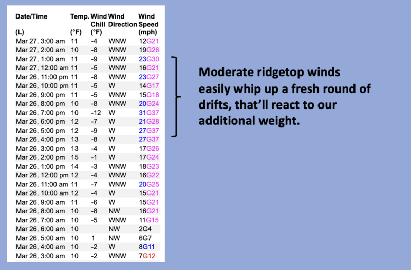
Image above, 24 hour data dump from Windy Peak (10,662')
Recent winds had no problem whipping yesterday's storm snow into fresh drifts that'll react to our additional weight. Found mostly on upper elevation shady slopes with an easterly component to its aspect, there may be a cross-loaded chute or gully in the mix. This is a straight-forward avalanche problem easily managed by simply traveling in wind sheltered terrain.
Avalanche Problem #2
Wet Snow
Type
Location
Likelihood
Size
Description
Yesterday's storm snow instantly takes heat on all but the highest, north facing slopes. And there's a myriad of hard, slick bed surfaces for avalanches to run on. Once initiated, today's "push-alanches" may entrain more snow than you might expect and could potentially carry you downhill. And remember... even a small, damp slide will stack up a surprising amount of tree snapping debris, especially if it piles up in a terrain trap like a gully or road cut. This is an easy avalanche problem to manage... simply avoid steep, sunbaked slopes as the day wares on and think about your exit strategy for later in the day when the snow is feeling like an ant under a magnifying glass. (And to be clear... no ants were injured in the use of this metaphor :)
Additional Information
The Uinta weather station network was upgraded this summer and all that real-time info is found HERE. Simply click on "western Uinta" tab and then "weather stations" tab.

We are always looking for snow and avalanche observations or just general riding conditions. So... if you see something, say something. You can reach me directly at [email protected] or 801-231-2170.
Also, if you're looking for more avy education opportunities for yourself, your crew, or your club please don't hesitate to reach out to me and we'll find a presentation, class, or clinic for ya!
General Announcements

Issued at 04:00 on Wednesday, March 27th this forecast will be updated by 0700 Thursday, March 28th, 2024.
This forecast is from the U.S.D.A. Forest Service, which is solely responsible for its content. This forecast describes general avalanche conditions and local variations always occur.