Forecast for the Ogden Area Mountains

Issued by Nikki Champion on
Sunday morning, February 25, 2024
Sunday morning, February 25, 2024
Today, the avalanche danger is MODERATE across all upper-elevation terrain for stubborn slabs of wind-drifted snow.
On low and mid-elevation slopes facing southwest through south and southeast, the avalanche danger may rise to MODERATE as the snow surface heats up, potentially leading to small wet-loose avalanches on solar aspects. The remaining aspects have a LOW avalanche danger.
It's crucial to carefully evaluate snow and terrain today, identifying potential hazards, as human-triggered avalanches are possible.

Low
Moderate
Considerable
High
Extreme
Learn how to read the forecast here
 Special Announcements
Join the UAC and Inspired Summit Adventures for the grand opening of our new Transceiver Training Park at Pinebrook, Sunday, February 25, from 3:00-6:00PM.
 Weather and Snow
This morning, under clear skies temperatures range from the mid-20s F to low 30s F. The westerly winds have begun to pick up overnight, averaging 10-15 mph with gusts up to 30 mph at mid-elevations, and gusts near 40 mph at upper elevations.
Today will be another day of strong sunshine, with temperatures warming into the upper 30s F at upper elevations and the mid-40s F at low and mid-elevations. Winds will remain from the west-southwest and continue to increase throughout the day, averaging 15-20 mph and gusting up to 30 at mid-elevations, with gusts near 45 mph at mid-elevations.
Outlook: On Monday, strong winds will start blowing as a new storm system approaches. This storm will be colder than recent ones and will bring heavy snow starting on Monday, mainly in the southwest. The snow levels will stay high, and the snow will be wet due to the direction of the wind. By early Tuesday, the storm front will pass through, bringing strong winds, heavy snow, and a quick drop in temperature. There might even be lightning near the front. Snow will continue on Tuesday, gradually easing off by Tuesday night, as the wind shifts to the northwest. This next storm could bring 10-20 inches of snow to the Ogden Area, favoring Ben Lomond on the front end of the storm.
Riding conditions remain excellent in the backcountry, although solar slopes may now have developed a firm crust this morning due to days of strong sun.
 Recent Avalanches
Avalanche activity yesterday included long-running dry-loose avalanches and cornice management within the ski resorts and backcountry.
Find all observations HERE.
Avalanche Problem #1
Wind Drifted Snow
Type
Location

Likelihood
Size
Description
With increasing winds before the next front, stubborn slabs of wind-drifted snow are likely on upper-elevation slopes and some mid-elevation areas where drifting snow accumulates. Some of these drifts may be reactive if formed on top of graupel. Graupel layers vary but are often found below steeper cliff bands where graupel accumulates.
These drifts could be 1-3 feet deep and up to 150 feet wide. Look out for signs like pillow-shaped deposits and avoid these slopes. Recent wind drifts were covered by snowfall Wednesday night, so digging down may be necessary.
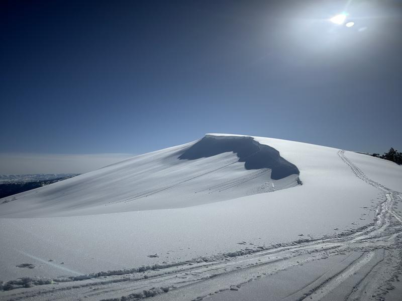
Cornices in the Ogden area are growing: Give them a wide berth as they often break farther back than expected and could gather a lot of snow.
Photo of growing cornice near Eyrie Peak - Chloe Mortensen - Full observation HERE.

Outside the wind zone, on shaded aspects, soft snow persists. Be cautious in steeper terrain, as even a loose-dry avalanche can travel far and pick up a lot of snow, especially in areas with graupel. Plan an exit strategy and manage sluff carefully.
Avalanche Problem #2
Wet Snow
Type
Location

Likelihood
Size
Description
The elevated winds should keep the wet snow at bay today, but with such strong sunshine and warm temperatures, there is still the potential to trigger wet-loose avalanches on steep, sunny slopes. If temperatures really heat up on mid and upper elevation slopes facing southeast, any wet avalanches may trigger larger slab avalanches, resulting in failure on the persistent weak layer (PWL).
Wet snow is the easiest avalanche problem to avoid; simply move to shady slopes once the snow surface becomes wet. Look for signs that the snow surface is becoming wet, such as rollerballs and pinwheels.
General Announcements
This information does not apply to developed ski areas or highways where avalanche control is normally done. This forecast is from the U.S.D.A. Forest Service, which is solely responsible for its content. This forecast describes general avalanche conditions and local variations always occur.


